A global isochron chart
by
J.-Y. Royer, R.D. Müller, L.M. Gahagan,
L.A. Lawver, C.L. Mayes, D. Nürnberg and J.G. Sclater
University of Texas Institute for Geophysics Technical Report No. 117,
1992
Introduction
Color images of plate reconstruction with isochrons
References for coastlines, sutures, continental
margins
References for plate boundaries
References for satellite interpretations
References for ship-track data by region
Finite poles of rotation used to reconstruct
isochrons
References
Introduction
The Paleoceanographic Mapping Project (POMP) began in 1984 as a global,
plate reconstruction project at the University of Texas at Austin Institute
for Geophysics (UTIG). Sponsored by a consortium of oil companies, the
original goals of POMP were to:
* build a digital, global data base of coastlines, plate boundaries,
and marine magnetic and tectonic data,
* develop software for digitizing, manipulating, and reconstructing
the data,
* develop a global model of plate motions through time based on the
data base.
By the end of the project in April, 1991, POMP had succeeded in achieving
these goals. POMP had provided its sponsors with both the data base and
a comprehensive, self-consistent plate motion model which described the
Mesozoic and Cenozoic evolution of the world's major ocean basins. The
data base included tectonic lineations interpreted from Seasat and Geosat
altimeter data, which permitted greatly improved reconstructions. The accuracy
of the reconstructions exceeded original expectations, and a well-constrained
plate model of the major ocean basins was developed.
In July of 1989, members of the POMP research team presented the POMP
database and plate model at the 28th International Geological Congress
in Washington, D.C. Included in their presentation was a series of isochrons
constructed using the data base and plate model. This report is meant to
serve as documentation of that presentation and of some of the results
of POMP itself.
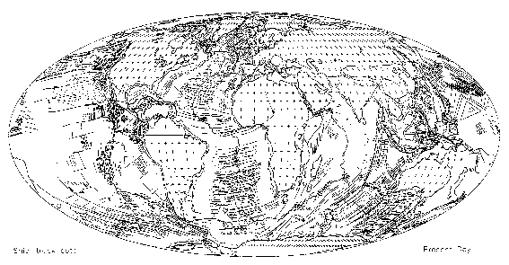
Figure 1 shows magnetic and fracture
zone lineations from 1) ship data in the POMP database (data sources are
listed by region below) and 2) and from Seasat and Geosat satellite altimetry
data.
Color images of plate reconstruction with isochrons
Figure 3 is a present-day map of isochrons and the current plate boundaries
dividing the tectonic plates. Plate reconstructions and isochrons were
constructed for the following anomaly times (chrons): 5
(9.7 Ma), 6 (20.1 Ma), 13
(33.1 Ma), 18 (40.1 Ma), 21
(47.9 Ma), 25 (55.9 Ma), 31
(67.7 Ma), 34 (83.5 Ma), M0
(120.4 Ma), M4 (126.7 Ma), M10N
(131.9 Ma), M16 (139.6 Ma), M21
(147.7 Ma), M25 (154.3 Ma), M29
(168.0 Ma), and
180 Ma.
References for coastlines, sutures, continental
margins
Barker and Lawver, 1986
Bott, 1987
Buffler et al., 1981
Case and Holcombe, 1980
Dunbar and Sawyer, 1986
Eldholm and Thiede, 1987
Emery and Uchupi, 1984
Fischer et al., 1971
General Bathymetric Chart of the Oceans, 1981
Hayes and Taylor, 1978
Johnson and Holmes, 1989
Kroenke et al., 1983
Ladd, 1974
Larsen, 1984
New Zealand Geological Survey, 1972
Nuernberg and Mueller, 1991
Otsuki and Ehiro, 1979
Piccirillo et al., 1988
Roest and Srivastava, 1989
Royer, 1987
Royer and Sandwell, 1989
Srivastava and Roest, 1989
Veevers, 1986
Veevers et al., 1985
World Data Bank #2 (CIA), 19??
Ziegler, 1982
References for plate boundaries
Barker, 1982
Cande et al., 1982
Cande et al., 1988
Cochran, 1981
Curray et al., 1979
Fischer et al., 1971
Guennoc et al., 1988
Hayes and Taylor, 1978
Hamilton, 1978
Hill and Hayward, 1988
Jennings, 1961
Johnson and Holmes, 1989
Klitgord and Schouten, 1986
Klitgord and Mammerickx, 1983
Larson et al., 1985
Mejorada, 1976
New Zealand Geological Survey, 1972
Otsuki and Ehiro, 1979
Packhorn, 1982
Rosencrantz et al., 1988
Ross and Scotese, 1988
Royer et al., 1988
Searle, 1980
References for satellite interpretations
Gahagan et al., 1988
Mayes et al., 1990
Nürnberg & Müller , 1991
Royer et al., 1989
References for ship-track data by region
Arctic Ocean
Canadian Hydrographic Service, 1981
Klitgord and Schouten, 1986
Ohta, 1982
Perry et al., 1985
North Atlantic Ocean
Barker and Lawver, 1986
Bott, 1987
Canadian Hydrographic Service, 1981
Eldholm and Thiede, 1987
Emery and Uchupi, 1984
Hill and Hayward, 1988
Klitgord and Schouten, 1986
Larsen, 1984
Perry et al., 1985
Roest and Srivastava, 1989
Ziegler, P.A., 1982
Caribbean
Buffler et al., 1981
Case and Holcombe, 1980
Mejorada, P., 1976
Rosencrantz et al., 1988
South Atlantic Ocean
Barker and Lawver, 1986
Cande et al., 1988
Emery and Uchupi, 1984
LaBrecque and Cande, 1986
LaBrecque and Hayes, 1979
Ladd, 1974
Martin et al., 1982
Nürnberg and Müller,1991
Rabinowitz and LaBrecque, 1979
Indian Ocean
Barker and Lawver, 1986
Barker and Lawver, 1986
Bergh, pers. comm.
Bergh, 1987
Cochran, 1988
Cochran, 1981
Davies et al., 1974
Fisher et al., 1971
General Bathymetric Chart of the Oceans, 1981
Goodlad et al., 1982
Guennoc et al., 1988
Karasik et al., 1986
LaBrecque and Hayes, 1979
Larson et al., 1978
Liu et al., 1982
Markl, 1974
Markl, 1978
McKenzie and Sclater, 1971
Mohr and Zannettin, 1988
Norton and Sclater, 1979
Patriat, 1987
Patriat, 1987
Rabinowitz and LaBrecque, 1979
Royer et al., 1988
Royer and Sandwell, 1989
Schlich, 1982
Schlich et al., 1987
Sclater et al., 1976
Segoufin, 1981
Segoufin and Patriat, 1981
Tapscott et al., 1980
Veevers, 1986
Veevers et al., 1985
Vogt et al., 1983
Weissel and Hayes, 1972
Whitmarsh, 1974
Whitmarsh et al., 1974
North Pacific Ocean
Cande et al., 1978
Caress et al., 1988
Currie et al., 1982
Elvers et al., 1967
Elvers et al., 1972
Hilde et al., 1976
Klitgord and Mammerickx, 1982
Lonsdale, 1988
Mammerickx et al., 1976
Mammerickx et al., 1988
Mammerickx and Sharman, 1988
Nakanishi et al., 1989
Nakanishi et al., 1992
Raff and Mason, 1961
Sharman and Risch, 1988
Tamaki et al., 1979
Tamaki et al., 1979
Theberge, 1971
Central Pacific Ocean
Handschumacher, 1976
Handschumacher et al.,1981
Herron,1972
Klitgord and Mammerickx, 1983
Mammerickx et al., 1980
Pardo-Casas and Molnar, 1987
South Pacific Ocean
Cande et al., 1982
Christofel and Falconer, 1972
Molnar et al., 1975
Weissel et al., 1977
Southeast Asia
Burns et al., 1973
Hamilton, 1978
Hayes and Taylor, 1978
Mammerickx et al., 1976
Finite poles of rotation used to reconstruct
isochrons
Time Latitude Longitude Angle Reference
North America to Northwest Africa
10.0 80.12 50.80 2.52 Mueller et al. 1990
20.0 79.57 37.84 5.29 Klitgord & Schouten 1986
35.5 75.37 1.12 10.04 Mueller et al. 1990
49.5 75.30 -3.88 15.25 Mueller et al. 1990
59.0 79.68 -0.46 18.16 Mueller et al. 1990
67.5 82.90 4.94 20.76 Mueller et al. 1990
72.5 81.35 -9.15 22.87 Klitgord & Schouten 1986
74.3 80.76 -11.76 23.91 Klitgord & Schouten 1986
80.2 78.30 -18.35 27.06 Klitgord & Schouten 1986
84.0 76.55 -20.73 29.60 Klitgord & Schouten 1986
118.0 66.30 -19.90 54.25 Klitgord & Schouten 1986
126.0 66.13 -19.0 56.39 Klitgord & Schouten 1986
131.5 65.95 -18.50 57.40 Klitgord & Schouten 1986
141.5 66.10 -18.40 59.79 Klitgord & Schouten 1986
149.5 66.50 -18.10 61.92 Klitgord & Schouten 1986
156.5 67.15 -16.0 64.70 Klitgord & Schouten 1986
170.0 67.02 -13.17 72.10 Klitgord & Schouten 1986
175.0 66.95 -12.02 75.55 Klitgord & Schouten 1986
Greenland to North America
35.5 0.00 0.00 0.00
49.0 59.50 -92.00 -2.81 This paper
56.0 54.91 -110.01 -4.00 Roest & Srivastava 1989
59.0 24.48 -137.25 -3.12 Roest & Srivastava 1989
61.0 20.61 -148.20 -3.27 Roest & Srivastava 1989
63.0 27.63 -149.41 -3.72 Roest & Srivastava 1989
69.0 43.94 -145.31 -4.92 Roest & Srivastava 1989
84.0 65.30 -122.45 -11.00 Roest & Srivastava 1989
92.0 66.60 -119.48 -12.20 Roest & Srivastava 1989
105.0 67.08 -118.96 -12.99 Roest & Srivastava 1989
118.0 67.50 -118.48 -13.78 Roest & Srivastava 1989
South America to Central Africa
1.9 60.00 -39.00 0.51 Cande et al. 1988
2.5 60.00 -39.00 0.77 Cande et al. 1988
3.9 60.00 -39.00 1.21 Cande et al. 1988
5.3 60.00 -39.00 1.78 Cande et al. 1988
6.7 60.00 -39.00 2.27 Cande et al. 1988
7.9 60.00 -39.00 2.76 Cande et al. 1988
8.9 60.00 -39.00 3.15 Cande et al. 1988
11.6 59.50 -38.00 4.05 Cande et al. 1988
14.9 59.50 -38.00 5.25 Cande et al. 1988
16.2 59.50 -38.00 5.75 Cande et al. 1988
17.6 59.50 -38.00 6.30 Cande et al. 1988
18.6 59.50 -38.00 6.70 Cande et al. 1988
19.4 59.50 -38.00 7.05 Cande et al. 1988
20.9 59.50 -37.75 7.60 Nuernberg & Mueller 1991
22.6 59.50 -36.50 8.45 Cande et al. 1988
23.3 59.50 -37.00 8.80 Nuernberg & Mueller 1991
25.5 59.00 -36.00 9.50 Cande et al. 1988
26.9 59.00 -36.00 10.00 Cande et al. 1988
28.2 58.00 -35.00 10.55 Cande et al. 1988
29.7 57.00 -35.00 11.05 Cande et al. 1988
31.2 57.00 -34.50 11.60 Nuernberg & Mueller 1991
32.5 57.50 -35.00 12.15 Cande et al. 1988
35.3 57.50 -34.00 13.38 Cande et al. 1988
37.2 57.00 -33.50 14.10 Cande et al. 1988
38.1 57.00 -33.25 14.40 Nuernberg & Mueller 1991
39.5 57.00 -33.00 15.05 Cande et al. 1988
41.3 57.50 -32.50 15.80 Cande et al. 1988
43.6 58.00 -32.00 17.00 Cande et al. 1988
44.7 57.50 -31.75 17.60 Cande et al. 1988
48.7 58.50 -31.50 19.07 Cande et al. 1988
51.9 59.00 -31.50 20.10 Cande et al. 1988
53.9 60.00 -32.00 20.75 Cande et al. 1988
55.1 60.00 -32.00 21.20 Cande et al. 1988
58.6 61.50 -32.50 22.30 Nuernberg & Mueller 1991
60.2 61.50 -32.50 22.70 Cande et al. 1988
63.0 62.50 -33.00 23.55 Cande et al. 1988
64.3 63.00 -33.30 24.00 Cande et al. 1988
65.5 63.00 -33.30 24.30 Cande et al. 1988
66.7 63.00 -33.30 24.70 Cande et al. 1988
68.5 63.00 -33.50 25.40 Cande et al. 1988
71.4 63.00 -33.50 26.60 Cande et al. 1988
74.3 63.00 -33.50 27.90 Cande et al. 1988
80.2 63.00 -34.00 31.00 Cande et al. 1988
84.0 61.75 -34.00 33.50 Cande et al. 1988
118.7 50.10 -34.60 52.78 This paper
121.0 50.00 -34.20 53.64 This paper
126.5 49.30 -33.80 54.29 This paper
131.5 49.10 -33.70 55.17 This paper
245.0 49.10 -33.70 55.17 This paper
Eurasia to North America
10.0 65.38 133.58 -2.44 Lawver et al. 1990
20.0 68.92 136.74 -4.97 Lawver et al. 1990
36.0 65.64 136.95 -7.51 Lawver et al. 1990
49.0 67.19 137.74 -10.91 Srivastava & Roest 1989
56.0 62.60 140.81 -12.75 Srivastava & Roest 1989
59.0 63.14 141.66 -14.22 Srivastava & Roest 1989
69.0 64.84 143.96 -16.95 Srivastava & Roest 1989
80.0 66.17 147.74 -19.00 Srivastava & Roest 1989
84.0 66.54 148.91 -19.70 Srivastava & Roest 1989
92.0 66.67 150.26 -20.37 Srivastava & Roest 1989
105.0 66.85 152.34 -21.49 Srivastava & Roest 1989
118.0 68.99 154.75 -23.05 Srivastava & Roest 1989
145.0 68.99 154.75 -23.05 Srivastava & Roest 1989
170.0 69.10 156.70 -23.64 This paper
Iberia to Eurasia
0.0 0.00 0.00 0.00
30.0 90.00 0.00 0.00
Iberia to Northwest Africa
30.0 31.4 -18.60 7.87 Srivastava & Tapscott 1986 fit
133.2 31.4 -18.60 7.87 Srivastava & Tapscott 1986
Iberia to North America
133.2 70.30 -11.00 -51.50 calculated from Srivastava & Tapscott
1986
Porcupine plate to North America
0.0 0.00 0.00 0.00
10.0 65.38 133.58 -2.44 Lawver et al. 1990
20.0 68.92 136.74 -4.97 Lawver et al. 1990
36.0 65.64 136.95 -7.51 Lawver et al. 1990
49.0 58.75 142.49 -10.01 Srivastava & Roest 1989
56.0 59.21 143.14 -12.29 Srivastava & Roest 1989
59.0 60.10 143.68 -13.76 Srivastava & Roest 1989
69.0 62.31 145.52 -16.47 Srivastava & Roest 1989
80.0 63.90 148.92 -18.51 Srivastava & Roest 1989
84.0 64.35 149.97 -19.21 Srivastava & Roest 1989
92.0 64.55 151.19 -19.88 Srivastava & Roest 1989
105.0 64.82 153.08 -21.00 Srivastava & Roest 1989
118.0 67.13 155.32 -22.54 Srivastava & Roest 1989
Rockall to North America
0.0 0.00 0.00 0.00
10.0 65.38 133.58 -2.44 Lawver et al. 1990
20.0 68.92 136.74 -4.97 Lawver et al. 1990
36.0 65.64 136.95 -7.51 Lawver et al. 1990
49.0 63.62 141.96 -10.52 Srivastava & Roest 1989
56.0 54.86 143.39 -11.99 Srivastava & Roest 1989
59.0 56.24 143.78 -13.44 Srivastava & Roest 1989
69.0 59.05 147.21 -15.56 Srivastava & Roest 1989
80.0 69.31 152.06 -19.31 Srivastava & Roest 1989
84.0 72.29 154.49 -20.94 Srivastava & Roest 1989
92.0 73.95 156.24 -22.00 Srivastava & Roest 1989
118.0 75.32 159.61 -23.47 Srivastava & Roest 1989
India to Central Indian Basin
0.0 90.00 0.00 0.00 This paper
10.5 -8.70 76.90 2.75 This paper
20.5 -0.90 74.60 6.77 This paper
70.0 -0.90 74.60 6.77 This paper
India to East Antarctica
70.0 13.00 7.20 -50.08 This paper
80.2 8.20 11.00 -62.18 Royer & Sandwell 1989
84.0 7.80 10.90 -65.10 Royer & Sandwell 1989
India to Madagascar
84.0 17.50 22.60 -55.41 Royer & Sandwell 1989
100.0 18.20 24.60 -61.92 This paper
115.0 19.40 27.10 -59.74 This paper
140.0 19.10 31.20 -61.99 calculated from Lawver & Scotese 1987
India to East Antarctica
140.0 -4.40 16.70 -92.77 Lawver & Scotese 1987
Arabia to Central Africa
0.0 0.00 0.00 0.00
4.7 32.80 22.60 -1.89 LePichon & Gaullier 1988
13.0 32.20 22.60 -5.36 LePichon & Gaullier 1988
30.0 32.10 22.60 -6.36 LePichon & Gaullier 1988
Central Indian Basin to Australia
0.0 90.00 0.00 0.00
42.7 90.00 0.00 0.00
Central Indian Basin to East Antarctica
42.7 16.60 29.90 -23.62 This paper
46.2 16.30 28.50 -25.24 Royer & Sandwell 1989
50.4 14.90 26.00 -27.77 This paper
56.1 12.30 21.50 -34.40 Royer & Sandwell 1989
64.3 9.70 17.40 -45.12 Royer & Sandwell 1989
68.5 9.40 13.70 -51.59 Royer & Sandwell 1989
80.2 8.20 11.00 -62.18 Royer & Sandwell 1989
84.0 7.80 10.90 -65.10 Royer & Sandwell 1989
Central Africa paleomagnetic reference frame
0.0 0.00 0.00 0.00
14.0 0.00 92.00 5.00 Ziegler et al. 1983
44.0 0.00 113.00 12.00 Ziegler et al. 1983
60.0 0.00 126.00 10.00 Ziegler et al. 1983
75.0 0.00 129.00 17.00 Ziegler et al. 1983
93.0 0.00 151.00 20.00 Ziegler et al. 1983
131.0 0.00 156.00 35.00 Ziegler et al. 1983
175.0 0.00 166.00 36.00 Ziegler et al. 1983
192.0 0.00 172.00 31.00 Ziegler et al. 1983
Madigascar to Central Africa
0.0 0.00 0.00 0.00
115.0 90.00 0.00 0.00
118.7 5.40 -76.20 0.90 This paper
123.0 5.40 -76.20 1.96 This paper
126.5 5.40 -76.20 3.19 This paper
129.4 5.40 -76.20 4.20 This paper
141.9 5.40 -76.20 8.32 This paper
149.9 4.00 -71.40 11.32 This paper
165.0 -3.41 -81.70 19.73 Lawver and Scotese 1987
Mascarene Plateau to Madigascar
0.0 90.00 0.00 0.00
63.0 90.00 0.00 0.00
64.3 -15.10 49.90 -10.48 Patriat unpublished manuscript
68.5 5.90 30.00 -12.74 Patriat unpublished manuscript
73.4 4.30 32.80 -20.01 Patriat unpublished manuscript
84.0 -4.50 46.00 -45.16 This paper
96.0 -2.90 44.80 -50.00 This paper
Northwest Africa to Central Africa
0.0 0.00 0.00 0.00
84.0 0.00 0.00 0.00
118.7 8.80 98.70 0.37 This paper (fit)
Northwest Africa to South America
118.7 50.00 -35.20 -52.90 This paper
Australia to East Antarctica
0.0 90.00 0.00 0.00
10.5 13.10 36.10 -6.61 Royer & Chang 1991
20.5 15.40 32.70 -11.97 Royer & Chang 1991
35.5 13.80 33.40 -20.41 Royer & Chang 1991
42.7 16.60 29.90 -23.62 Royer & Sandwell 1989
46.2 15.10 31.30 -24.50 Royer & Sandwell 1989
56.1 12.50 31.70 -25.24 Royer & Sandwell 1989
68.5 8.70 33.20 -25.83 Royer & Sandwell 1989
80.2 6.20 35.10 -26.37 Royer & Sandwell 1989
84.0 4.90 35.80 -26.81 Royer & Sandwell 1989
96.0 1.00 38.00 -28.30 Royer & Sandwell 1989
130.0 -2.00 38.90 -31.50 Royer & Sandwell 1989
East Antarctica to Central Africa
0.0 0.00 0.00 0.00
10.5 8.20 -49.40 1.53 Royer & Chang 1991
20.5 10.70 -47.90 2.78 Royer & Chang 1991
35.5 12.00 -48.40 5.46 Royer & Chang 1991
46.2 11.40 -43.70 7.81 Royer et al. 1988
50.3 10.30 -42.90 8.77 Royer et al. 1988
56.1 6.70 -40.60 9.97 Royer et al. 1988
60.8 3.80 -39.70 10.63 Royer et al. 1988
64.3 0.60 -39.20 11.32 Royer et al. 1988
66.2 -0.40 -39.40 11.59 Royer et al. 1988
68.5 1.10 -41.60 11.84 Royer et al. 1988
73.6 -1.80 -41.40 13.47 Royer et al. 1988
80.2 -4.70 -39.70 16.04 Royer et al. 1988
84.0 -2.00 -39.20 17.85 Royer et al. 1988
118.7 -4.20 -29.10 42.80 This paper
123.0 -4.60 -29.10 44.17 This paper
141.9 -7.00 -26.90 50.70 This paper
149.9 -4.70 -29.00 52.84 This paper
165.0 -7.78 -31.42 58.00 Lawver & Scotese 1987
Marie Byrdland to East Antarctica
0.0 0.00 0.00 0.00
95.0 0.00 0.00 0.00
130.0 62.27 21.84 13.27 Lawver & Scotese 1987
245.0 62.27 21.84 13.27 Lawver & Scotese 1987
Bellinghausen plate to Pacific
0.0 0.00 0.00 0.00
4.7 66.20 -83.50 - 4.13 Mayes et al. 1990
10.6 70.44 -78.84 -9.12 Mayes et al. 1990
25.8 73.13 -72.44 -19.52 Mayes et al. 1990
30.0 73.73 -69.54 -22.52 Mayes et al. 1990
35.9 73.67 -65.98 -26.68 Mayes et al. 1990
42.7 72.78 -64.61 -29.89 Mayes et al. 1990
49.6 72.09 -63.44 -33.93 Mayes et al. 1990
59.2 71.81 -60.67 -39.39 Mayes et al. 1990
65.1 70.77 -58.37 -45.52 Mayes et al. 1990
69.4 70.31 -56.34 -50.92 Mayes et al. 1990
74.0 69.92 -54.75 -56.33 Mayes et al. 1990
Kerguelen to East Antarctica
0.0 90.00 0.00 0.00
50.0 90.00 0.00 0.00
50.0 15.10 31.30 24.60 This paper
155.0 15.10 31.30 24.60 This paper
Lord Howe Rise to Australia
0.0 0.00 0.00 0.00
55.7 0.00 0.00 0.00 Weissel & Hayes 1977
60.5 -1.50 138.50 -2.55 Weissel & Hayes 1977
65.8 -5.50 140.50 -6.60 Weissel & Hayes 1977
72.7 -11.40 1 41.50 -12.75 Weissel & Hayes 1977
77.2 -14.00 142.00 -19.00 Weissel & Hayes 1977
84.0 -14.00 148.00 -23.34 This paper (fit)
245.0 -14.00 148.00 -23.34 This paper
Pacific to Marie Byrdland
0.0 0.00 0.00 0.00
4.8 66.20 -83.50 4.13 Mayes et al. 1990
10.6 70.44 -78.84 9.12 Mayes et al. 1990
26.0 73.13 -72.44 19.52 Mayes et al. 1990
30.3 73.73 -69.54 22.52 Mayes et al. 1990
35.9 73.67 -65.98 26.68 Mayes et al. 1990
42.7 72.78 -64.61 29.89 Mayes et al. 1990
49.5 -73.42 122.78 -35.15 Stock & Molnar 1987
50.3 72.09 -63.44 33.93 Mayes et al. 1990
59.2 70.32 -63.45 36.77 Mayes et al. 1990
65.1 68.69 -63.47 39.88 Mayes et al. 1990
69.4 67.12 -63.02 4.53 Mayes et al. 1990
84.0 64.94 -62.49 53.09 Mayes et al. 1990
90.0 64.03 -56.96 57.65 Mayes et al. 1990
For times older than 90 Ma, the Pacific plate is fixed to the global
reference frame
90.0 64.00 -73.30 54.47 calculated from Mayes et al. 1990
Nazca to Pacific
0.0 0.00 0.00 0.00
4.8 58.86 -89.43 -6.60 Mayes et al. 1990
10.6 60.13 -89.76 -15.18 Mayes et al. 1990
20.5 64.50 -91.50 -30.70 calculated from Mayes et al. 1990
26.0 65.41 -92.00 -39.35 Mayes et al. 1990
26.0 38.80 -84.30 -20.79 This paper
Vancouver to Pacific
0.0 0.00 0.00 0.00
10.4 72.00 6.40 -14.76 This paper
20.5 82.60 4.60 -15.65 This paper
35.3 88.50 -134.00 -34.99 This paper
41.3 87.50 -161.00 -43.34 This paper
48.8 86.50 -168.90 -51.80 This paper
61.0 85.20 125.80 -59.54 This paper
69.0 82.50 108.40 -66.24 This paper
84.0 77.10 93.60 -75.91 This paper
133.5 63.80 78.60 -108.58 This paper
158.0 57.10 81.10 -121.36 This paper
Jan Mayen to Eurasia
0. 0.00 0.00 0.00
36.0 0.00 0.00 0.00
42.7 64.90 -12.20 -22.60 This paper
46.2 64.90 -12.30 -31.60 This paper
49.0 64.30 -12.70 -37.30 Lawver et al. 1990
52.6 64.00 -12.90 -41.70 This paper
54.7 63.10 -13.50 -40.90 This paper
56.0 63.10 -13.50 -50.00 Lawver et al. 1990
Jan Mayen to Greenland
56.0 73.40 -10.80 -55.45 calculated from Lawver et al. 1990 (fit)
245.0 73.40 -10.80 -55.45 calculated from Lawver et al. 1990 (fit)
Cocos to Pacific
0.0 90.00 0.00 0.00
4.8 36.80 -108.60 -10.03 DeMets et al. 1990
10.4 34.00 -106.80 -22.73 This paper
20.5 37.30 -113.30 -31.62 This paper
20.5 55.40 -117.70 -42.28 This paper
Izanagi to Pacific
0.0 0.0 0.0 0.0
84.0 0.0 0.0 0.0 Engebretson 1983
131.7 54.5 6.6 64.15 This paper
141.9 64.7 15.7 68.33 This paper
149.9 57.5 96.3 87.76 This paper
156.6 60.5 80.8 79.43 This paper
References
Barker, P. and Lawver, L., 1986, unpublished.
Barker, P.F., 1982, The Cenozoic subduction history of the Pacific
margin of the Antarctic Peninsula: ridge crest-trench interactions, J.
Geol. Soc. London, 139: 787-801.
Bergh, H.W., 1987, Underlying fracture zone nature of Astrid Ridge
off Antarctica's Queen Maud Land, J. Geophys. Res., 92: 475-484.
Bergh, H.W., pers. comm.
Bott, M.N.P., 1987, The continental margin of central East Greenland
in relation to North Atlantic plate tectonic evolution, J. Geol. Soc.,
London, 144: 561-568.
Buffler, R., Shaub., J. Huerta, R., Ibrahim, A. and Watkins, D., 1981,
A model for the early evolution of the Gulf of Mexico Basin, Oceanol. Acta,
C3, pp. 129-136.
Burns, R.E., Andrews, J.E., et al., 1973, Initial Reports of the Deep
Sea Drilling Project, Leg XXI, Washington (U.S. Govt. Printing Office).
Canadian Hydrographic Service, 1981, General Bathymetric Map of the
Oceans (GEBCO), scale 1:10,000,000.
Cande, S., LaBrecque, J.L., and Haxby, W.B., 1988, Plate kinematics
of the South Atlantic: Chron 34 to present, J. Geophys. Res., 93(B11):
13479-13492.
Cande, S.C., Herron, E.M., and Hall, B.R., 1982, The early Cenozoic
history of the southeast Pacific, Earth Planet. Sci. Letters, 57: 47-62.
Cande, S.C., Larson, R.L., and LaBrecque, J.L., 1978, Magnetic lineations
in the Pacific Jurassic Quiet Zone, Earth Planet. Sci. Letters, 41: 434-440.
Caress, D.W., Menard, H.W., and Hey, R.N., 1988, Eocene reorganization
of the Pacific-Farallon Spreading Center north of the Mendocino Fracture
Zone, J. Geophys. Res., 93: 2813-2838.
Case, J. and Holcombe, T., 1980, Gologic-tectonic map of the Caribbean
region, scale 1:2,500,000.
Christofel, D.A. and Falconer, R.F., 1972, Marine magnetic measurements
in the southwest Pacific Ocean and the identification of new tectonic features,
Antarctic Oceanology II -The Antarctic - New Zealand Sector.
Cochran, J. R., 1981, The Gulf of Aden: Structure and evolution of
a young ocean basin and continental margin, J. Geophys. Res., 86: 263-287.
Cochran, J.R., 1988,The Somali Basin, Chain Ridge and the origin of
the northern Somali Basin gravity and geoid low, J. Geophys. Res., 93(B10):
11,985 - 12,008.
Curray, J.R., Moore, D.G., Lawver, L.A., Emmel, F.J., Raitt, R.W.,
Henry, M., and Kieckhefer, R., 1979, Tectonics of the Andaman Sea and Burma,
in J.S. Watkins, J. Montadert and P.W. Dickerson (editors), Geological
and Geophysical Investigations of Continental Margins, pp. 189-198.
Currie, R.G., Seeman, D.A., and Riddihough, R.P., 1982, Total field
magnetic anomaly offshore British Columbia, Geological Survey of Canada
Open-File Report 828, scale 1:1,000,000.
Davies, T.A., Luyendyk, B.P., et al., 1974, Leg XXVI, Initial Reports
of the Deep Sea Drilling Project, Washington (U.S. Govt. Printing Office).
DeMets, C., Gordon, R.G., Argus, D.F., and Stein, S., 1990, Current
plate motions, Geophysical Journal International, 101: 425-478.
Dunbar, J. and Sawyer, D., 1986, Crust extension within the Gulf of
Mexico: Implications for the breakup of Western Pangea, abs. from 1986
Geodynamics Symposium.
Eldholm, O. and Thiede, J., 1987, Summary and preliminary conclusions,
OPD Leg 104: Proceedings, Ocean Drilling Program Initial Reports, Part
A, 751-771.
Elvers, D.J., Mathewson, C.C., Kohler, R.E., and Moses, R.L., 1967,
Systematic ocean surveys by the USC and GSS Pioneer 1961-1963: Coast and
Geodetic Survey Operational Data Report C and GSDR-1, 19 P.
Emery, K.O. and Uchupi., E., 1984, The Geology of the Atlantic Ocean,
Springer, New York, 1050 p. 9301
Fischer, A.G., et al., 1971, Initial Reports of the Deep Sea Drilling
Project, Leg VI, Washington (U.S. Govt. Printing Office).
Fisher, R.L., Sclater, J.G. and McKenzie, D., 1971, Evolution of the
Central Indian Ridge, GSA Bull. 82: 553-562.
Gahagan, L.M., Scotese, C.R., Royer, J.-Y., Sandwell, D.T., Winn, J.K.,
Tomlins, R.L., Ross, M.I., Newman, J.S., Müller, R.D., Mayes, C.L.,
Lawver, L.A., and Heubeck, C.E., 1988, Tectonic fabric map of the ocean
basins from satellite altimetry data, Tectonophysics, 155: 1-26.
Goodlad, S.W., Martin, A.K., and Hartnady, C., 1982, Mesozoic magnetic
anomalies in the southern Natal Valley, Nature, 295: 686-688.
Guennoc, P. Pautot, G., and Coutell, A., 1988, Surficial structures
of the northern Red Sea azial valley from 23°N to 28°N: time and
space evolution of neo-oceanic structures, Tectonophysics Special Issue
on The Gulf of Suez and Red Sea rifting, 153: 1-23.
Hamilton, Warren, 1978, Tectonic map of the Indonesian region,USGS
Survey, Map I-875-D, Reston, Va.
Handschumacher, D.W., 1976, Post-Eocene plate tectonics of the Eastern
Pacific, in The Geophysics of the Pacific Ocean Basin and its Margins,
in The Geophysics of the Pacific Ocean Basin and its Margins, AGU Monograph
19, ed.G.H.Sutton, et al., Washington: AGU, pp. 177-202.
Handschumacher, D.W., Pilger, R.H. Jr., Foreman, J.A., and Campbell,
J.F., 1981, Structure and evolution of the Easter plate, GSA Memoir 154,
pp. 63-76.
Hayes, D.E. and Taylor, B., 1978, A geophysical atlas of the East and
Southeast Asian Seas, GSA Map and Chart Series MC-25,Washington, D.C.
Herron, E.M.,1972, Sea-floor spreading and the Cenozoic history of
the east-central Pacific, GSA Bull., 83: 1671-1692.
Hilde, T.W.C., Isezki, Nobuhiro, and Wageman, J.M., 1976, in The Geophysics
of the Pacific Ocean Basin and its Margins, p. 205-226 (Geophys. Mono.
19).
Hill, K.C. and Hayward, A.B., 1988, Structural constraints on the Tertiary
plate tectonic evolution of Italy, Mar. Petr. Geol., 5: 2-16.
Jennings, C.W., 1961, Geologic map of California: Kingman sheet, scale
1:250,000, California Division of Mines and Geology, Sacramento, CA.
Johnson, H.P. and Holmes, M.L., 1989, Evolution in plate tectonics:
The Juan de Fuca Ridge, in Winterer, E.L., Hussong, D.M. and Decker, R.W.
(eds), The Eastern Pacific Ocean and Hawaii, The Geology of North America,
Geological Society of America, Boulder, Colorado, Vol. N., pp. 73-91.
Karasik, A.M., Mercuryer, S.A., Mitin, L.I., Sochevanova, N.A., Yanovsky,
V.N., 1986, Documents of the Academy of Science of the USSR, 286: 933-938.
Klitgord, K.D. and Mammerickx, J., 1983, Northern East Pacific Rise:
Magnetic anomaly and bathymetric framework, J. Geophys. Res., 6725-6750.
Klitgord, K.D. and Schouten, H. 1986, Plate kinematics of the central
Atlantic, in Vogt, P.R. and Tucholke, B.E., eds., The Western North Atlantic
Region, GSA DNAG vol. M, pp. 351-378.
Kroenke, L.W., Jouannic, C. and Woodward, P., 1983, Bathymetry of the
southwest Pacific, Geophysical Atlas of the southwest Pacific, chart 1,
UNIGCP 110, United Nations ESCAP, New York.
LaBrecque, J.L. and Cande, S.C., 1986, Total intensity magnetic anomaly
profiles, Northwest Ocean Margin Drilling Program, Regional Data Synthesis
Series, Atlas 13, S. Atlantic Ocean and Adjacent Antarctic Continental
Margin.
LaBrecque, J.L. and Hayes, D.E., 1979, Seafloor spreading history of
the Agulhas Basin, Earth and Planet. Sci. Letters, 45: 411-428.
Ladd, J.W., 1974, South Atlantic seafloor spreading and Carribean tectonics,
Ph.D.thesis, 251pp., Columbia University, New York, 1974.
Larsen, H.L., 1984, Geology of the East Greenland shelf: in Petroleum
Geology of the North European Margin, Norweg. Pet. Soc., Graham & Trotman,
pp. 329-339.
Larson R.L., Carpenter, G.B., and Diebold, J.B., 1978, A geophysical
study of the Wharton Basin near the Investigator Fracture Zone, J. Geophys.
Res., 83(B2): 773-782.
Larson, R.L., Pitman, W.C., Golobchenko, X., Cande, S.C., Dewey, J.F.,
Haxby, W.F. and LaBrecque, J.L., 1985, The Bedrock Geology of the World
(color map), Freeman and Co., New York, NY.
Lawver, L.A., Müller, R.D., Srivastava, S.P., and Roest, W., 1990,
The Opening of the Arctic Ocean, in Geologic History of the Polar Oceans:
Arctic Versus Antarctic, U. Bleil and J. Thiede (eds.), from the NATO Symposium
(October, 1988) in Bremen, West Germany, pp. 29-62.
Lawver, L.A., and Scotese, C.R., 1987, A revised reconstruction of
Gondwanaland, in McKenzie, G.D., ed., Gondwana Six: Structure, Tectonics,
and Geophysics, AGU Geophysical Monograph 40 , 17-24.
LePichon, X. and J.-M. Gaulier, 1988, The rotation of Arabia and the
Levant fault system, Tectonophysics, 153: 271-294.
Liu, C.S., Curray, J., and McDonald, J.M., 1982, New constraints on
the tectonic evolution of the Eastern Indian Ocean, Earth and Planet.Sci.
Letters, 331-342.
Lonsdale, P., 1988, Structural patterns of the Pacific floor offshore
of Peninsula California, in Gulf and Peninsula Provinces of the Californias,
AAPG Memoir, in press.
Mammerickx, J., Fisher, R.L., Emmel, K.J., and Smith, S.M., 1976, Bathymetry
of the East and Southeast Asian Seas, GSA Map and Chart Series MC-17, Washington,
D.C.
Mammerickx, J., Herron, E.M., and Dorman, L., 1980, Evidence for two
fossil spreading ridges in the southeast Pacific, GSA Bull.,91: 263-271.
Mammerickx, J., Naar, D.F., and Tyuce, R.L., 1988, The Mathematician
Paleo-plate, J. Geophys. Res., 93: 3025-3040.
Mammerickx, J. and Sharman, G.F., 1988, Tectonic evolution of the North
Pacific during the Cretaceous Quiet Period, J. Geophys, Res., 93: 3009-3024.
Markl, R.G., 1974, Evidence for the breakup of Eastern Gondwanaland
by the Early Cretaceous, Nature, 251: 196-199.
Markl, R.G., 1978, Further evidence for the Early Cretaceous breakup
of Gondwanaland off Southwestern Australia, Earth and Planet. Sci. Letters,
39: 211-225.
Martin, A.K., Goodlad, S.W., Hartnady, C.J.H., and du Plessis, A.,1982,
Cretaceous paleopositions of the Falkland Plateau relative to southern
Africa using Mesozoic seafloor spreading anomalies,Geophys. J. R. astr.
Soc., 71: 567-579.
Mayes, C.L., Lawver, L.A., and Sandwell, D.T., 1990, Tectonic history
and new isochron chart of the South Pacific, Journal of Geophysical Research,
95(B6), pp. 8543-8567, 1990.
McKenzie, D. and Sclater, J.G., 1971,The evolution of the Indian Ocean
since the Late Cretaceous, Geophys J. Roy. Ast. Soc., 25: 437-528.
Mejorada, P., 1976, Carta geologica del la Republica Mexicana, scale
1:2,000,000.
Mohr, P., and Zannettin, B., 1988. The Ethiopian flood basalt province.
In Macdougall, J.D., ed., Continental Flood Basalts: Dordrecht, The Netherlands
(Kluwer), 63-110.
Molnar, P., Atwater, T., Mammerickx, J., and Smith, S.M., 1975, Magnetic
anomalies, bathymetry, and the tectonic evolution of the South Pacific
since the Late Cretaceous, Geophys. J.R. Astr. Soc., 40: 383-420.
Müller, R.D., Sandwell, D.T., Tucholke, B.E., Sclater, J.G., and
Shaw, P.R., 1990, Depth to basement and geoid expression of the Kane Fracture
Zone: a comparison, Marine Geophysical Researches, 13: 105-129.
Müller, R.D. and Roest, W.R., 1992, Fracture zones in the North
Atlantic from combined Geosat and Seasat data, Journal of Geophysical Research,
97(B3): 3337-3350.
Nakanishi, M., Tamaki, K., and Kobayashi, K., 1989, Mesozoic magnetic
anomaly lineations and seafloor spreading history of the Northwestern Pacific,
Journal of Geophysical Research, 94(B11): 15,437-15,462.
Nakanishi, M., Tamaki, K., and Kobayashi, K., 1992, Magnetic anomaly
lineations from Late Jurassic to Early Cretaceous in the west-central Pacific
Ocean, Geophysical Journal International, 109: 701-719.
New Zealand Geological Survey, 1972, "Geological map of New Zealand
1:1,000,000", North and South Islands sheets (1st edition), Department
of Scientific and Industrial Research, Wellington, New Zealand.
Norton, I.O. and Sclater, J.G., 1979, A model for the evolution of
the Indian Ocean and the breakup of Gondwanaland, J. Geophys. Res., 84:
6803-6830.
Nürnberg, D. and Müller, R.D., 1991, The tectonic evolution
of the South Atlantic from Late Jurassic to present, Tectonophysics, 191:
27-53.
Ohta, Y., 1982, Morpho-tectonic studies around Svalbard and the northernmost
Atlantic, Can. Soc. Pet. Geol. Mem. 8, pp. 415-429.
Otsuki, K. and Ehiro, M., 1979, Major strike-slip faults and their
bearing on spreading in the Japan Sea, in Uyeda, S., Murphy, R.W., and
Kobayashi, K. (eds.), Geodynamics of the Western Pacific, Proceedings of
the International Conference on Geodynamics of the Westrn Pacific-Indonesian
Region, March 1978, Tokyo, Advances in Earth and Planetary Sciences, vol.
6, pp. 537-555.
Packhorn, G.H. (Ed.), 1982, The evolution of the India-Pacific plate
boundaries, Tectonophysics, Special Issue, 87: 1-397.
Pardo-Casas, F. and Molnar, P., 1987, Relative motion of the Nazca
(Farallon) and South American plates since Late Cretaceous time, Tectonics,
6(3): 215-232.
Patriat, P., 1987, Reconstitution de l'évolution du systéme
de dorsales de l'Océan Indien par les méthodes de la cinématique
des plaques, Territoire des Terres Australes et Antarctique Françcaises
(ed.), 308 p., PhD Thesis, Université de Paris VI, France. [Central
Indian Ridge]
Perry, R.K., Fleming, H.S., Weber, J.R., Kristoffersenn, Y., Hall,
J.K., Grantz, A., and Johnson, G.L., 1985, Bathymetry of the Arctic Ocean,
Naval Research Laboratory - Acoutistics Division, scale 1:4,704,075 at
78°N.
Piccirillo, E.M., Melfi, A.J., Comin-Chiaramonti, P., Bellieni, G.,
Ernesto, M., Margues, L.S., Nardy, A.J.R., Pacca, I.G., Roisenberg, A.,
and Stolfa, D., 1988. Continental flood volcanism from the Paraná
Basin (Brazil). In Macdougall, J.D., ed., Continental Flood Basalts: Dordrecht,
The Netherlands (Kluwer), 195-238.
Rabinowitz, P.D. and LaBrecque, J.L., 1979, The Mesozoic South Atlantic
Ocean and evolution of its continental margins, J. Geophys. Res., 84: 5973-6002.
Raff, A.D. and Mason, R.G., 1961, Magnetic survey off the west coast
of North America, 40°N Latitude to 52°N Latitude, GSA Bull., 72:
1267-1270.
Roest, W.R. and Srivastava, S.P., 1989, Seafloor spreading in the Labrador
Sea: a new reconstruction, Geology, 17: 1000-1004.
Rosencrantz, E., Ross, M. and Sclater, J.G., 1988, Age and spreading
history of the Cayman Trough as determined from depth, heat flow, and magnetic
anomalies, J. Geophys. Res., 93(B3): 2141-2157.
Ross, M.I. and Scotese, C.R., 1988, A hierarchical tectonic model of
the Gulf of Mexico and Caribbean region, Tectonophysics, 155: 139-168.
Royer, J.-Y., 1987, Evolution of the Eastern Indian Ocean: new constraints
from satellite altimetry data, Paleoceanographic Mapping Project Progress
Report #29-1287.
Royer, J.-Y., Patriat, P., Bergh, H.W., and Scotese, C. R., 1988, Evolution
of the Southwest Indian Ridge from the Late Cretaceous (anomaly 34) to
the Middle Eocene (anomaly 20),Tectonophysics , 155: 235-260.
Royer, J.Y. and Sandwell, D.T., 1989, Evolution of the Eastern Indian
Ocean Since the Late Cretaceous: Constraints from Geosat Altimetry, J.
Geophys. Res., 94(B10): 13,755-13,782.
Royer, J.-Y., Sclater, J.G., and Sandwell, D.T., 1989, A preliminary
tectonic fabric chart of the Indian Ocean, Proceedings of the Indian Academy
of Sciences (Earth and Planetary Sciences), 98(1): 7-24.
Schlich, R., 1982, The Indian Ocean: Aseismic ridges, spreading centers
and basins, in Nairn, A.E.M., and Stehli, F., The Indian Ocean, 6: 51-147.
Schlich, R., Coffin, M. F., Munschy, M., Stagg, H. M. J., Li, Z., G.,
Revill, K., 1987, Bureau of Mineral Resource, Canberra, Australia, and
the Institut de Physique du Globe, Strasbourg, France
Sclater, J.G., Luyendyk, B.P., and Meinke, L., 1976, Magnetic lineations
in the southern part of the Central Indian Basin, GSA Bull., 87: 371-378.
Searle, R., 1980, Tectonic pattern of the Azores spreading centre and
triple junction, Earth Planet. Sci. Let., 51: 415-434.
Segoufin, J. and Patriat, P., 1981, Reconstructions de l'océan
Indian occidental pour les époques des anomalies M21, m2 et 34,
paléoposition de Madagascar, Bull. Soc. Geol. France, 23: 603-607.
Segoufin, J., 1981, Ph.D. thesis; Mozambique Basin magnetics.
Sharman, G.F. and Risch, D.L., 1988, Northwest Pacific tectonic evolution
in the Middle Mesozoic, Tectonophysics, 155: 331-344
Srivastava, S.P. and Roest, W.R., 1989, Seafloor spreading history
II-IV, in East Coast Basin Atlas Series: Labrador Sea, J.S. Bell (co-ordinator).
Atlantic Geoscience Centre, Geologic Survey of Canada, Map sheets L17-2
- L17-6.
Srivastava, S.P., and Tapscott, C.R., 1986, Plate kinematics of the
North Atlantic, in Tucholke, B.E., and Vogt, P.R., eds., The Geology of
North America: The Western Atlantic Region, DNAG Series, vol. M, Geol.
Soc. of America, pp. 379-404.
Stock, J., and Molnar, P., 1987, Revised history of early Tertiary
plate motion in the south-west Pacific, Nature, 325: 495-499.
Tamaki, K., Toshima, M. and Larson, R.L., 1979, Remnant Early Cretaceous
spreading center in the central Pacific Basin, J. Geophys. Res., 84: 4501-4510.
Tapscott, C., Patriat, P., Fisher, R.L., Sclater, J.G., Hoskins, H.,
and Parsons, B., 1980, The Indian Ocean triple junction,J. Geophys. Res.,
85: 4723-4739.
Theberge, A.E., Jr., 1971, Magnetic survey off southern California
and Baja California: Rockwel, Maryland, National Oceanographic and Atmospheric
Administration, National Ocean Survey, scale 1:1,000,000.
Veevers, J.J., Tayton, J.W., Johnson, B.D., and Hansen, L., 1985, Magnetic
expression of the continent-ocean boundary between the western margin of
Australia and the Eastern Indian Ocean, J. Geophys., 56: 106-120.
Veevers, J.J., Tayton, J.W., Johnson, B.D., and Hansen, L., 1985, Magnetic
expression of the continent-ocean boundary between the western margin of
Australia and the Eastern Indian Ocean, J. Geophys., 56: 106-120.
Veevers, J.J., 1986, Breakup of Australia and Antarctica estimated
as mid-Cretaceous (95+5 Ma) from magnetic and seismic data at the continental
margin, Earth Planet. Sci. Lett., 77: 91-99.
Veevers, J.J., 1986, Breakup of Australia and Antarctica estimated
as mid-Cretaceous (95+5 Ma) from magnetic and seismic data at the continental
margin, Earth Planet. Sci. Lett., 77: 91-99.
Veevers, J.J., 1986, Breakup of Australia and Antarctica estimated
as mid-Cretaceous (95+5 Ma) from magnetic and seismic data at the continental
margin, Earth Planet. Sci. Lett., 77: 91-99.
Vogt, P.R., Cherkis, N.Z., Morgan, G.A., 1983, Project Investigator
I: Evolution of the Australia-Antarctic discordance deduced from a detailed
aeromagnetic survey, Antarctic Earth Science, 608-613.
Weissel, J.K. and Hayes, D.E., 1972,Magnetic anomalies in the Southeast
Indian Ocean, in Antarctic Oceanology II - The Antarctic - New Zealand
Sector, D.E. Hayes (ed.), Am. Geophys. Union., Ant. Res. Ser., 19: 165-196.
Weissel, J.K., Hayes, D.E., and Herron, E.M., 1977, Plate tectonics
synthesis: the displacements between Australia, New Zealand, and Antarctica
since the Late Cretaceous, Marine Geology, 25: 231-277.
Whitmarsh, R.B., Wese, O.E., Ross, D.A., et al., 1974, Initial Reports
of the DSDP, 23: 527-535, Washington, (U.S. Government Print. Office).
Whitmarsh, R.B., 1974, Some aspects of plate tectonics in the Arabian
Sea, in R.B. Whitmarsh, O.E. Weser, D.A. Ross, et al., Init. Rep. D.S.D.P.,
Washington (U.S. Government Printing Office) 23: 527-535.
World Data Bank #2 (CIA), Cartigraphic Database - Natural and manmade
features of the world (digitized format), NTIS PB 271-874.
Ziegler, P.A., 1982, Geological atlas of Western and Central Europe,
Shell Int. Petr. Maatschappij B.V. 130 p.
Ziegler, A.M., Scotese, C.R., and Barrett, S.F., 1983, Mesozoic and
Cenozoic paleogeographic maps, in Tidal Friction and the Earth's Rotation
II, Broche/Sundermann, eds., Springer-Verlag, Berlin, pp. 240 - 252.