1. Introduction
The purpose of this document is to describe how data is stored in GPlates, and provide information on how to use and access it. For experienced GPlates users, an Appendix is provided with tables of all currently available features and properties, that can be used to look up a specific feature or property.
2. Walkthrough of Features and Properties
Everything in GPlates is modeled as a feature. Mid-ocean ridges, hotspots, seamounts, faults, coastlines, and all other geological elements, are all features. Features are distinguished between each other by their feature type. A mid-ocean ridge can be classified as a MidOceanRidge feature type, a hotspot as a HotSpot feature type, a seamount as a Seamount feature type, etc. A complete list of GPlates features can be found in the Appendix.
A feature is further distinguished by its "properties". A property can be anything from the name of a feature, its geometry (location and shape), its age, to information regarding which plates are on either side of a plate boundary.
As a practical matter, the only property specifically required by GPlates is its geometry. To perform a reconstruction, GPlates would also have to know the period of time a feature existed (the property validTime), and its reconstruction plate ID. Most other properties are used to provide information about the feature.
2.1. Properties Common to All Features
Regardless of what the feature is, for example a volcano or an isochron), it will have a name, identity, and a plate ID number, among other properties. Below is a description of all properties that are common to all feature types.
2.1.1. General Information
Name and description are strings used to describe the feature. A name and description should be descriptive enough so for another user to quickly understand what the feature. There are no explicit character limits on either. All features have a name, even if it is a blank string, whereas a description and gml:metaDataProperty are optional.
gml:metaDataProperty is a optional "catch all" property that can be applied to any GML features. GML is the language that the GPlates information model is based on. In practice, users will likely have little interaction with this property.
2.1.2. Identification
This is the unique feature identification number for the feature. The ID number for each feature must be unique because GPlates uses this to reference the feature internally. Among other sources, it uses the user’s name, hostname, and local time as sources of uniqueness. It is generated by GPlates at the creation of the feature, and the user will generally have little contact this property.
2.1.3. Revision Information
These properties store a code internal to GPlates about the revision status of features. A user will in general have little contact with these properties.
2.1.4. Plate ID Number
A plate tectonic reconstruction involves a series of plates, features and Euler poles of rotation. The term rotation in this context refers to the Euler Pole of rotation that is used to describe how a plate or feature moves through time. In a GPlates reconstruction, each plate is given a series of rotations to describe its movement throughout time in the reconstruction. reconstructionPlateId is the property which specifies with which plate the feature should move.
|
Important
|
Note that there is a similarly named property called reconstructedPlateId, which is NOT used for this purpose and in fact the user will have little interaction with. |
2.1.5. Geometry
A user effectively defines the geometry of the feature on creation by entering the point(s) that make up the geometry of the feature. The different geometry properties reflect different types of geometry: the position property should be used for features best represented by a single point in space, such as a hotspot or a volcano. centerLineOf is best used for features with a geometry best represented by a line, such as an Isochron. outlineOf is best used for features with a polygon geometry, such as a LargeIgneousProvince. errorBounds and unclassifiedGeometry can used to capture elements additional elements of geometry, such as the uncertainty of a hotspot trail.
GPlates handles the storage and rotation of the geometry through time. As the plate associated with the feature moves through time, GPlates adjusts the geometry of the feature to move with the plate. When saving a reconstruction to a file, GPlates stores the geometry of each feature as its geometry in the present (0Mya).
2.1.6. Valid Time
This is the period of time that the feature is in existence. It is defined by a start date, in millions of years ago (Ma), and an end date, also in Ma. The start date can also be set to "Distant Past" to indicate that the origin of the feature predates the start of the reconstruction, and the end date can be set to "Distant Future" to indicate the the destruction of the feature postdates the present.
2.2. Plate Boundaries and Common Properties
The following features are used to model plate boundaries and have several properties in common:
-
Active Plate Boundaries
-
Paleo Plate Boundaries
2.2.1. Common Properties
All plate boundary features have the following properties in common:
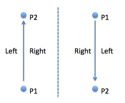
leftPlate and rightPlate point to the plates on either side of the plate boundary. Note that in this context, "left" specifically refers to the left hand side from the perspective of an observer travelling through the geometry of the object. This means "left" is entirely dependent on the order in which the points that comprise the geometry of the plate boundary were digitised. That is to say, if the plate boundary was digitised with the first point being in the South, and the last point being to the North, then the "left" is the plate to the West. If on the other hand, the exact same plate boundary were digitised with the first point being in the North, and the last point in the South, then the "left" plate is to the East. See diagram below.
The plate boundary itself will be given a reconstructionPlateId, which will likely correspond to a plate on one side of the plate boundary. conjugatePlateId is used to track a plate on the opposite side of the plate boundary.
Several plates may border a plate boundary on one side. It may be necessary for dynamic polygon closure to split all plate boundaries into pieces in order to avoid this. Otherwise, the choice of leftPlate and rightPlate is somewhat arbitrary. A good rule of thumb may be to use the plate which takes up the largest percentage of the boundary on the side.
2.2.2. ContinentalRift and MidOceanRidge
The ContinentalRift and MidOceanRidge features contain another property:
which specifies as of the present if the rift/ridge is actively spreading (isActive = True), or the rift/ridge is no longer spreading (isActive = False).
2.2.3. Transform
The Transform feature is used to model strike-slip plate boundaries, and so has an additional property:
which specifies whether the motion of the boundary is dextral (right lateral) or sinistral (left lateral).
2.2.4. SubductionZone
The following property is used by the SubductionZone feature:
The subductingSlab property specifies on which side of the SubductionZone is the slab that is being subducted into the mantle. It takes a value of "left" or "right". Note that in this context, "left" specifically refers to the left hand side from the perspective of an observer travelling through the geometry of the object. This means "left" is entirely dependent on the order in which the points that comprise the geometry of the plate boundary were digitised. That is to say, if the plate boundary was digitised with the first point being in the South, and the last point being to the North, then the "left" is the plate to the West. If on the other hand, the exact same plate boundary were digitised with the first point being in the North, and the last point in the South, then the "left" plate is to the East. See diagram below.
2.3. Geological Planes and Common Properties
GPlates also contains a number of features designed to model various types of geological planes, units, and contacts.
BasicRockUnit can be used to model any unit of rock, Fault can be used to model faults, FoldPlane can be used to model a fold axis plane, GeologicalPlane can be used to model bedding/cleavage planes, Unconformity can be used to model the planes of unconformities, and UnknownContact can be used a general "catch all" feature.
The "strike" of the geological plane should be contained in the centerLineOf property. Topographical representation of the plane could be stored in unclassifiedGeometry.
2.3.1. Common Properties
All "geological plane" features have the following common properties:
dipAngle is the angle of the "dip" of the plane in degrees below the horizontal, while dipSide is the side (left or right) to which the plane dips. Note that again "left" and "right" are determined by the direction in which the geometry of the plane is defined — if the line points North, left is to the West; if the same line points South, left is to the East.
leftUnit and rightUnit in the future could be used to point to BasicRockUnits on either side of the plane, but currently these properties are not enabled.
2.3.2. Faults
A Fault has the following additional properties:
dipSlip specifies if the fault has a dip component or not, and if so whether it is a normal or reverse fault. strikeSlip specifies if the fault has a strike component or not, and if so, whether it is dextral or sinistral. primarySlipComponent specifies which of the two components, if any, is the larger.
2.3.3. Folds
A FoldPlane also has the the additional property:
which specifies whether the fold is a syncline or anticline.
2.3.4. Bedding/Cleavage Planes
A GeologicalPlane is used to store information for geological planes such as bedding and cleavage planes, for example. The specific type (ie "Bedding" or "Cleavage") can be stored in the subcategory property.
2.4. Other Physical Features and Common Properties
Other physical GPlates features are listed below:
Basin, Craton, LargeIgneousProvince, Volcano, Seamount, and Suture are features with no unique properties. The user can use the subcategory property to further classify these features. For example, a Seamount can be classified as either a "seamount" or a "guyot".
2.4.1. Isochrons
An Isochron has the following unique properties:
These properties are used for keeping track of the conjugate isochron on the opposite side of the spreading ridge. Multiple instances of these properties can be added to keep track of multiple sections of the conjugate. conjugate points to a conjugate isochron feature, while conjugatePlateId refers to the plateId that associated it.
2.4.2. Hotspots and Hotspot Trails
A HotSpot has the unique property
which references the HotSpotTrail to which the HotSpot is associated.
2.4.3. Island Arcs
An IslandArc has the unique property:
to specify whether the island arc is currently being generated by subduction.
2.5. Abstract Fields
The features above are designed to store "abstract field" field, such oceanic seafloor depth (bathymetry), topography, dynamic topography, etc. In the current version of GPlates, data regarding these features can be stored as contour lines, for example, a contour line indicating a seafloor depth of 4000m could be stored as a Bathymetry feature.
In a future version of GPlates, it is intended to provide support for gridded (raster) data for these features.
3. GPlates File Format
3.1. Overview
GPlates stores its data in its own proprietary file format called GPlates Markup Language, or GPML. GPML is based on Geography Markup Language (GML), which is in turn based on eXtensible Markup Language (XML).
3.2. XML
XML is a set of rules for encoding documents electronically. Data is encoded in plain-text, as elements in between "tags", which effectively define the purpose of the element. An XML document can often be read simply in a text editor. Because the meaning of each piece of data is stored with the data, an XML document can often be very easy to interpret.
Below is an example XML document creating a "note" object, to "Bob" from "Bill". You can see the data portion of the "subject" element, for example, inbetween the "<subject" and "</subject>" tags.
<?xml version="1.0" encoding='UTF-8'?>
<note>
   <to>Bob</to>
   <from>Bill</from>
   <subject>The subject of the note.</subject>
   <body>This is an XML representation of a note from Bill to Bob.</body>
</note>
3.3. GML
GML is a grammar based on XML with the purpose of defining a framework for describing geographic objects. GML provides a number of geometry elements and tools such as feature relationships to create features in geographic models. The standardization of GML allows different GIS applications to communicate with each other in the same language.
An example GML geometry element is provided below. The example is a line which forms a square with the coordinates (0,0), (1,0), (1,1) and (0,1).
<?xml version="1.0" encoding='UTF-8'?>
<gml:LineString srsName="#myrefsys">
   <gml:posList dimension="2">0 0 1 0 1 1 0 1 0 0</gml:posList>
</gml:LineString>
3.4. GPML
GML provides built-in geometries and other elements for describing geographic objects. GPML contains a series of new features built based on GML structure to describe geographic features that may be useful in plate tectonic reconstructions. A GPML feature will consist of several GML properties such as name, description, and a GML geometry such as Point, LineString, or Polygon, and also several properties unique to GPML. For example, a MidOceanRidge feature in GPML will have an isActive property, which specifies whether the ridge is actively spreading or if it has become inactive.
An example of a GPML file produced by GPlates is provided below. The file consists of a single feature, the famous Nakata Isochron. The GML geometry for LineString can be seen in the gpml:centerLineOf property.
<?xml version="1.0" encoding="UTF-8"?>

<gpml:FeatureCollection xsi:schemaLocation=     "http://www.gplates.org/gplates ../xsd/gpml.xsd
                                                        http://www.opengis.net/gml ../../../gml/current/base/gml.xsd"
                                xmlns:gpml="http://www.gplates.org/gplates"
                                xmlns:gml="http://www.opengis.net/gml"
                                xmlns:xsi="http://www.w3.org/2001/XMLSchema-instance">
  <gml:featureMember>
    <gpml:Isochron>
      <gml:metaDataProperty>
        <CaltechMetaData>It's an Isochron</CaltechMetaData>
      </gml:metaDataProperty>
      <gml:description>CARLSBERG RIDGE, INDIA-AFRICA ANOMALY 5 ISOCHRON</gml:description>
      <gml:name codeSpace="urn:gplates:EarthByte">Nakata Isochron</gml:name>

      <gpml:identity>GPlates-1163390205.0-jboyden.aurora.28095</gpml:identity>
      <gpml:revision>GPlates-1163390205.4-jboyden.aurora.28095</gpml:revision>
      <gpml:supersededRevision>GPlates-1163390205.1-jboyden.aurora.9528</gpml:supersededRevision>
      <gpml:supersededRevision>GPlates-1163390205.2-jboyden.aurora.9528</gpml:supersededRevision>
      <gpml:supersededRevision>GPlates-1163390205.1-jclark.polygon.3287</gpml:supersededRevision>
      <gpml:supersededRevision>GPlates-1163390205.3-jboyden.aurora.28095</gpml:supersededRevision>
      <gpml:oldPlatesHeader>
            <gpml:OldPlatesHeader>
              <gpml:regionNumber>11</gpml:regionNumber>
              <gpml:referenceNumber>22</gpml:referenceNumber>
              <gpml:stringNumber>3333</gpml:stringNumber>
              <gpml:geographicDescription>CARLSBERG RIDGE</gpml:geographicDescription>
              <gpml:plateIdNumber>501</gpml:plateIdNumber>
              <gpml:ageOfAppearance>00010.9</gpml:ageOfAppearance>
              <gpml:ageOfDisappearance>999.0</gpml:ageOfDisappearance>
              <gpml:dataTypeCode>IS</gpml:dataTypeCode>
              <gpml:dataTypeCodeNumber>4444</gpml:dataTypeCodeNumber>
              <gpml:dataTypeCodeNumberAdditional>Z</gpml:dataTypeCodeNumberAdditional>
              <gpml:conjugatePlateIdNumber>502</gpml:conjugatePlateIdNumber>
              <gpml:colourCode>078</gpml:colourCode>
              <gpml:numberOfPoints>2</gpml:numberOfPoints>
            </gpml:OldPlatesHeader>
      </gpml:oldPlatesHeader>
      <!-- gpml:subcategory -->

      <gpml:validTime>
            <gml:TimePeriod>
              <gml:begin>
                    <gml:TimeInstant>
                      <gml:timePosition frame="http://gplates.org/TRS/flat">10.9</gml:timePosition>
                    </gml:TimeInstant>
              </gml:begin>
              <gml:end>
                    <gml:TimeInstant>
                      <gml:timePosition frame="http://gplates.org/TRS/flat">http://gplates.org/times/distantFuture</gml:timePosition>
                    </gml:TimeInstant>
              </gml:end>
            </gml:TimePeriod>
      </gpml:validTime>
      <gpml:reconstructionPlateId>
            <gpml:ConstantValue>
              <gpml:valueType>gpml:plateId</gpml:valueType>
              <gpml:value>501</gpml:value>
            </gpml:ConstantValue>
      </gpml:reconstructionPlateId>
      <!-- gpml:truncatedSections -->

      <gpml:conjugate>
            <gpml:FeatureReference>
              <gpml:valueType>gpml:Isochron</gpml:valueType>
              <gpml:targetFeature>GPlates-1163486717.5-jboyden.aurora.28095</gpml:targetFeature>
            </gpml:FeatureReference>
      </gpml:conjugate>
      <gpml:conjugatePlateId>502</gpml:conjugatePlateId>
      <gpml:centerLineOf>
            <gpml:ConstantValue>
              <gpml:valueType>gml:OrientableCurve</gpml:valueType>
              <gpml:value>
                    <gml:OrientableCurve orientation="+">
                      <gml:baseCurve>
                            <gml:LineString>            <!-- srsName needs looking into -->
                              <gml:posList srsName="WGS84" srsDimension="2">89.95 71.66 45.33 70.80</gml:posList>
                            </gml:LineString>
                      </gml:baseCurve>
                    </gml:OrientableCurve>
              </gpml:value>
            </gpml:ConstantValue>
      </gpml:centerLineOf>

    </gpml:Isochron>
  </gml:featureMember>
</gpml:FeatureCollection>
4. Converting From Other File Formats
GPlates is able to read and write in a diverse set of file formats. The primary issue when converting file formats is the information that is stored under each file format. For example, Shapefiles produced from ArcGIS contain the geometry of features, and the metadata in these files can be used to store important information such as beginning/ending time, however, in general they do not store a lot of important information that GPlates expects to have. This is because ArcGIS is a more general GIS modeling tool that is not designed specifically for plate tectonics. On the other hand, PLATES4 was a program designed for a similar purpose as GPlates, and contains much data that GPlates finds useful, however, not all GPlates properties will be populated by a PLATES program.
4.1. Shapefiles
Shapefiles are a popular data format for geographic information software. GPlates is able to read in shapefiles given that certain conditions are met.
A shapefile is a digital storage format for storing geometric location data and associated attributes. It can store primitive geometrical data types of points, lines and polygons. A shapefile actually consists of several files: the .shp which contains the feature geometry, the .shx index file, and the .dbf file for storing attribute data. GPlates needs all three in order to properly read a shapefile.
GPlates reads in the geometry of the feature from the .shp file. When GPlates reads a shapefile, it assumes that the (x,y) coordinates in the shapefile are in the format (latitude, longitude), in degrees from -90 to 90 for latitude and -180 to +180 for longitude.
GPlates can also read in other information from the attribute information, but because attributes can be named anything in a shapefile, GPlates needs to know what exactly to look for. This is dealt with in Chapter 12 of the GPlates User Documentation.
4.2. PLATES Files
PLATES is an older software with a similar design to GPlates. It is useful for GPlates to be able to read PLATES files, partly because of the information stored in these input files, but also due to the legacy software programs that use PLATES files as input. GPlates data can be converted into PLATES data in order to make use of these programs.
PLATES files come with the following header information for each feature. GPlates stores the entire header (in the oldPlatesHeader property), but does not actually use most of it.
-
regionNumber (2 digit integer)
-
referenceNumber (2 digit integer)
-
stringNumber (4 digit integer)
-
geographicDescription(ASCII string, no specified length)
-
plateIdNumber (3 digit integer)
-
ageOfAppearance (6 char, 1 double precision floating point number, in Ma)
-
ageOfDisappearance (6 char, 1 double precision floating point number, in Ma)
-
dataTypeCode (ASCII string, 2 characters)
-
dataTypeCodeNumber (4 digit integer)
-
dataTypecodeNumberAdditional (1 character)
-
conjugatePlateIdNumber (3 digit integer)
-
colourCode (3 digit integer)
-
numberOfPoints (5 digit integer)
geographicDescription is used to populate name. plateIDnumber is used to populate reconstructionPlateId. ageOfAppearance and ageOfDisappearance are used to populate gml:validTime. For appropriate feature types, such as Isochron, conjugatePlateIdNumber is used to populate conjugatePlateId.
dataTypeCode is a two character code that is used to specify the type of feature. GPlates maps this code to GPlates feature types using the table below:
PLATES Code |
GPlates Data Type |
AR |
AseismicRidge |
BA |
Bathymetry |
BS |
Basin |
CB |
PassiveContinentalBoundary |
CF |
ContinentalFragment |
CM |
PassiveContinentalBoundary |
CO |
PassiveContinentalBoundary |
CR |
Craton |
CS |
Coastline |
EC |
ExtendedContinentalCrust |
FT |
Fault |
GR |
OldPlatesGridMark |
GV |
Gravimetry |
HF |
HeatFlow |
HS |
HotSpot |
HT |
HotSpotTrail |
IA |
IslandArc (.isActive == true) |
IC |
Isochron |
IM |
Isochron |
IP |
SedimentThickness |
IR |
IslandArc (.isActive == false) |
LI |
GeologicalLineation |
MA |
Magnetics |
NF |
Fault (.dipSlip == "Extension") |
OB |
OrogenicBelt |
OP |
BasicRockUnit (.subcategory == "Ophiolite") |
PB |
InferredPaleoBoundary |
PC |
MagneticAnomalyIdentification |
PM |
MagneticAnomalyIdentification |
RA |
IslandArc (.isActive == false) |
RF |
Fault (.dipSlip == "Compression") |
SM |
Seamount |
SS |
Fault |
SU |
Suture |
TB |
TerraneBoundary |
TC |
TransitionalCrust |
TF |
Transform |
TH |
Fault |
TO |
Topography |
TR |
SubductionZone (.isActive == true) |
UN |
UnclassifiedFeature |
VO |
Volcano |
VP |
LargeIgneousProvince |
XR |
MidOceanRidge (.isActive == false) |
XT |
SubductionZone (.isActive == false) |
5. Appendix: GPlates Features and Properties Tables
Feature |
Properties |
Description |
A nonspecific, inactive ridge. Use a MidOceanRidge with "isActive" = False instead of this to model an inactive mid-ocean spreading ridge. |
||
A geological rock unit. May be used to describe one side of a GeologicalPlane. |
||
A regional scale depression of erosional or structural origin. As there are many different types of basin ("extensional", "convergent", "thermal", etc.), the subcategory property can be used to distinguish between these types. |
||
This feature can currently be used to model bathymetric (seafloor depth) contour lines. A future release of GPlates may provide support for gridded data. |
||
type |
A closed polygon boundary between continental and oceanic crust. Used in the process of creating and exporting polygons. |
|
A closed polygon made up of a series of plate boundaries. Used in the process of creating and exporting polygons. |
||
Used to model present day and paleo- coastlines. |
||
A continental rift. isActive is used to distinguish between active and inactive ridges. leftPlate, rightPlate and conjugatePlateId are used to identify the plates on either side of the ridge. |
||
A large portion of a continental plate that has been relatively undisturbed since the Precambrian era, and includes both shield and platform layers. |
||
This feature can currently be used to model contours of constant crustal thickness. A future release may provide support for gridded data. |
||
This feature can currently be used to model dynamic topography contour lines. A future release may provide support for gridded data. |
||
Used to model areas of extended continental crust, for example along continental slopes. |
||
leftUnit rightUnit |
A fracture in a rock body, along which observable relative displacement has occurred between adjacent blocks. centerLineOf (the strike), dipAngle and dipSide are used to track the orientation of the fault plane, strikeSlip and dipSlip are used to track the magnitude of the displacement in meters, and leftUnit and rightUnit can be used to refer to BasicRockUnit features to either side of the fault. Finally, primarySlipComponent can be set to "StrikeSlip", "DipSlip", "None", or "Unknown" to specify which component of displacement (strike or dip) is larger. |
|
Inferred plane of geological folding. centerLineOf (the strike), dipAngle and dipSide specify the orientation of the plane while foldAnnotation specifies whether the fold is a syncline or an anticline. |
||
An inactive fracture in the crust that was once part of a transform boundary. |
||
A point used to take readings in order to determine the relative age of a position on a fracture zone. |
||
A catch-all for miscellaneous geological lineations. |
||
A surface plane indicator based on rock unit observations, for example, bedding and cleavage planes. The user can use the subcategory property to distinguish between the different types of planes. centerLineOf (the strike), dipAngle and dipSide are used to specify the orientation of the plane. |
||
This feature can currently be used to model both bathymetric and topographic contour lines. A future release of GPlates may provide support for gridded data. |
||
This feature can currently be used to model gravimetric contour lines. A future release of GPlates may provide support for gridded data. |
||
This feature can currently be used to model heatflow contour lines. A future release of GPlates may provide support for gridded data. |
||
trail |
The present-day surface expression of a mantle plume. The trail property is used to point to the HotSpotTrail feature that this HotSpot is associated with. |
|
mark evidence |
A line representing a trail of a hotspot. In a future version of GPlates, the user will be able to create multiple evidence properties to point to pieces of evidence of a HotSpotTrail, such as volcanoes and seamounts. errorBounds is a geometry property that can be used to express uncertainty about the exact location of the trail — it is an unclassified geometry so it can either be a line or polygon. The mark property in GPGIM 1.5 is not functional. |
|
A part of plate boundary for real-world geology that no longer exists, such as the boundary between India and Asia that has since been subducted under the Himalaya. |
||
A volcanic arc that is formed from magma rising from a subducting oceanic plate. |
||
conjugate |
A line defining points of equal age for oceanic crust. The age of the isochron can be stored in its validTime.begin property. The user can create multiple conjugate and conjugatePlateId properties to refer to the conjugate(s) of this isochron and the plate(s) that the conjugates(s) are located on. |
|
An extensive region of basalts resulting from flood basalt volcanism. |
||
|
shipTrack |
A point used to take readings in order to determine the relative age of a position on a polarity chron. polarityChronId specifies the name of the polarity chron upon which readings are being taken, polarityChronOffset specifies the relative location on the chron, from 0.0 (youngest) to 1.0 (oldest). In a future version of GPlates, shipTrack could be used to reference the ship track upon which measurements were taken. |
|
pick |
The map-view path taken by a particular ship for magnetic anomaly data. |
|
This feature can currently be used to model magnetic contour lines. A future release of GPlates may provide support for gridded data. |
||
This feature can currently be used to model mantle density contour lines. A future release of GPlates may provide support for gridded data. |
||
A mid ocean ridge. isActive is used to distinguish between active and inactive ridges. leftPlate, rightPlate and conjugatePlateId are used to identify the plates on either side of the ridge. |
||
This feature can currently be used to model oceanic age contour lines. A future release of GPlates may provide support for gridded data. Until then it is probably best to use the Isochron feature. |
||
This is feature that is specifically created to provide backwards compatibility with the PLATES "GR" code. |
||
A zone on a regional scale which has undergone compressional tectonics. The subductingSlab property is used to specify which side of the orogenic belt is the slab which is being subducted into the mantle. |
||
A passive continental boundary, indicating the change between continental and oceanic crust. Since this change is broad and hard to pin down, we expect to have two types of passive continental boundaries, "inner" (closer to the continent) and "outer" (closer to the ocean). This type of boundary is defined by the edge property. continentalSide specifies which side of the boundary the continental crust is on. |
||
A pseudofault is a now inactive fault that formed as a result of ridge propagation. |
||
This feature can currently be used to model roughness contour lines. A future release of GPlates may provide support for gridded data. |
||
A mountain below sea level, formerly a volcano. The subcategory property can be used to distinguish between seamounts and guyots. |
||
This feature can currently be used to model isopach lines for sediment thickness. A future release of GPlates may provide support for gridded data. |
||
This feature can currently be used to model spreading asymmetry rate lines. A future release of GPlates may provide support for gridded data. |
||
This feature can currently be used to model stress lines. A future release of GPlates may provide support for gridded data. |
||
|
islandArc |
A subduction zone. leftPlate and rightPlate are used to identify plates on either side of the ridge, subductingSlab is used to point to the plate that is being subducted into the mantle, and islandArc is used to point to any IslandArc features that are associated with the subduction zone. |
|
A large-scale structural feature associated with continental collision, defining a paleo plate boundary. |
||
A terrane boundary. |
||
This feature can currently be used to model topographic contour lines. A future release of GPlates may provide support for gridded data. |
||
Used in GPlates internally to identify closed plate boundaries. |
||
A strike-slip plate boundary. |
||
Used to a identify regions of transition between oceanic and continental crust. |
||
A catch-all for any unclassified features. |
||
|
leftUnit rightUnit |
A contact plane between two rock units. centerLineOf (the strike), dipAngle and dipSide can be used to specify the orientation of the contact, while leftUnit and rightUnit can be used to refer to the BasicRockUnit features on either side of the contact. |
|
|
leftUnit rightUnit |
An unknown geological contact line. centerLineOf (the strike), dipAngle and dipSide can be used to specify the orientation of the contact, while leftUnit and rightUnit can be used to refer to the BasicRockUnit features on either side of the contact. |
|
A volcano. |
Property |
Optionality |
Used In |
Description |
Required |
GPlates internally |
Used internally by GPlates. |
|
Required |
Used internally by GPlates to point to individual plate boundaries that are combined to comprise closed plate boundary polygons. |
||
Optional |
Features with line geometry. |
When a feature’s geometry is best described by a line, it is best to use the centreLineOf property. |
|
Multiple Optional |
Refers to the plate on the opposite side of the plate boundary. At creation, a plate boundary will be assigned a reconstructionPlateId, which is effectively the plate that the boundary "belongs to". The conjugate plate is the plate on the opposite side of the boundary from this plate. In the case of the Isochron feature, a conjugate plate is the plate that the Isochron's conjugate is associated with. |
||
Optional |
Indicates which side of the boundary is the continental side. Takes a value of "Left", "Right", and "Unknown". Note that in this context, "left" specifically refers to the left hand side from the perspective of an observer travelling through the geometry of the object. This means "left" is entirely dependent on the order in which the points that comprise the geometry of the plate boundary were digitised. That is to say, if the plate boundary was digitised with the first point being in the South, and the last point being to the North, then the "left" is the plate to the West. If on the other hand, the exact same plate boundary were digitised with the first point being in the North, and the last point in the South, then the "left" plate is to the East. |
||
Optional |
All |
A description of the feature in string format. |
|
Optional |
Used to describe the angle a surface "dips" from the horizontal, usually in degrees. The complete orientation of the plane is the strike (stored in the centerLineOf geometry property), the dip angle (stored in this property), and the dip direction (stored in the dipSide property). |
||
Optional |
Used to specify the dip direction of the plane. The complete orientation of the plane is the strike (stored in the centerLineOf geometry property), the dip angle (stored in the dipAngle property), and the dip direction (stored in this property). The dipSide is stored as "Left", "Right", "Undefined", or "Unknown". "Undefined" is appropriate when the dip angle is 90 degrees or completely vertical, meaning it does not dip to either the left or right. Note that in this context, "left" specifically refers to the left hand side from the perspective of an observer travelling through the geometry of the object. This means "left" is entirely dependent on the order in which the points that comprise the geometry of the plane were digitised. That is to say, if the plane was digitised with the first point being in the South, and the last point being to the North, then "left" is to the West. If on the other hand, the exact same plane were digitised with the first point being in the North, and the last point in the South, then "left" is to the East. |
||
Optional |
Used to specify whether the fault is "Extentional" (a normal fault), "Compression" (a reverse fault), "None" (there is no movement along the dip of the fault, or "Unknown". |
||
Optional |
Because a passive continental boundary often tends to be broad and hard to pin down, it is expected that users may wish to distinguish between an "inner" and "outer" passive continental boundary. The property is used to indicate whether the feature is an "inner" continental boundary, meaning the edge of the continental boundary that is closer to the center of continetal crust, or an "outer" continental boundary, meaning the edge of the continental boundary that is farthest away from the center of continental crust. |
||
Optional |
This property is not currently used in GPlates. In a future version it could be used to specify an area of uncertainty with respect to a location of a feature. |
||
Optional |
Used to specify whether a fold is a "Syncline", "Anticline", "None", or "Unknown". |
||
Optional |
Used to determine if the feature is "active" or not. In the case of MidOceanRidge and ContinentalRift, isActive should be "True" if the ridge is actively spreading, and "False" otherwise. In the case of IslandArc, isActive is "True" if the IslandArc is in the process of being created via subduction, and "False" otherwise. Note that isActive is potentially able to specify a time period for activity/inactivity, but in the GPGIM 1.5 this value is currently limited to a simple true/false. |
||
Optional, required for dynamic polygon closure |
Refers to the plate on the "left" side of the plate boundary. Strictly speaking, this is an optional feature with the purpose of , however GPlates does make use of it in the dynamic polygon closure algorithm. Note that in this context, "left" specifically refers to the left hand side from the perspective of an observer travelling through the geometry of the object. This means "left" is entirely dependent on the order in which the points that comprise the geometry of the plate boundary were digitised. That is to say, if the plate boundary was digitised with the first point being in the South, and the last point being to the North, then the "left" is the plate to the West. If on the other hand, the exact same plate boundary were digitised with the first point being in the North, and the last point in the South, then the "left" plate is to the East. See diagram below. image::leftRight.png If there is more than one plate to the left of the boundary, it may be necessary for the use of dynamic polygon closure to break the boundary into pieces. Otherwise, the choice of which plate to use is arbitrary, however, the plate which shares the larger area of the boundary at the present time may be the most descriptive plate to use. |
||
Optional |
Used to specify whether a transform or strike-slip boundary is "LeftLateral" (sinistral — when viewed from one side of the boundary, the opposite side appears to be moving to observer’s left), or "RightLateral" (dextral — the opposite side appears to be moving to the observer’s right). It can also take a value of "Unknown" or "None". |
||
Optional |
All |
A descriptive name of the feature in string format. |
|
Optional |
All |
If the original files came with PLATES header info, this information is preserved in this property, otherwise this property is blank. The property itself consists of several elements: * regionNumber (2 digit integer) * referenceNumber (2 digit integer) * stringNumber (4 digit integer) * geographicDescription(ASCII string]] * regionNumber (2 digit integer) * referenceNumber (2 digit integer) * stringNumber (4 digit integer) * geographicDescription(ASCII string, no specified length) * plateIdNumber (3 digit integer) * ageOfAppearance (6 char, 1 double precision floating point umber, n Ma) * ageOfDisappearance (6 char, 1 double precision floating point number, in Ma) * dataTypeCode (ASCII string, 2 characters) * dataTypeCodeNumber (4 digit integer) * dataTypecodeNumberAdditional (1 character) * conjugatePlateIdNumber (3 digit integer) * colourCode (3 digit integer) * numberOfPoints (5 digit integer) |
|
Optional |
Features with polygon geometry. |
When a feature’s geometry is best described by a polygon, it is usually appropriate to use the outlineOf geometry. |
|
Optional |
FractureZoneIdentification |
The string name of the polarity chron based on the geomagnetic reversal timescale. |
|
Optional |
Specifies the location on the polarity chron, from youngest to oldest. Takes a value of 0.0 to 1.0, where 0.0 is the youngest edge of the chron, and 1.0 is the oldest edge of the chron. |
||
Required |
Features with point geometry. |
When a feature’s geometry is described as a point, it is appropriate to use the Point geometry. |
|
Optional |
For faults with both dip-slip and strike-slip motion, this property is used to specify whether the dip-slip or strike-slip component of motion is larger. Takes the value "StrikeSlip" if the strike-slip component of motion is greater, "DipSlip" if the dip-slip component is greater, "None" if there is no dominant component, or "Unknown". |
||
Optional |
GPlates internally |
This is used by GPlates internally to store the feature’s original plateId for reconstructions in a snapshot. |
|
Optional |
GPlates internally |
This is used by GPlates internally to store the feature’s time in a snapshot. |
|
Required |
All reconstructable properties. |
The plateID that will be used for reconstruction purposes. |
|
Optional, required for dynamic polygon closure |
Refers to the plate on the "right" side of the plate boundary. Strictly speaking, this is an optional feature with the purpose of , however GPlates does make use of it in the dynamic polygon closure algorithm. Note that in this context, "right" specifically refers to the right hand side from the perspective of an observer travelling through the geometry of the object. This means "right" is entirely dependent on the order in which the points that comprise the geometry of the plate boundary were digitised. That is to say, if the plate boundary was digitised with the first point being in the South, and the last point being to the North, then the "right" is the plate to the West. If on the other hand, the exact same plate boundary were digitised with the first point being in the North, and the last point in the South, then the "right" plate is to the East. See diagram below. image::leftRight.png If there is more than one plate to the right of the boundary, it may be necessary for dynamic polygon closure to break the boundary into pieces. Otherwise, the choice of which plate to use is arbitrary, however, the plate which shares the larger area of the boundary at the present time may be the most descriptive plate to use. |
||
Optional |
Used to specify the motion along the strike of a fault. Takes a value of "LeftLateral" (also called sinistral), "RightLateral" (also called dextral), "Unknown" or "None". |
||
Optional, required for dynamic polygon closure |
Indicates the side of the plate boundary of the subducting slab (the slab that is being subducted into the mantle). Takes a value of "Left", "Right", or "Unknown". Note that in this context, "left" specifically refers to the left hand side from the perspective of an observer travelling through the geometry of the object. This means "left" is entirely dependent on the order in which the points that comprise the geometry of the plate boundary were digitised. That is to say, if the plate boundary was digitised with the first point being in the South, and the last point being to the North, then the "left" is the plate to the West. If on the other hand, the exact same plate boundary were digitised with the first point being in the North, and the last point in the South, then the "left" plate is to the East. See diagram below. image::leftRight.png |
||
Optional |
Any |
Any feature with a geometry that cannot be described with position, centerLineOf, or outLineOf. |
|
Optional |
All |
The period of time the feature is in existence. Consists of two variables, "begin" and "end", which are the points in time (in millions of years ago or Ma) in which the feature came in and out of existence respectively. "Begin" and "end" can also be set to "Distant Past" and "Distant Future" respectively. |