Christian Heine
EarthByte Group,
School of Geosciences
The University of Sydney, Australia
http://www.earthbyte.org/people/christian
Return to the EarthByte Resources index page.

The ICONS Atlas as represented by these webpages on the 'basinatlas.org' and 'earthbyte.org' domains is licensed under a Creative Commons
Attribution-ShareAlike 3.0 Unported License.
This atlas is a compilation of global crustal and lithospheric structure data for 242 intercontinental sedimentary basins. It is part of my PhD project investigating the formation and evolution of intracontinental basins and combines information about crustal structure, plate kinematics and mantle dynamics in one coherent HTML-based presentation. The aim is to provide quantitative constraints for next generation basin modeling approaches which integrate deep-earth dynamics, plate tectonics and lithospheric modeling.
The full version of the atlas uses a PostGIS geospatial database backend and a series of Python and XML based workflows to compute grids and tie plate tectonic data together with mantle convection models. All software tools used are open-source and utilise non-proprietary file formats.
The pages are optimised for standard-compliant browsers, such as Firefox, Netscape, Safari, Camino. The image quality in Internet Explorer especially on MS Windows is bad due to the rendering of resized PNG files. Firefox and Camino on Mac OS X (Intel Chip Macs) have problems displaying inline PDF documents in the browser. Camino will try to download a PDF to disk. A fix for this behaviour is to run both, Firefox or Camino, under Rosetta and use a PDF browser plug-in (Go to applications, select the browser application and click on 'Info' (or Apple+i) and check 'open using Rosetta').
↑ back to the topThe structure of the atlas is fairly simple: the globe is divided into several regions in which the basins are grouped (e.g. Australia). A regional overview page collects all information for the basins within that region. From there, a dropdown menu or a link in the basin overview table allows the user to access the individual basin pages with grids of higher resolution (2 min). Clicking the images will open a print-quality PDF of the same image (regional- and basin-scale maps).
The regional page and the methodology pages can be accessed directly through the dropdown menu. To display individual basin page, it is necessary to navigate to the regional overview and start from there. Alternatively, one can access the global basin overview.
The map below shows the global distributions of basins used in this study. Grey colours indicate
basin polygons in global basin data base, coloured basins indicate the ones selected for this study.
Colouring indicates region. Red lines indicate the position of generated
lithospheric-scale cross sections.
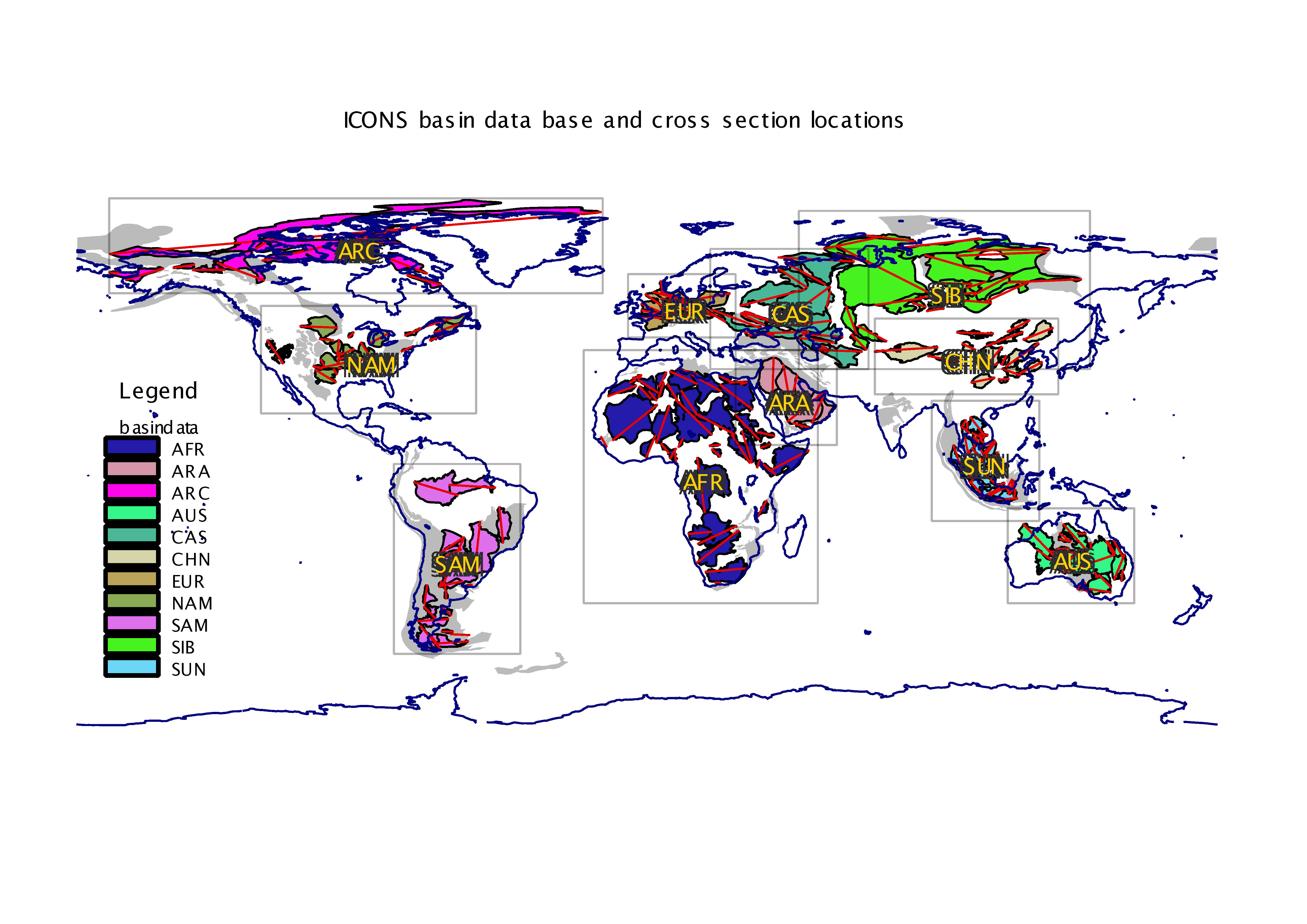
| Region code | Region | ID |
|---|---|---|
| AFR | Africa | 7 |
| ARA | Arabian Peninsula | 5 |
| ARC | North American Arctic | 1 |
| AUS | Australia | 8 |
| CAS | Caspian Region | 3 |
| CHN | China | 6 |
| EUR | Central Europe | 3 |
| NAM | North America | 1 |
| SAM | South America | 2 |
| SIB | Siberian region | 3 |
| SUN | Sundaland (Southeast Asia) | 6 |
This atlas makes use of the global crustal model CRUST2 and thermal lithosphere model TC1 (Artemieva, 2006) to construct differential extension and anomalous tectonic subsidence grids for a set of more than 240 basin polygons. Irena Artemieva is kindly acknowledged for providing us with her thermal lithosphere model
The dynamic topography computations are based on Bernhard Steinberger's models, the basin polygons were kindly supplied by Trond Torsvik. Both are at the Center of Geodynamics at the Norwegian Geological Survey (Trondheim). I am grateful to both of them for kindly providing access to their data.
↑ back to the top
The ICONS Atlas as represented by these webpages on the 'basinatlas.org' and 'earthbyte.org' domains is licensed under a Creative Commons
Attribution-ShareAlike 3.0 Unported License.