 We present a global community data set of fracture zones (FZs), discordant zones, propagating ridges, V-shaped structures and extinct ridges, digitized from vertical gravity gradient (VGG) maps.
We use a new semi-automatic FZ tracking program to test the precision of our hand-digitized traces and find a Mean Absolute Deviation of less than 3.4 km from the raw VGG minima that most clearly delineate each feature, and less than 5.4 km from the FZ location predicted by fitting model profiles to the VGG data that represent the morphology of the individual FZs. These offsets are small considering gravity data only provide an approximation for the underlying basement morphology. We further investigate the origin of non-FZ seafloor fabric by combining published abyssal hill heights computed from gravity anomalies with global half-spreading rates. A residual abyssal hill height grid, with spreading rate effects removed, combined with our interpreted tectonic fabric reveals several types of seafloor fabric distinct from typical abyssal hills. Where discordant zones do not overprint abyssal hill signals, residual abyssal hill height anomalies correspond to seafloor that accreted near mantle thermal anomalies or zones of melt-depletion. Our analysis reveals several areas where residual abyssal hill height anomalies reflect pseudo-faults and extinct ridges associated with ridge propagation and/or microplate formation in the southern Pacific Ocean.
This work was carried out as part of The Global Seafloor Fabric and Magnetic Lineation Data Base Project. The original data set is also stored in a continually maintained database, hosted by the GSFML website.
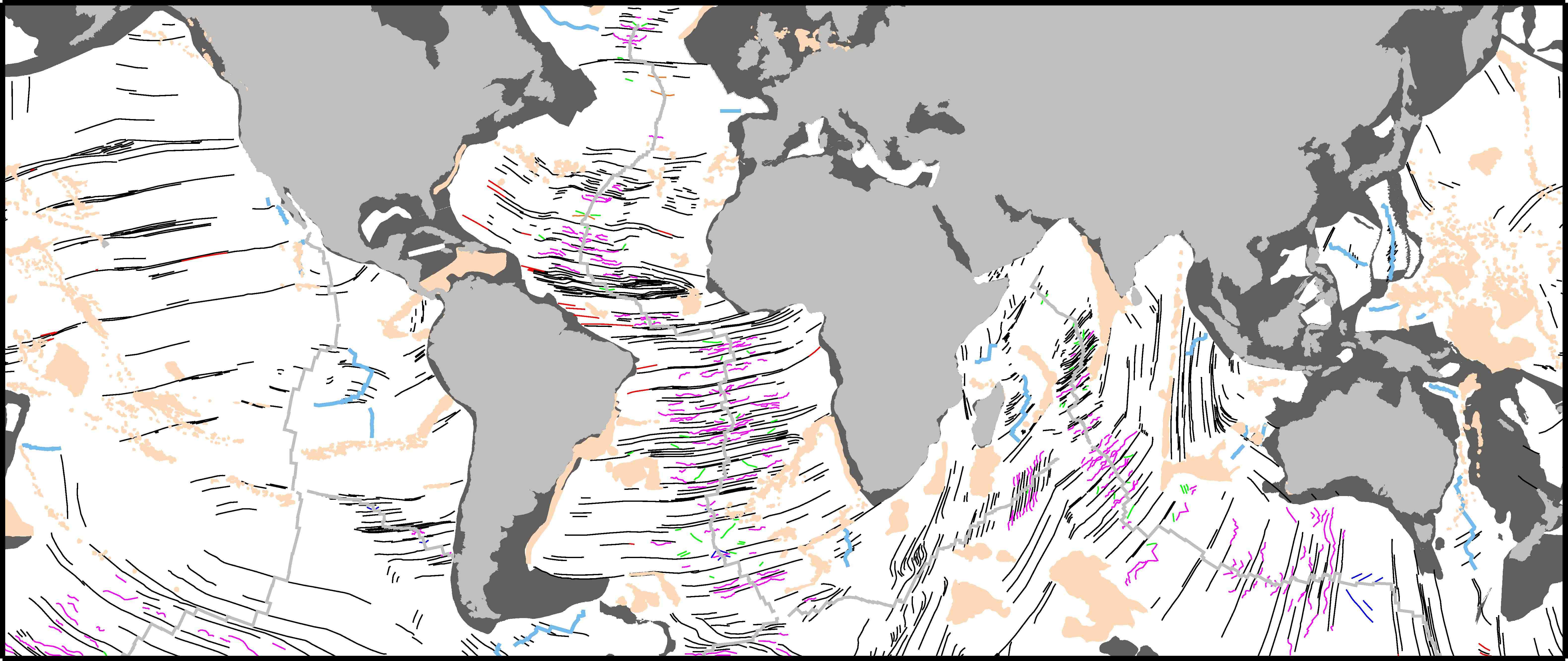
Figure caption: Tectonic fabric map of the ocean basins. Extinct spreading ridges are light blue, FZs are black, less clearly defined FZ traces are red, discordant zones are magenta, propagating ridge lineations are blue, and unclassified v-anomalies are green. Mid-ocean ridges (light grey) are from Sandwell and Smith (2009), large igneous provinces and seamount chains (light brown) are after Coffin and Eldholm (1994), and continental crust (grey shading) is from Müller et al. (2008). Click figure to obtain a high resolution image.
Download
JGR paper – pdf
Tectonic Fabric Traces (GPlates and Google Earth)
License
![]() This work is licensed under a Creative Commons Attribution 3.0 Unported License.
This work is licensed under a Creative Commons Attribution 3.0 Unported License.
![]()
