Lower-mantle iron heterogeneity constrained by the electrical conductivity of Al-bearing bridgmanite
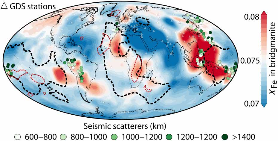
Map showing global iron content distribution in the lower mantle at 1225 kilometres depth with LLSVP boundaries outlined.

Scientists measured how well iron-bearing bridgmanite, the main mineral in Earth’s lower mantle, conducts electricity under high pressure and temperature conditions. They found conductivity rises sharply with iron content but barely changes with temperature, allowing iron variations to be mapped directly from global conductivity models derived from geomagnetic data. The results suggest iron-rich material within … Read more…
Impact of Cenozoic sea-level fluctuations on passive margin stratigraphic architecture: Implications for underground hydrogen storage potential

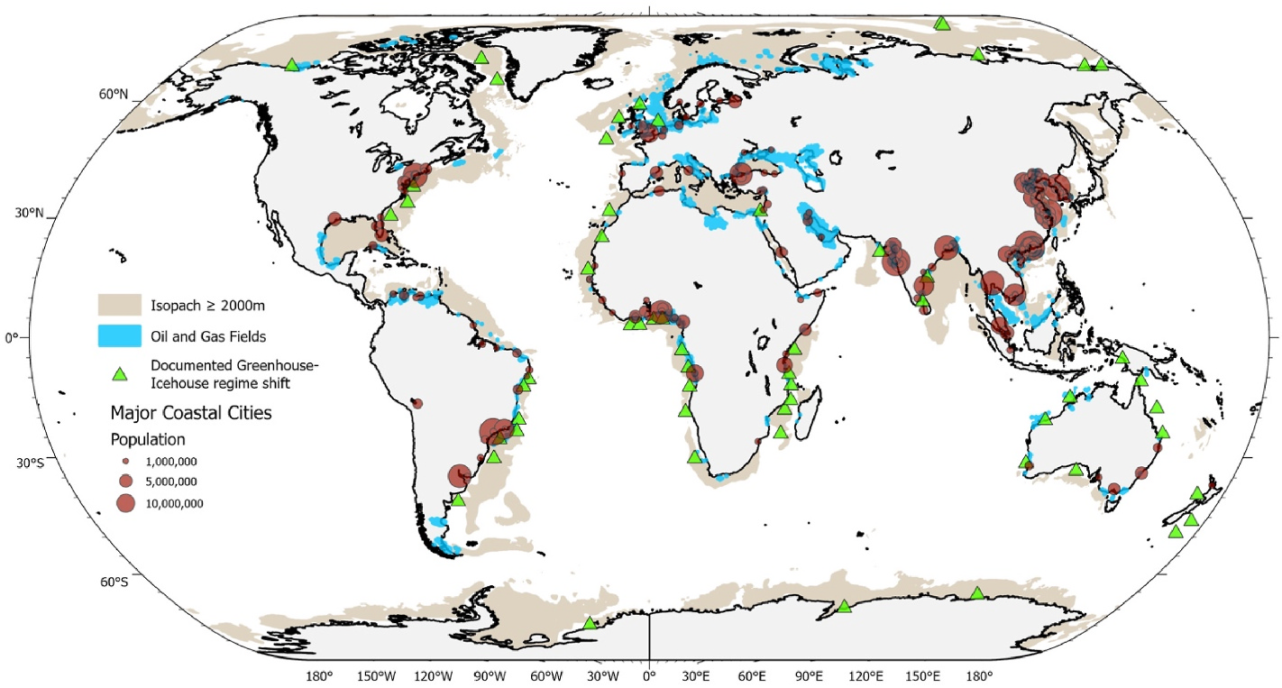
Global map showing passive margins with thick sedimentary successions and greenhouse–icehouse regime shifts relevant to hydrogen storage potential.

This study used forward stratigraphic modelling of the Hunter offshore margin in New South Wales to examine how Cenozoic sea-level changes shaped the layering of sediments on passive continental margins. The results show that warm 'greenhouse' periods produced thick, continuous sediment layers good for storing gases, while colder 'icehouse' periods produced thinner, stacked layers that … Read more…
Eastward Growth of the Tibetan Plateau Linked to Cenozoic Orogenic Wedge Deformation and Fluctuating Melt Sources

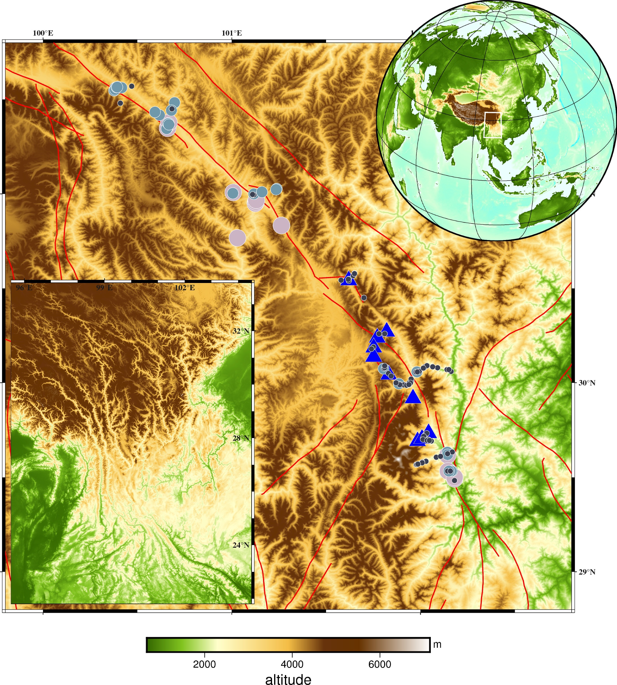
Digital elevation map of the southeastern Tibetan Plateau showing sample locations and major faults.

Scientists studied granitoids from the Kangding area in the southeastern Tibetan Plateau, using new elemental and isotopic data, including the first silicon isotope measurements for these rocks, to trace how the plateau’s crust grew eastward over the last 35 million years. The granites fall into two groups, and one of them shows a temporary shift … Read more…
Granitic intrusions enhance strain localization and rapid mantle exhumation along an oceanic detachment fault

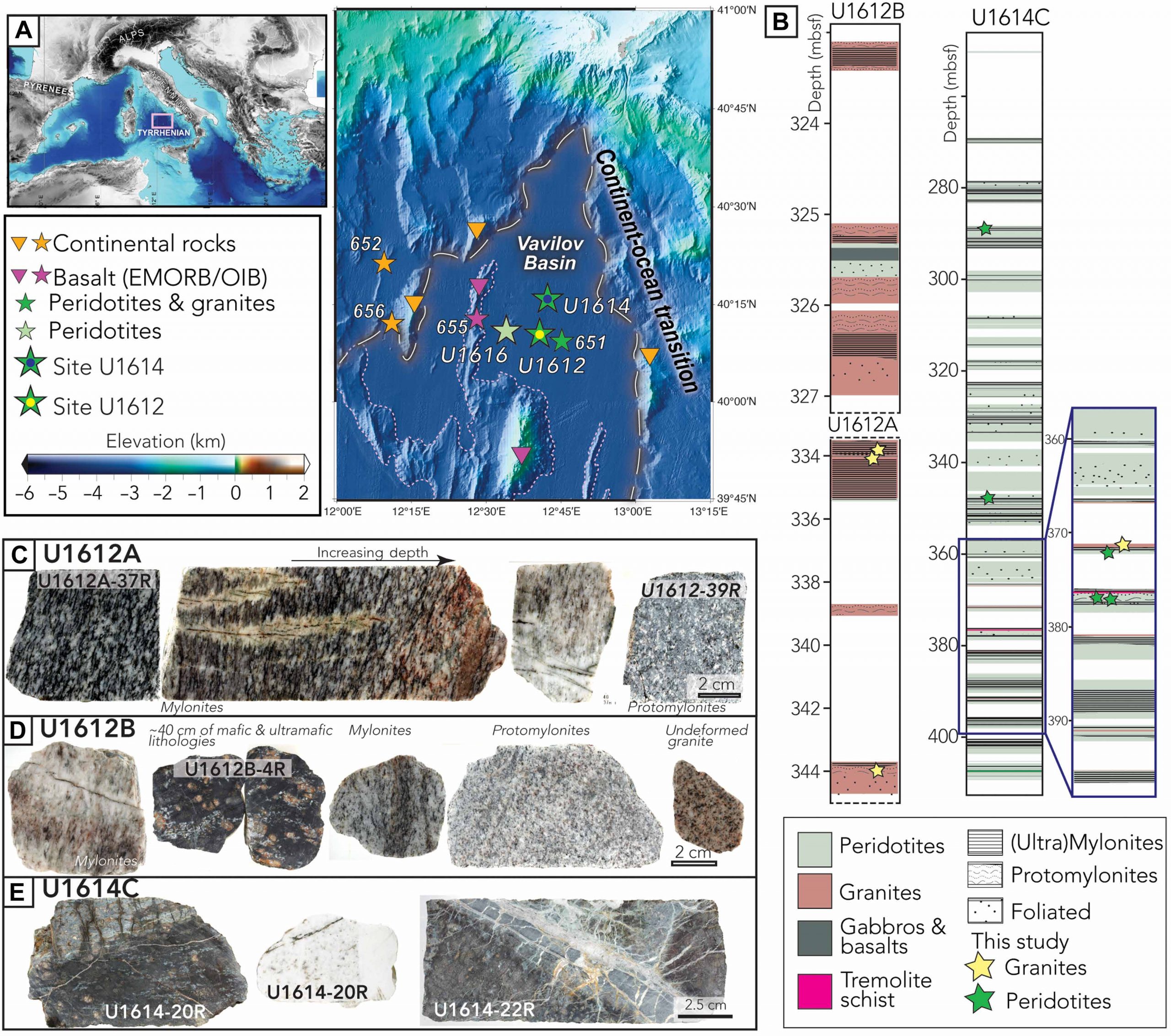
Map of the Tyrrhenian Sea showing IODP Expedition 402 drill sites with core photos and lithology logs.

Scientists drilling into the Tyrrhenian Sea seafloor as part of the International Ocean Discovery Program recovered rock cores showing granite intrusions mixed with peridotite along an ancient detachment fault. Dating and chemical analysis show the granites formed about 4 million years ago some 7 to 9 kilometres down, then were rapidly brought to the seafloor … Read more…
Coral thermal tolerances constrain extreme Mesozoic–Cenozoic hothouse reconstructions

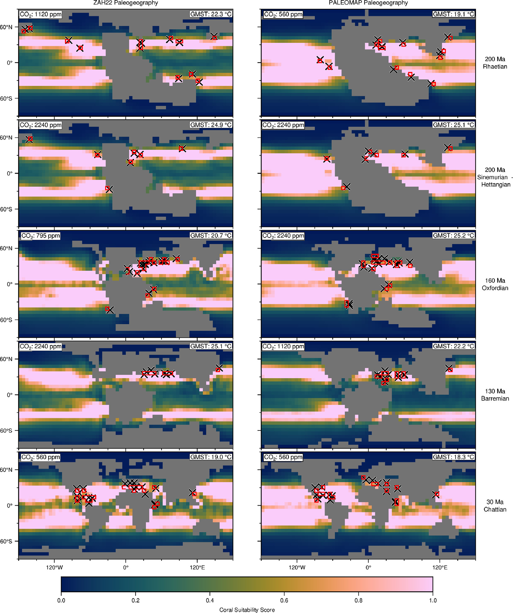
Maps comparing coral habitat suitability under two paleogeographic reconstructions, with fossil coral sites marked as crosses.

Modern reef-building corals only thrive within a narrow sea surface temperature range of about 22–30°C. The authors use this preference as an independent check on past climate models, running an ensemble of simulations from 250 million years ago to today across a range of CO2 levels and paleogeographies. Their coral-constrained temperature curve closely matches earlier … Read more…

Birth of the viru microplate triggered by Pacific-Farallon plate reorganization

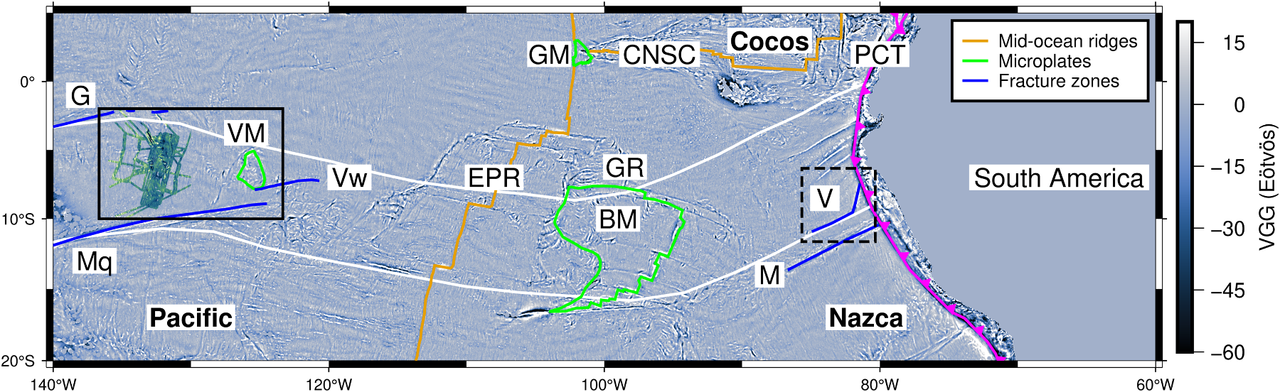
Satellite gravity map of the southeastern Pacific Ocean showing spreading ridges, fracture zones and the Viru Microplate study area.

The Viru Microplate study uses high-resolution satellite gravity data together with new shipboard bathymetry to reveal a previously unknown episode of chaotic seafloor spreading between 44 and 28 million years ago at the Pacific-Farallon plate boundary. This episode produced a newly identified microplate, named the Viru Microplate, along with ridge jumps and propagating spreading ridges. … Read more…

DeepMIP-Eocene-p2: Experimental design for Phase 2 of the early Eocene component of the CMIP7/PMIP7 Deep-time Model Intercomparison Project (DeepMIP-Eocene)

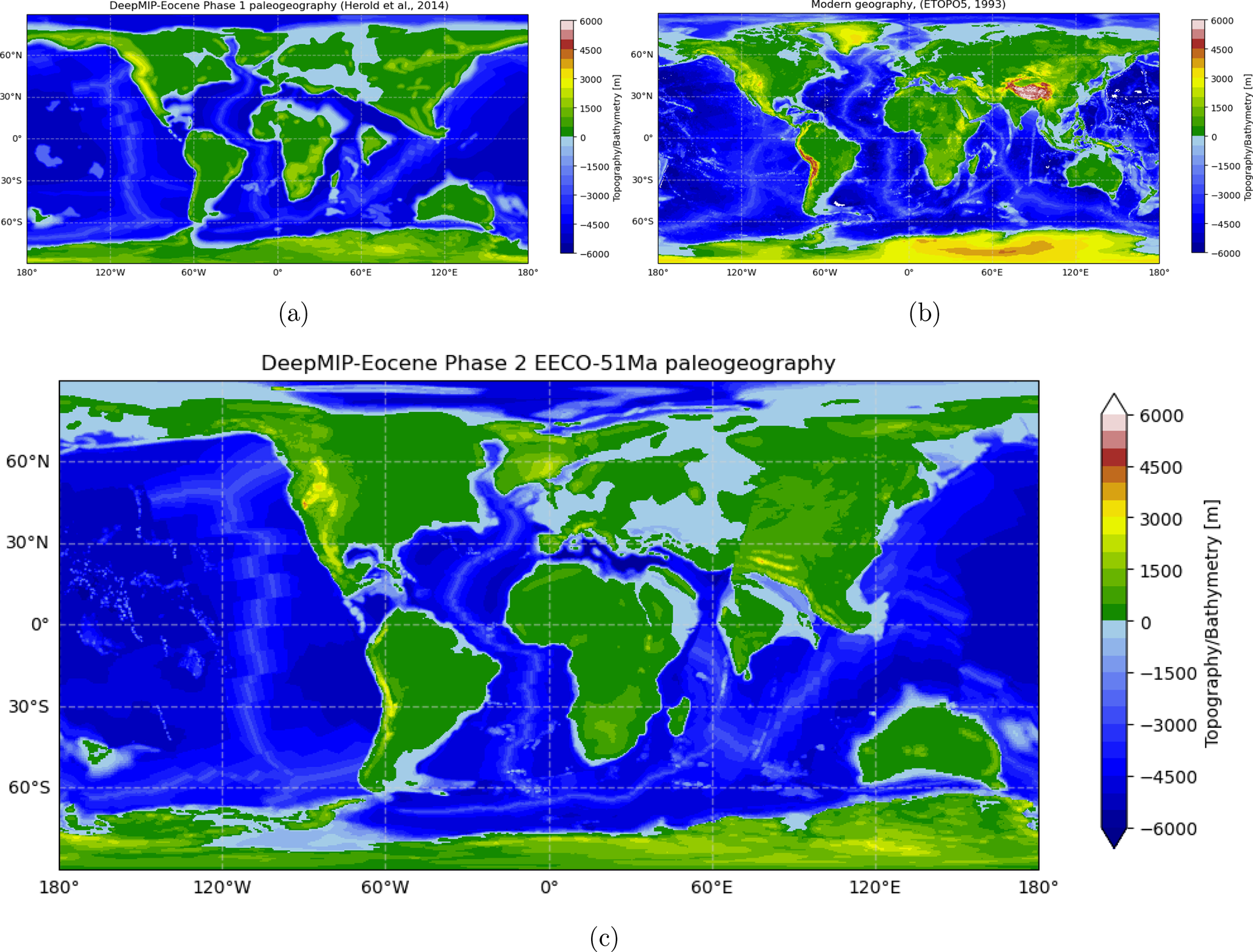
Maps comparing the Phase 1 (55 Ma), modern, and new Phase 2 (51 Ma) paleogeography reconstructions used in the DeepMIP-Eocene model experiments.

This paper outlines the experimental design for Phase 2 of DeepMIP-Eocene, a project that coordinates climate model simulations of the early Eocene, a period around 56–41 million years ago when global temperatures were far higher than today and carbon dioxide levels were much greater. The design updates the paleogeography, vegetation and carbon dioxide inputs used … Read more…

Why Does the Broken Hill Deposit Sit in Resistive Crust? Magnetotelluric Evidence for Metamorphic Decoupling of a World‐Class Mineral System

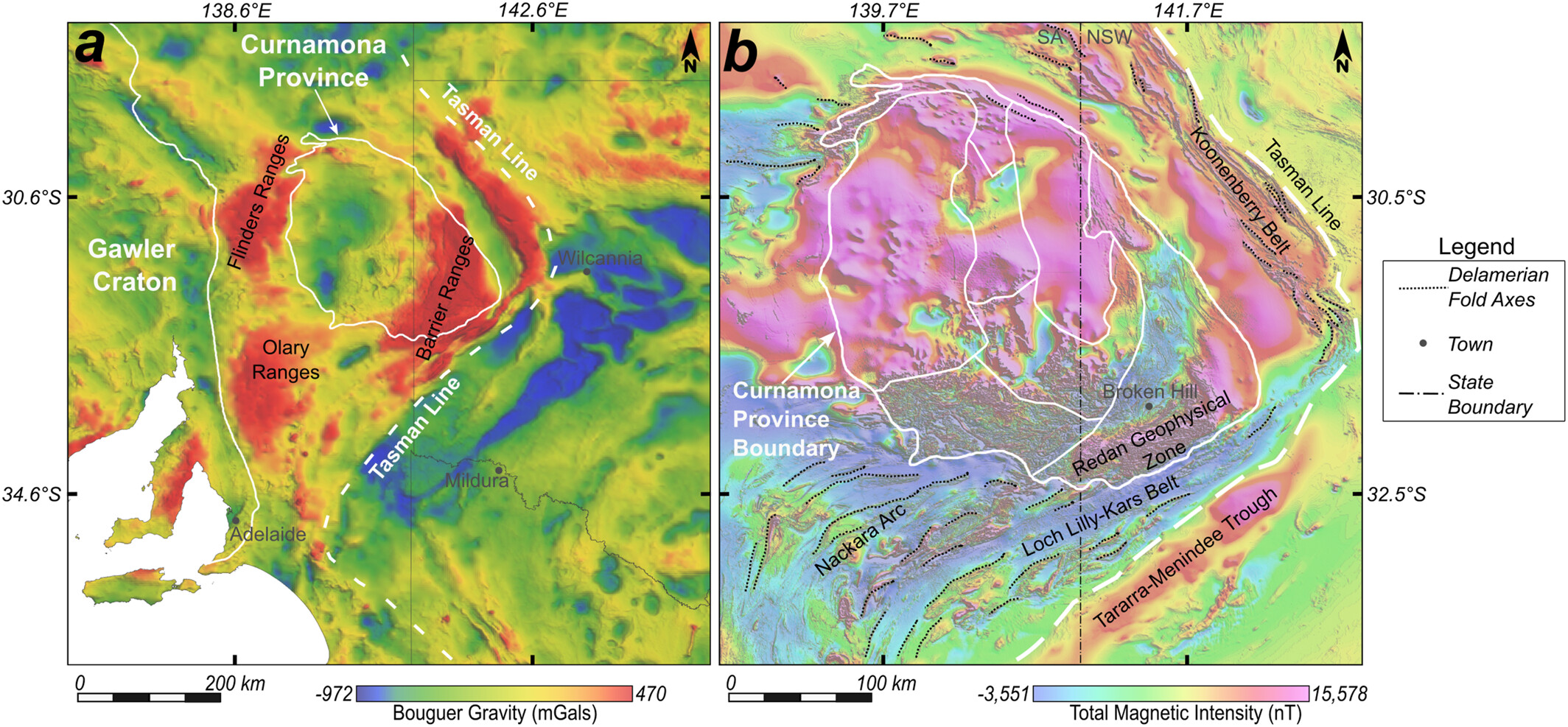
Regional gravity and magnetic anomaly maps showing tectonic boundaries and the location of the Broken Hill deposit, NSW, Australia.

Researchers used magnetotelluric surveys to image the electrical structure of the crust around the world-class Broken Hill Pb-Zn-Ag deposit in NSW, Australia. They found that the upper crust here is mostly resistive, with only small, isolated conductive zones linked to the ore body and its host rocks, which do not connect down to a deeper … Read more…

Tectonic and climatic implications of the Aleutian Arc initiation ≥56 million years ago

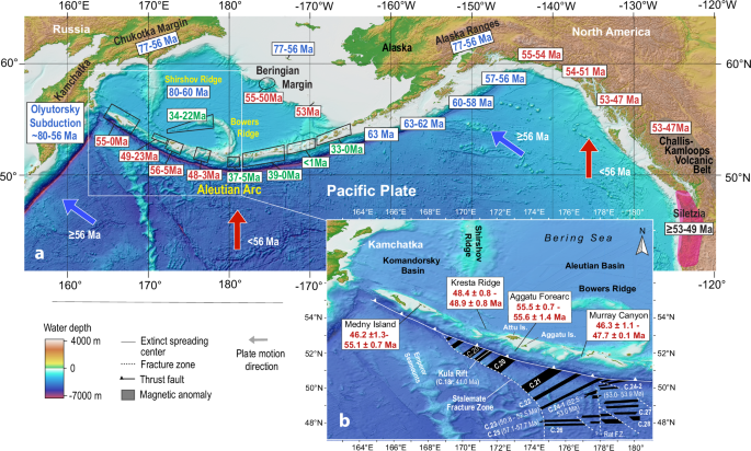
Figure 1 from Hoernle et al. (2026)

Researchers analysed the age and chemistry of lavas from the base of the western Aleutian volcanic arc, sampled across roughly 700 kilometres, to work out when subduction began there. The results show that Aleutian subduction started at least 56 million years ago, with early lavas resembling those formed during the onset of subduction in the … Read more…

How subduction evolution drives sediment-hosted mineralisation along craton edges

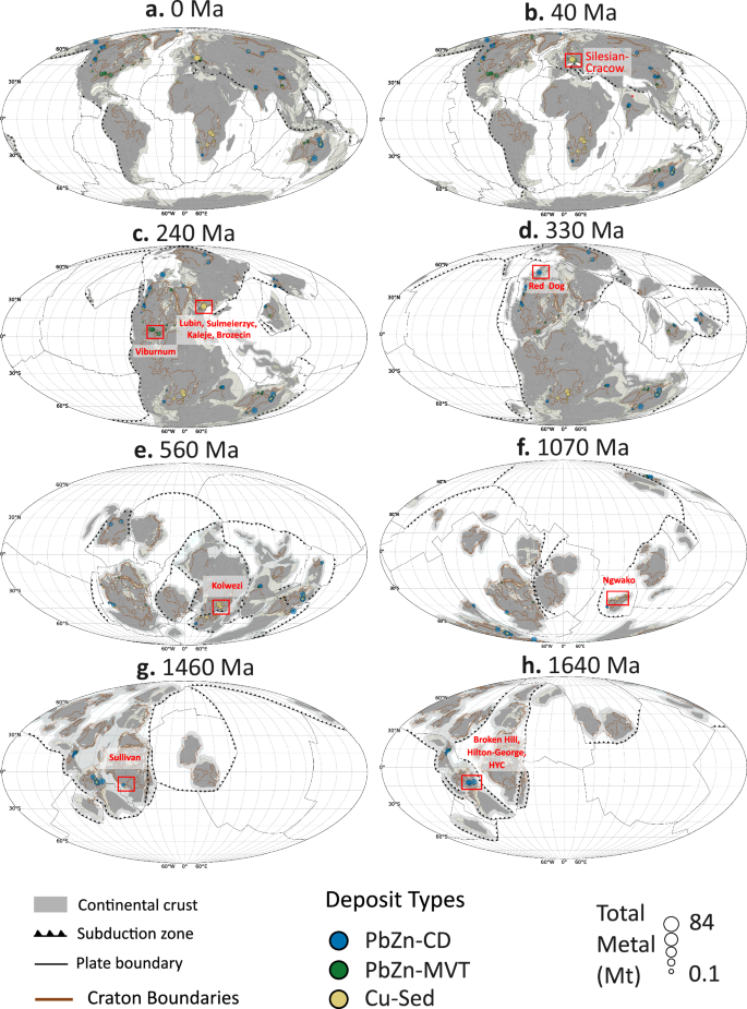
Figure 1 from Shirmard et al. (2026)

This study explores why sediment-hosted mineral deposits tend to form near the edges of ancient continental cores, or cratons. By combining a 1.8-billion-year plate motion model with seismic imaging of craton edges, geodynamic modelling and a global mineral deposit database, the authors show that mineralised craton edges typically formed 800-1800 km from active subduction zones, … Read more…

Influence of secular cooling on core-mantle boundary heat flux and mantle plume temperature over 1.8 billion years

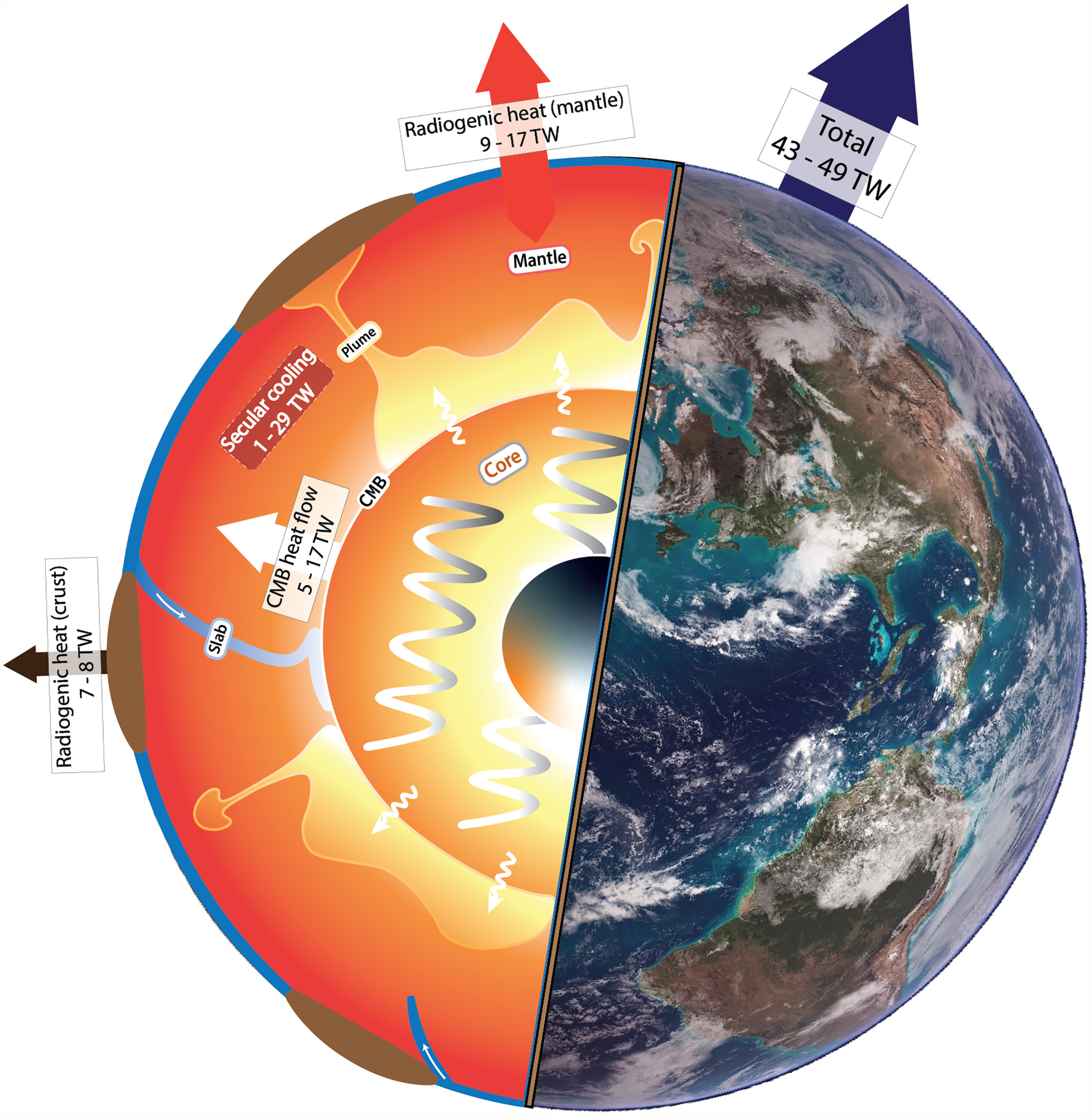
Figure 1 from Zhang et al. (2026)

Researchers modelled global mantle flow over the past 1.8 billion years, incorporating the gradual cooling of Earth’s core and the decay of radiogenic heat sources through time. They found that this long-term cooling reduces both the heat flowing out of the core and the temperature of mantle plumes, at rates consistent with independent geological evidence. … Read more…

Parallel volcanic chains generated by plume-slab interaction

Figure from Mather et al. (2026)

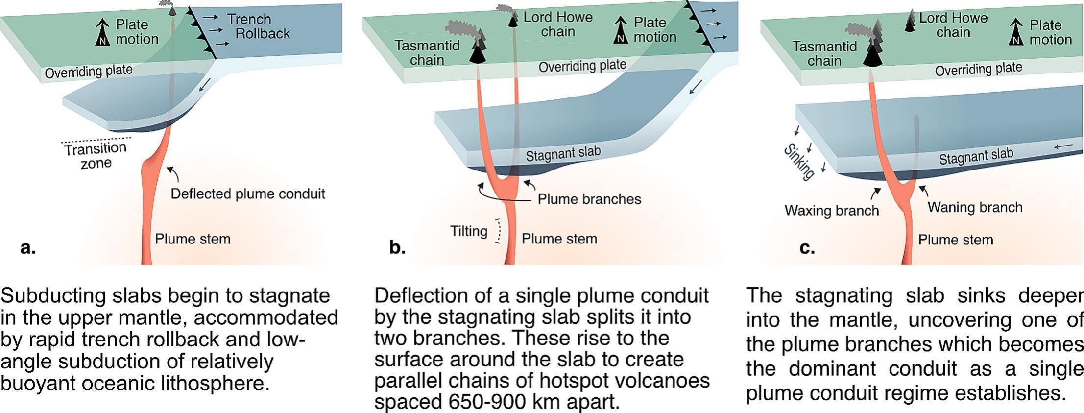
Using a 3D numerical model of mantle convection, the authors show how a single deep mantle plume can be split into two long-lived branches by a stagnating slab in the upper mantle, producing parallel volcanic chains. This explains why the Lord Howe and Tasmantid seamount chains in the SW Pacific have stayed 650–900 km apart … Read more…

Enhancing reproducibility in hybrid Earth system models

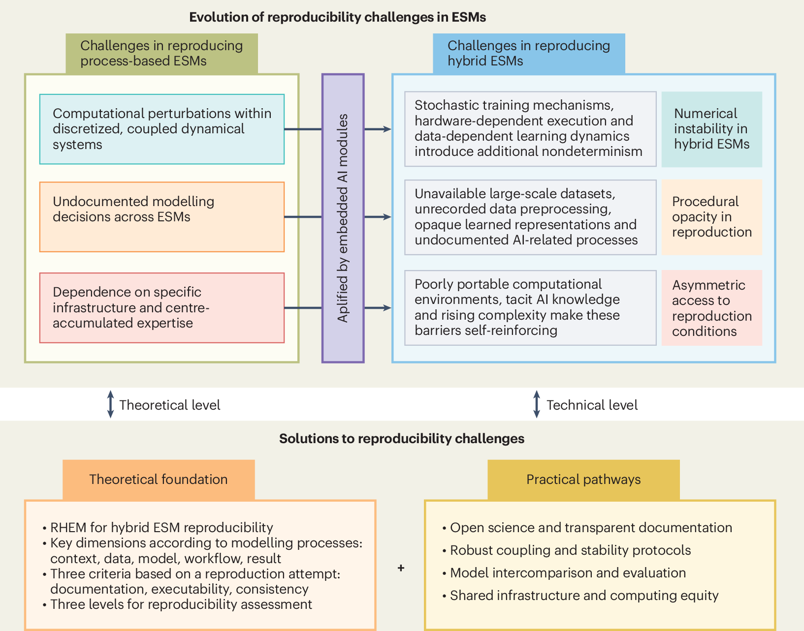
Diagram showing how reproducibility challenges in Earth system models have evolved from process-based frameworks to AI-integrated hybrid systems.

This Perspective argues that as artificial intelligence is increasingly built into Earth system models, reproducibility needs to be rethought to match how these hybrid models actually work. The authors highlight risks such as numerical instability, opaque procedures and unequal access to computing power, which can undermine trust and traceability in climate research. They propose a … Read more…

OK computer: AI reaches human-level accuracy in fission track counting in apatite and mica

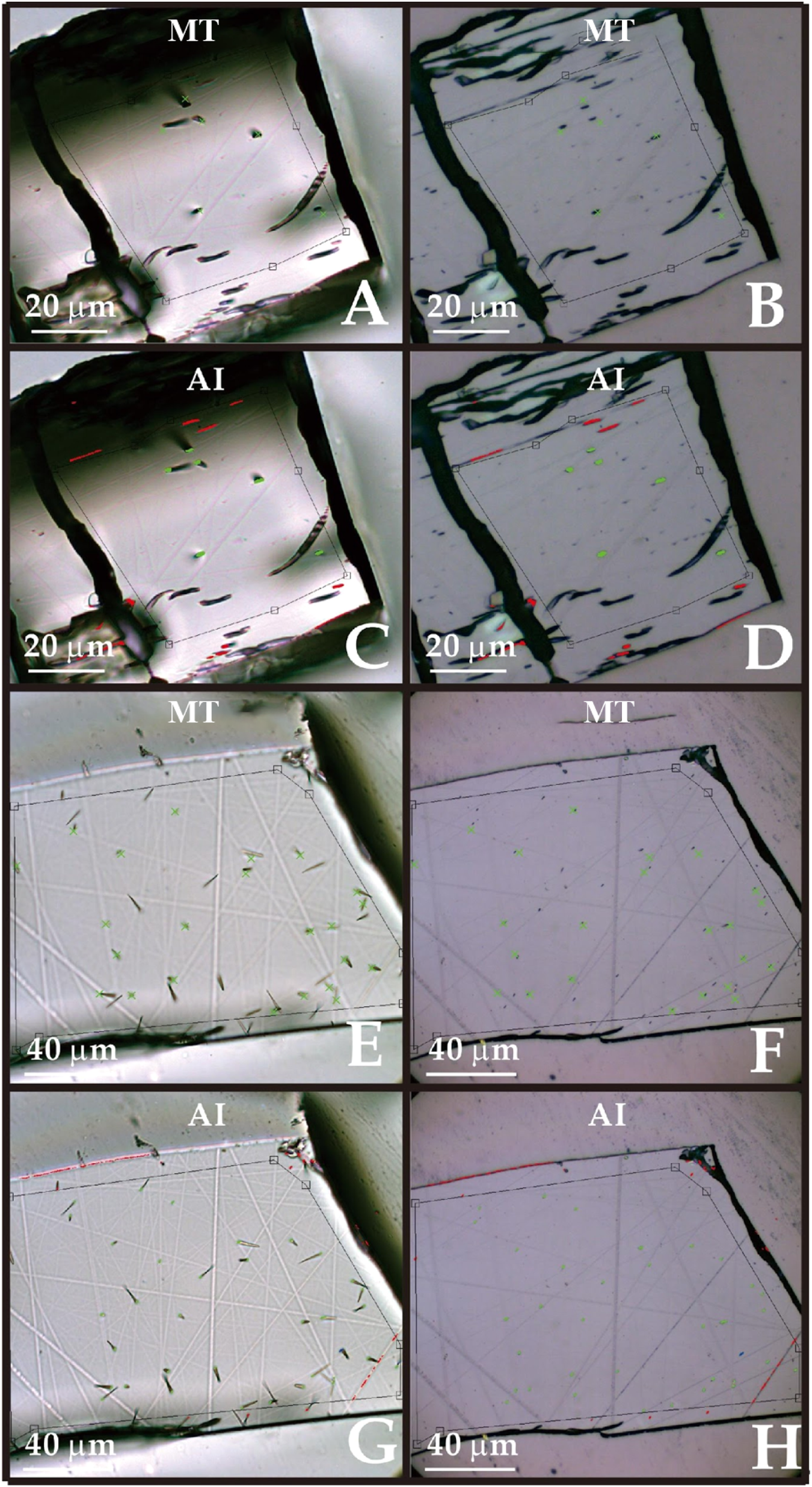
Microscope images comparing human- and AI-identified fission tracks in two apatite grains with differing counting accuracy.

Researchers compared fission track counts made by a trained AI system (HALtracks 2D) with those of an expert human analyst using identical microscope images of apatite and mica samples. The AI matched human counts closely on clean, simple grains and performed comparably to the average expert even on more complex samples, though both struggled with … Read more…

Coral reef trajectories: Altered disturbance regimes correspond with divergence toward ‘flattened’ and ‘algal-dominated’ reef states

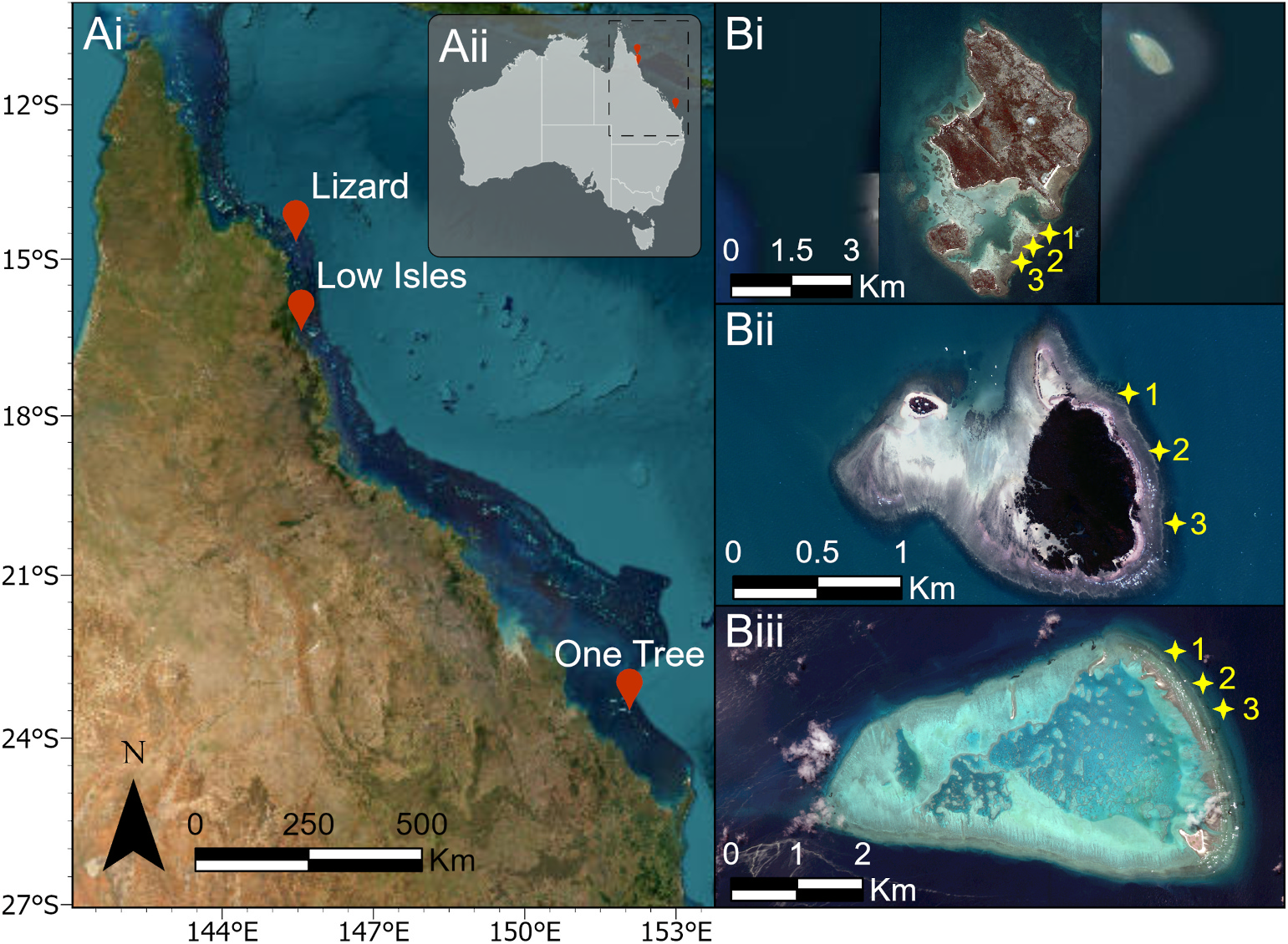
Map of Great Barrier Reef study locations with satellite images of Lizard, Low Isles and One Tree Reefs showing survey sites.

Coral reefs need enough living coral cover to support habitats, build carbonate structures and buffer waves, but it has been unclear exactly when reefs shift between healthy and degraded states, especially since different reefs have different baseline coral cover. This study tracked benthic cover from 1995 to 2022 at three Great Barrier Reef sites, indexing … Read more…

DEEP-SEAM: an explainable semi-supervised deep learning framework for mineral prospectivity mapping

Abstract. The global transition to clean energy is sharply increasing demand for rare earth elements (REEs), yet discovery rates are declining, especially in areas concealed by younger cover. Deep learning (DL) offers new opportunities for mineral prospectivity mapping (MPM), but its application is challenged by sparse labelled mineral occurrences, strong class imbalance, and limited model … Read more…

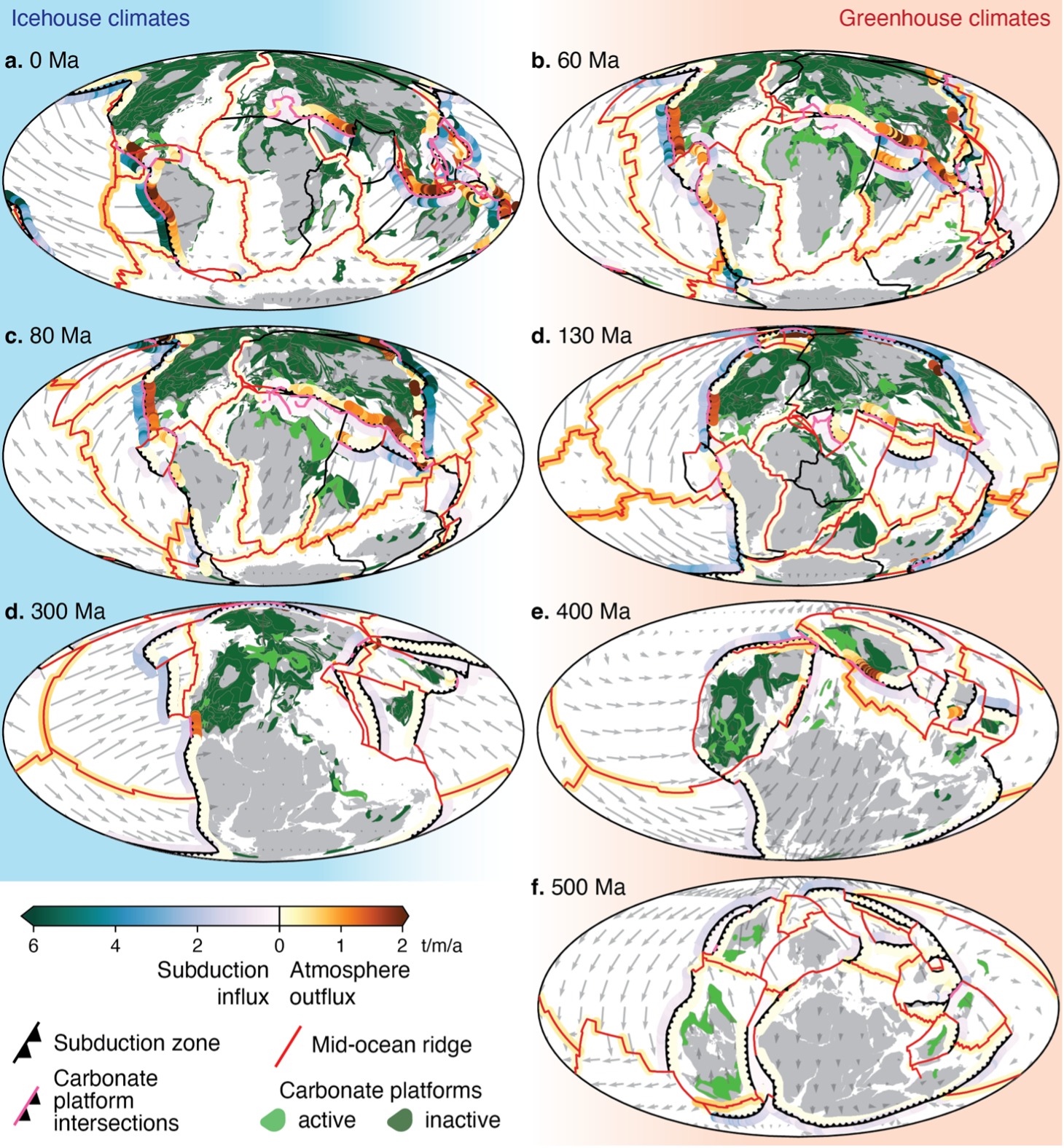
Carbon emissions along divergent plate boundaries modulate icehouse-greenhouse climates

The exchange of carbon between oceanic plates, the deep Earth, and the atmosphere plays a significant role in modulating global climate1,2. Icehouse-greenhouse climate fluctuations have been attributed to changes in palaeogeography and solid Earth degassing3, particularly along continental arcs2,4,5, to arc weathering5 and to the sequestration of carbon into oceanic carbonate-rich sediments6. However, the proportions … Read more…

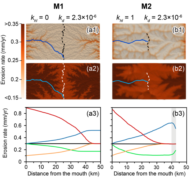
Rainfall and tectonic forcing lead to contrasting headwater slope evolutions

Landscapes evolve through the coupled effects of tectonics and surface processes. Previous studies have shown that uplift rate changes generate upstream-migrating erosion waves, altering downstream slopes while upstream slopes remain constant until the wave arrives. However, the distinctive differences between landscape responses to uplift versus climatic changes, particularly rainfall rate changes, remain incompletely described. This … Read more…

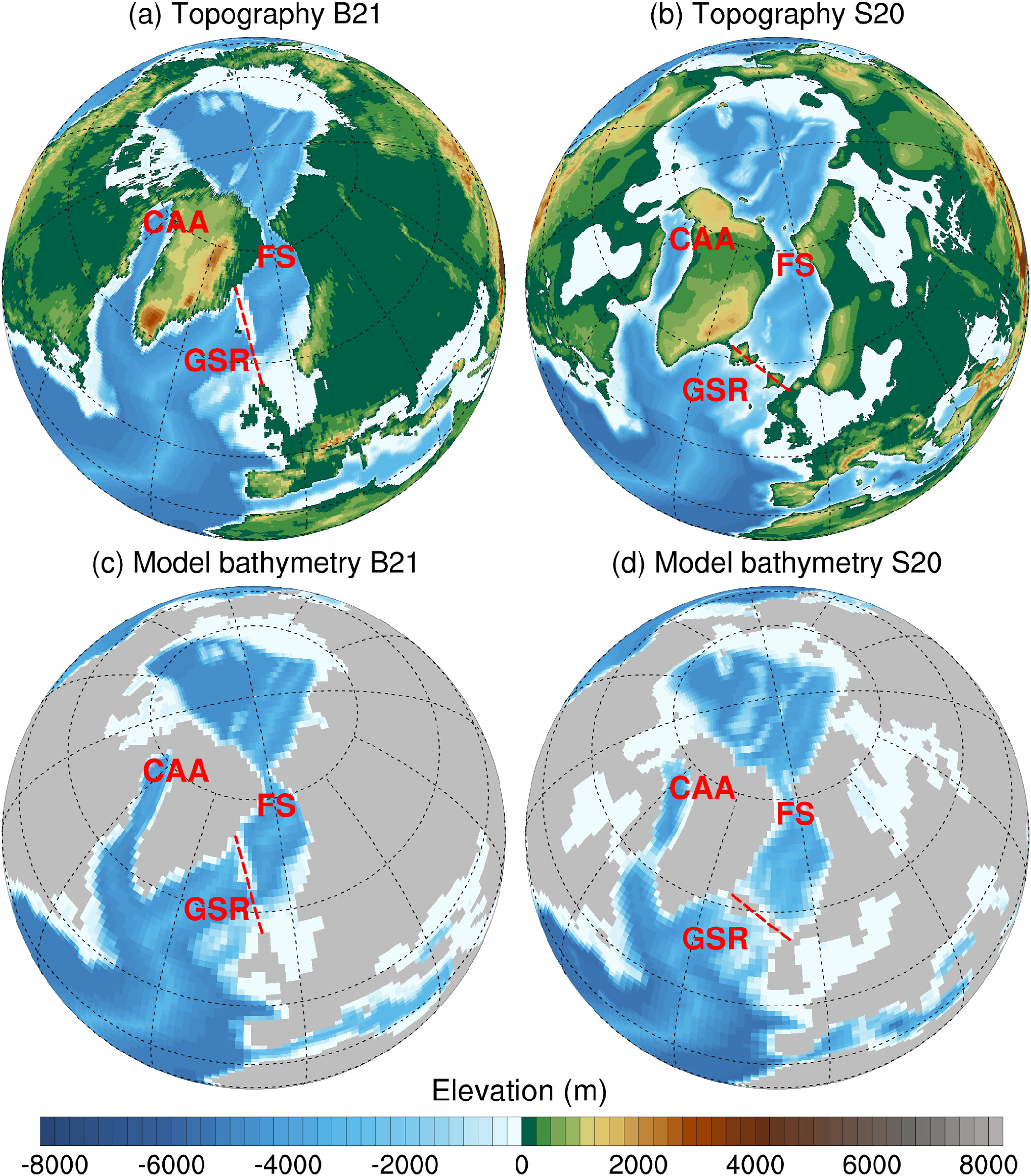
Pacific and Atlantic Modes of Overturning in the Miocene Climatic Optimum

During the Cenozoic Era, the ocean’s meridional overturning circulation (MOC) has alternated between North Pacific and North Atlantic sinking modes. The Miocene Climatic Optimum (17.0–14.7 Ma) is a key interval for reconstructing this history because there is partial and inconclusive evidence for both MOC modes during this period. Here, we use the GFDL CM2.1 coupled climate … Read more…

Thickness of an extensional plate-boundary shear zone in the mantle: Implications for tectonic controls on strain localization and transient strain rates

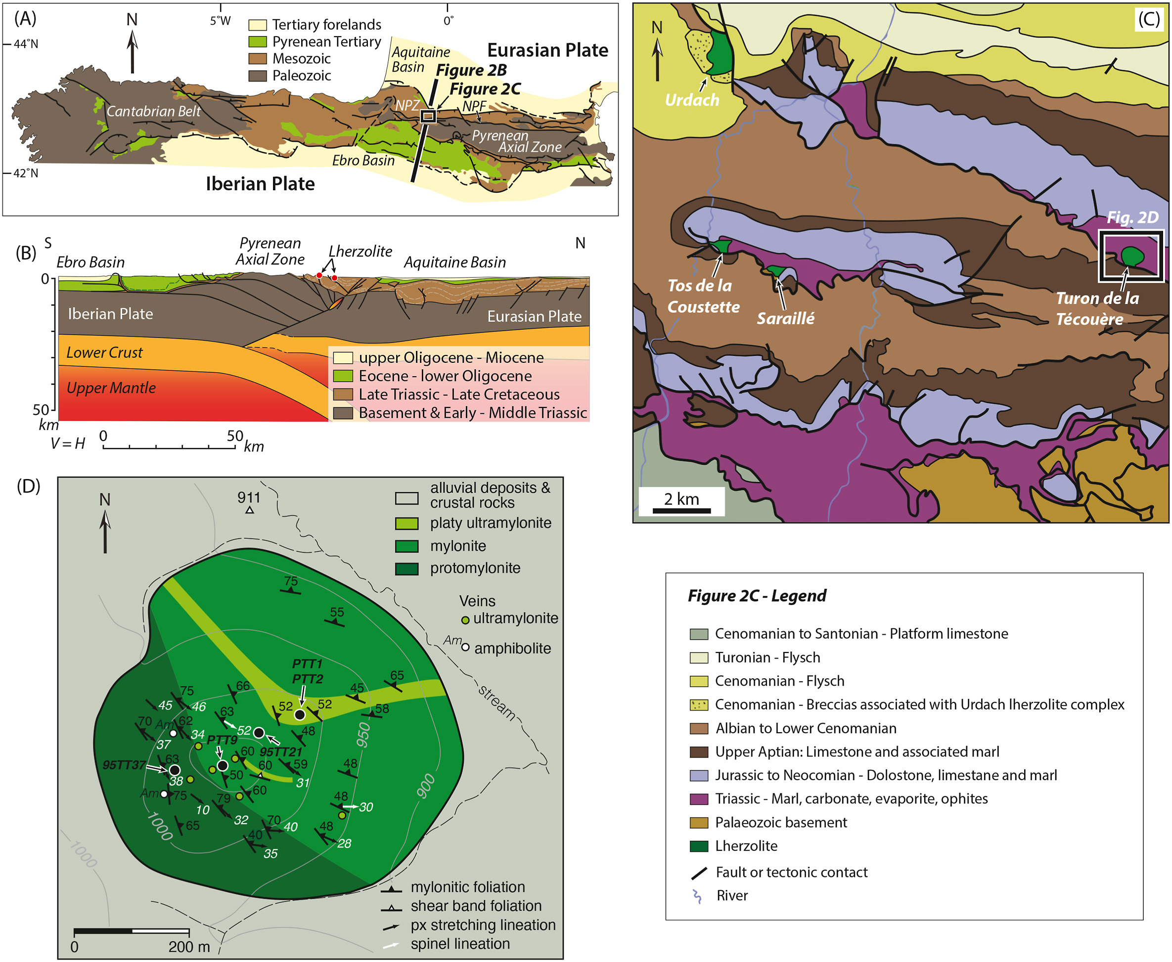
This study shows that constant displacement rate conditions – imposed by plate tectonics – is the best approach to consider the evolution of extensional plate-boundary shear zones, as stresses vary during deformation. The Turon de Técouère massif of the French Pyrenees preserves a Cretaceous, magma-poor hyperextended plate margin within the lithospheric mantle. The massif exposes an extensional … Read more…

Strain controls the electrical conductivity distribution in the lithosphere

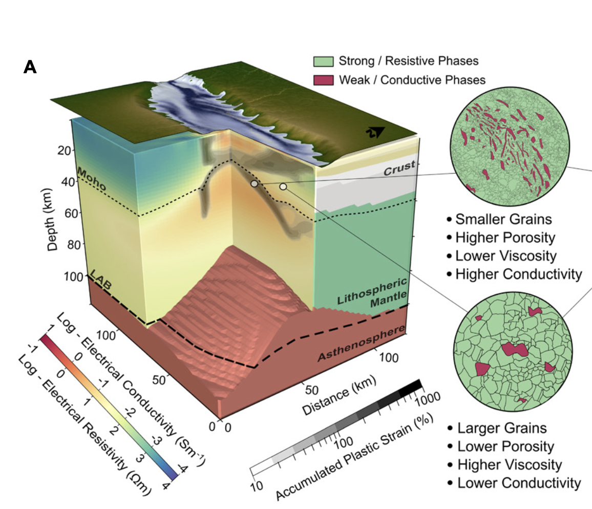
Magnetotellurics (MT) utilize measurements of electromagnetic fields at Earth’s surface to image the electrical conductivity distribution at depths from a few meters to ∼200 km. MT is especially powerful for mapping mineralized fluid pathways, as it is sensitive to inter- connected minor conductive phases such as fluids, melts, or sulfides. However, conductivity anomalies documented by … Read more…

Predicting the preservation of buried ore deposits using deep-­ time landscape evolution modeling


    Porphyry copper discoveries are declining despite rising demand to meet net-zero targets, highlighting the need for innovative exploration strategies. While many advances have focused on ore formation at depth, a major challenge remains in understanding how erosion and uplift over millions of years affect deposit preservation. These post-mineralisation processes determine whether porphyry systems … Read more…

Mid-Proterozoic expansion of passive margins and reduction in volcanic outgassing supported marine oxygenation and eukaryogenesis

The mid-Proterozoic interval between 1800 and 800 Ma, commonly referred to as the “Boring Billion”, was marked by the emergence of eukaryotic cells from prokaryotic ancestors, a key step in the evolution of life. This period encompassed the assembly and dispersal of two consecutive supercontinents, Nuna and Rodinia, as well as the development of extensive … Read more…

Indian Ocean carbonate compensation depth since the Late Oligocene

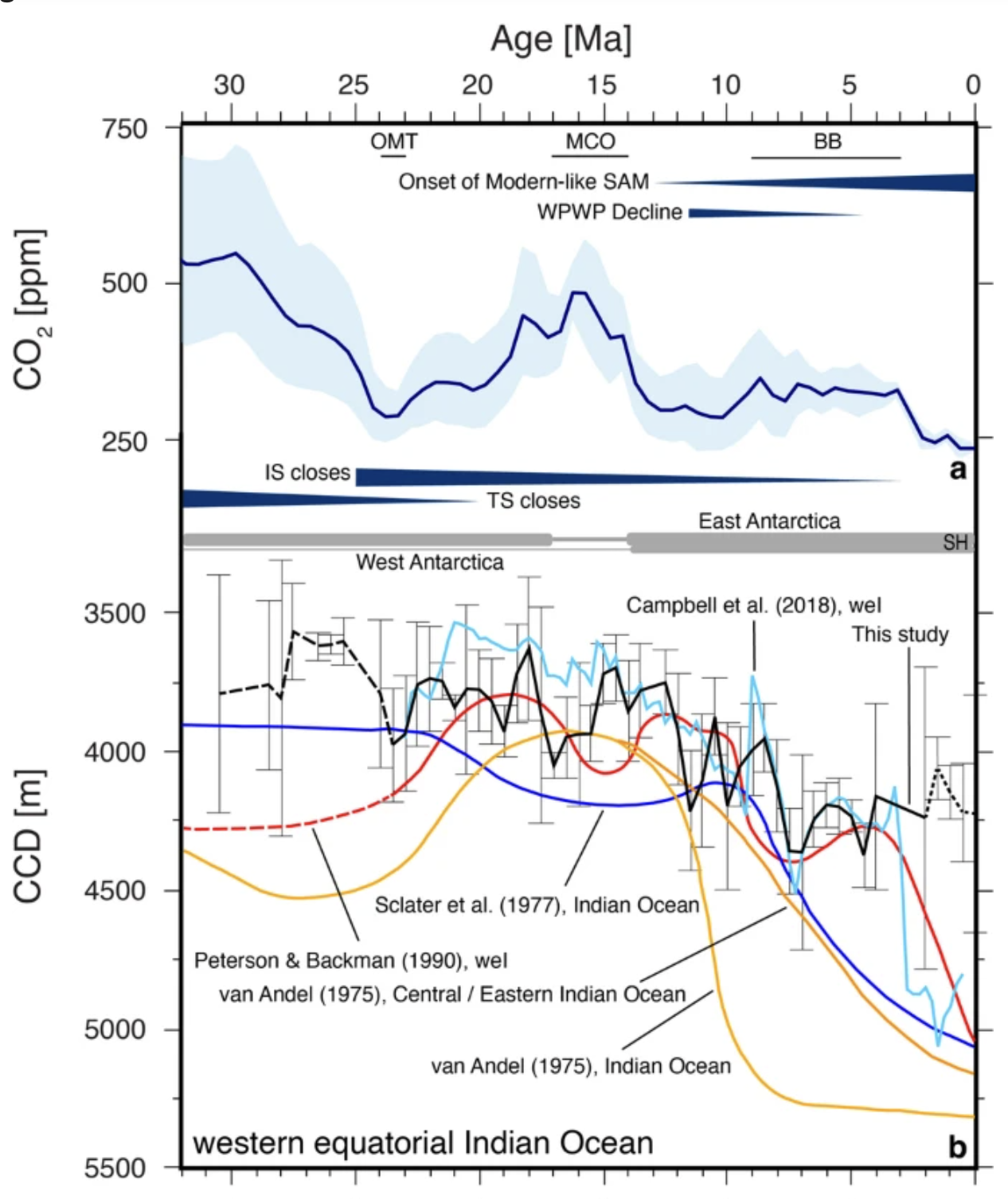
The carbonate compensation depth (CCD), defined as the depth in the ocean where the supply rate of pelagic carbonate is balanced by its dissolution, provides an important parameter for estimating the amount of calcium carbonate-bound carbon that is stored in deep-sea sediments. The CCD is reasonably well-constrained across the Atlantic and Pacific oceans; however, our … Read more…

SAnTex: A Python-based Library for Seismic Anisotropy Calculation

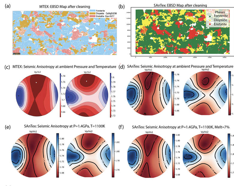
Seismic anisotropy, the directional dependency of seismic wave velocities, is important for mapping the Earth’s structure and understanding geodynamic processes. Seismic anisotropy primarily stems from the development of mineral crystallographic preferred orientation (i.e. texture) during the plastic deformation of rocks. In-depth analysis of data from texture characterization techniques like Electron Backscatter Diffraction (EBSD) enables the … Read more…

Polar wander leads to large differences in past climate reconstructions

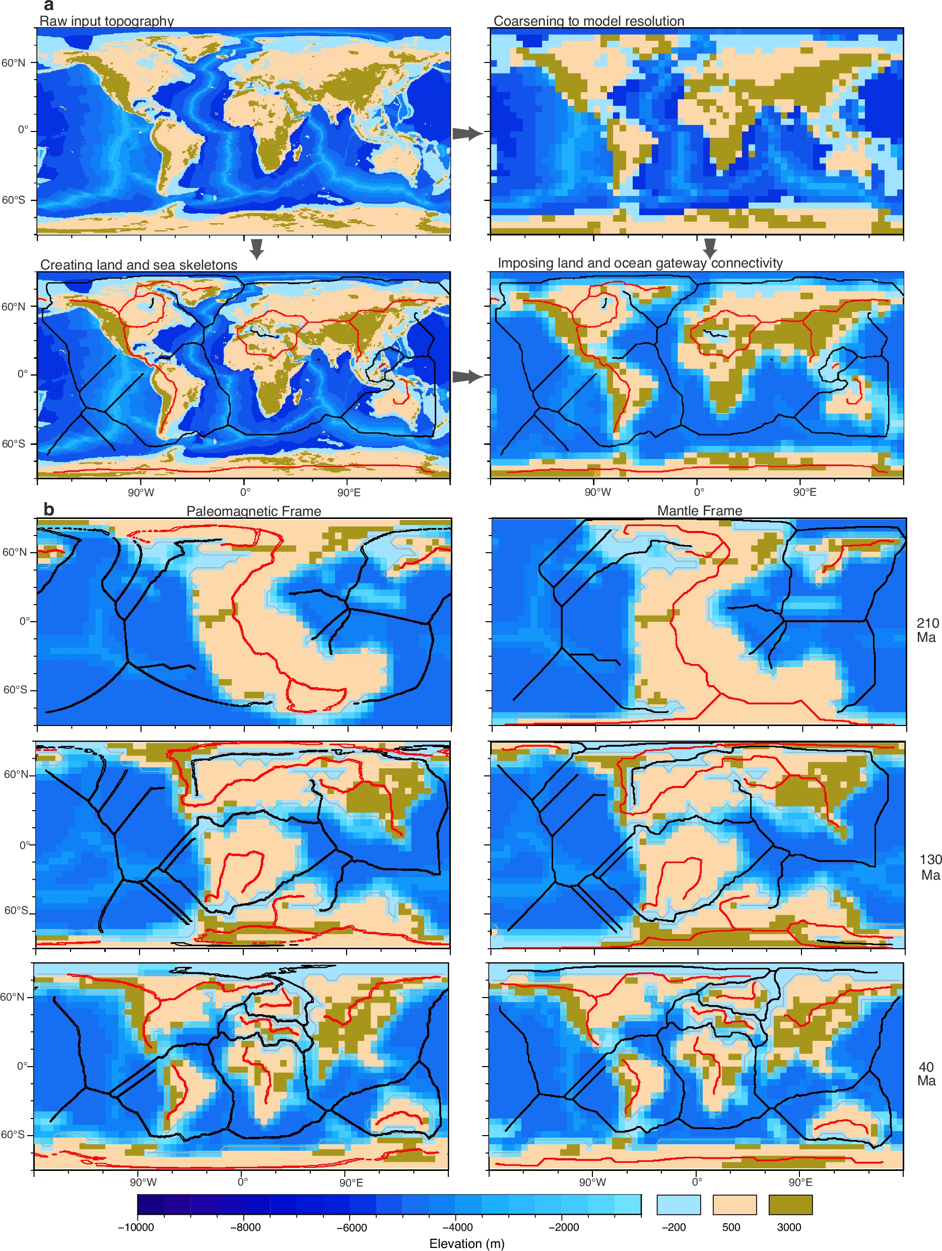
The position of continents and oceans in geological time dictates the biogeographic dispersal of life, influences the preservation of mineral resources, and informs our understanding of Earth’s climate trajectory. Reconstructing past crustal locations requires a plate tectonic model that differs depending on whether the model uses a mantle reference frame, or a paleomagnetic reference frame, … Read more…

A High-resolution 3-D Shear Velocity Model for Cameroon using Ambient Noise Tomography: Constraints from the CPSO algorithm

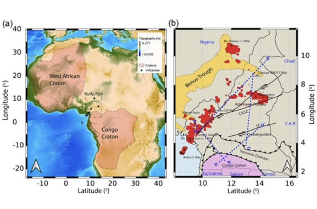
The Cameroon Volcanic Line (CVL) and other tectonic features in Cameroon remain enigmatic, prompting ongoing debates about their detailed crustal structure, composition and geodynamic evolution. To shed light on the structural complexities and the underlying crustal processes, we leverage the two-step ambient noise tomography method to obtain the 3-D shear wave velocity (Vs) and the P-to-S wave … Read more…

Heterogeneous Earth’s mantle drilled at an embryonic ocean

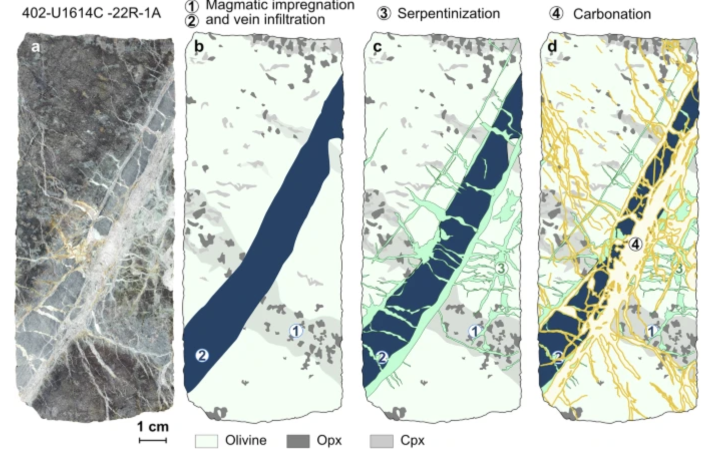
Mantle processes control plate tectonics and exert an influence on biogeo- chemical cycles. However, the proportion of mantle sampled in-situ is minimal, as it is buried beneath igneous crust and sediments. Here we report the lithological characteristics of two mantle sections from an embryonic ocean drilled by the International Ocean Discovery Program (IODP) in the … Read more…

Thermo‐mechanical rift evolution of large igneous province crust

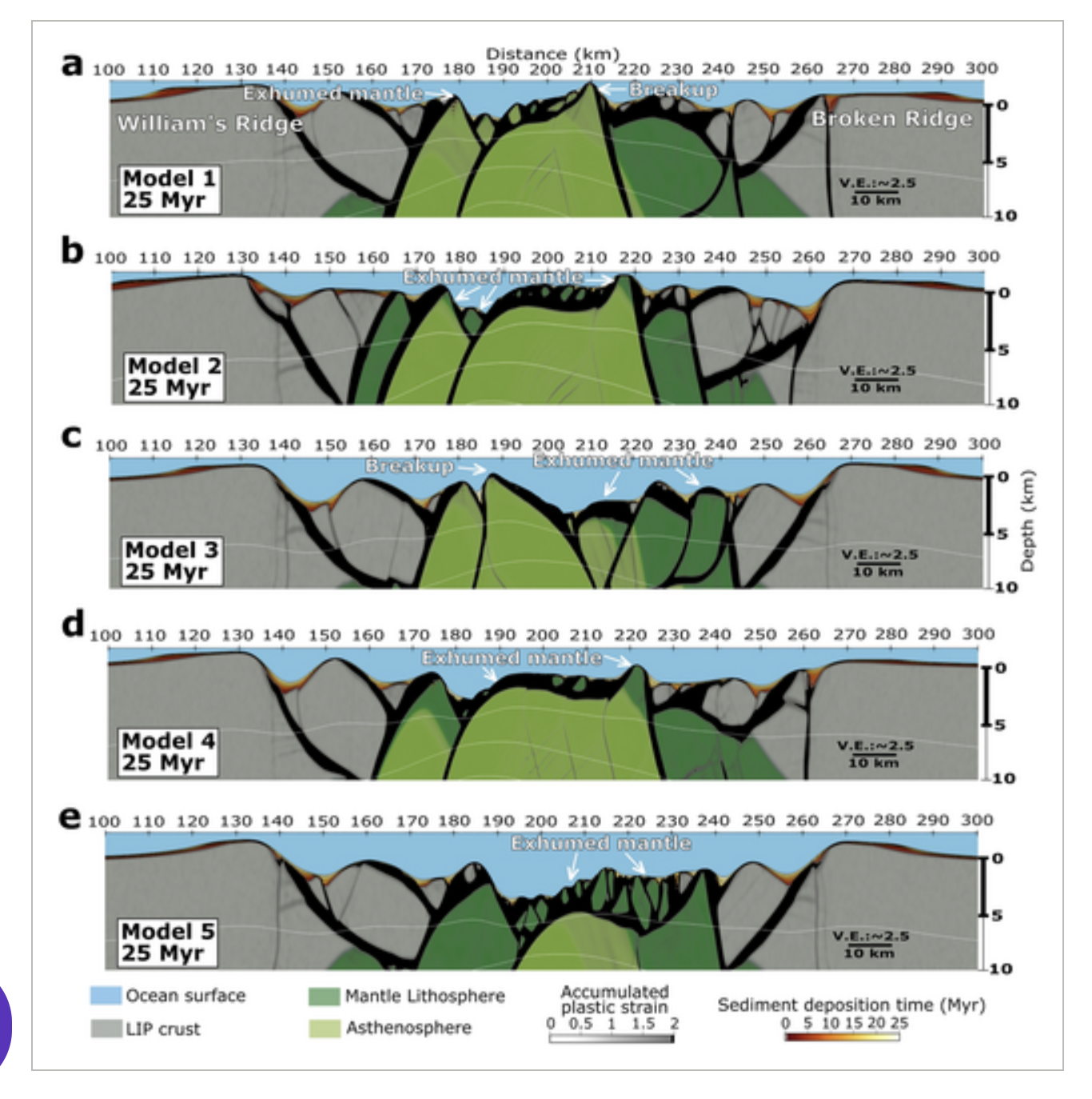
Numerical models, coupled with observational data, have proven crucial for addressing fundamental questions regarding extensional processes from continental rift to mid-ocean ridge (MOR). However, extensional processes at Large Igneous Provinces (LIP), a distinct type of lithosphere, have not been examined, leaving a thorough comprehension of rift mechanics unresolved. Here, we model the thermo-mechanical evolution for … Read more…

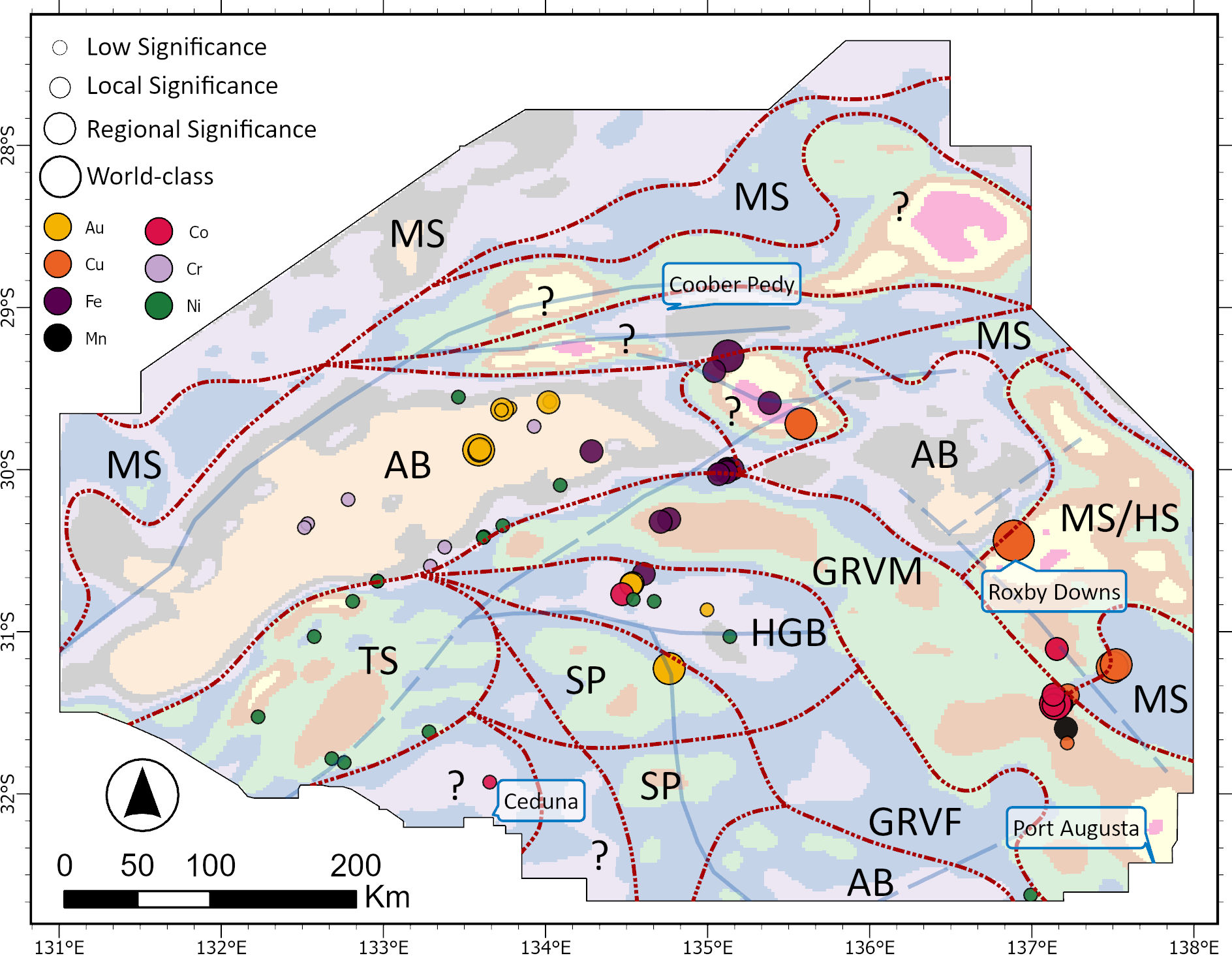
Automated Detection of Mineralization-Related Craton Structures Using Geophysical Data and Unsupervised Machine Learning

Internal structures and discontinuities within cratons are economically significant due to their history of tectonic reactivation from varying intraplate stress fields, which open pathways for fluid flow and facilitate mineral deposition. However, the complex overprinting tectonic processes that make cratons prospective can also lead to uncertainty regarding their internal geometries. To address this, we take … Read more…