GPlates 2.4 software and data sets

GPlates Title Logo


GPlates is a free desktop software for the interactive visualisation of plate-tectonics. The compilation and documentation of GPlates 2.4 data was primarily funded by AuScope National Collaborative Research Infrastructure (NCRIS).

GPlates is developed by the EarthByte Group (part of AuScope NCRIS) at the University of Sydney and the Division of Geological and Planetary Sciences (GPS) at California Institute of Technology (CalTech). … Read more…

Share

GPlates 2.3 software and data sets

GPlates Title Logo


GPlates is a free desktop software for the interactive visualisation of plate-tectonics. The compilation and documentation of GPlates 2.3 data was primarily funded by AuScope National Collaborative Research Infrastructure (NCRIS).

GPlates is developed by the EarthByte Group (part of AuScope NCRIS) at the University of Sydney and the Division of Geological and Planetary Sciences (GPS) at California Institute of Technology (CalTech). … Read more…

Share

The interplay of dynamic topography and eustasy on continental flooding in the late Paleozoic

Abstract: Global sea level change can be inferred from sequence stratigraphic and continental flooding data. These methods reconstruct sea level from peri-cratonic and cratonic basins that are assumed to be tectonically stable and sometimes called reference districts, and from spatio-temporal correlations across basins. However, it has been understood that long-wavelength (typically hundreds of km) and low-amplitude … Read more…

GPlates 2.2 software and data sets

GPlates Title Logo

GPlates 1.5 PromoGPlates is a free desktop software for the interactive visualisation of plate-tectonics. The compilation and documentation of GPlates 2.2 data was primarily funded by AuScope National Collaborative Research Infrastructure (NCRIS).

GPlates is developed by an international team of scientists and professional software developers at the EarthByte Project (part of AuScope) at the University of Sydney, the Division of Geological and Planetary Sciences (GPS) at CalTech, the Geodynamics team at the Geological Survey of Norway (NGU) and the Centre for Earth Evolution and Dynamics (CEED) at the University of Oslo. … Read more…

Share

The interplay of dynamic topography and eustasy on continental flooding in the late Paleozoic

Abstract: Global sea level change can be inferred from sequence stratigraphic and continental flooding data. These methods reconstruct sea level from peri-cratonic and cratonic basins that are assumed to be tectonically stable and sometimes called reference districts, and from spatio-temporal correlations across basins. However, it has been understood that long-wavelength (typically hundreds of km) and … Read more…

GPlates 2.1 software and data sets

GPlates Title Logo

GPlates 1.5 PromoGPlates is a free desktop software for the interactive visualisation of plate-tectonics. The compilation and documentation of GPlates 2.1 data was primarily funded by AuScope National Collaborative Research Infrastructure (NCRIS).

GPlates is developed by an international team of scientists and professional software developers at the EarthByte Project (part of AuScope) at the University of Sydney, the Division of Geological and Planetary Sciences (GPS) at CalTech, the Geodynamics team at the Geological Survey of Norway (NGU) and the Centre for Earth Evolution and Dynamics (CEED) at the University of Oslo. … Read more…

Share

Global Dynamic Topography Models

Cao et al., 2018

Cao, X., Flament, N, Müller, R.D. and Li, S., 2018, The dynamic topography of eastern China since the latest Jurassic Period , Tectonics.

Müller et al., 2017

Müller R.D., Hassan, R., Gurnis, M., Flament, N., and Williams, S.E., 2017, Dynamic topography of passive continental margins and their hinterlands since the Cretaceous, Gondwana Research, in press, accepted 21 March 2017.

Barnett-Moore et al., 2017

Barnett-Moore, N., R. Hassan, R. D. Müller, S. E. Williams, and N. Flament (2017), Dynamic topography and eustasy controlled the paleogeographic evolution of northern Africa since the mid-Cretaceous , Tectonics, 36, 929–944, doi:10.1002/2016TC004280.

 Rubey et al., 2017

Rubey, M., Brune, S., Heine, C., Davies, D. R., Williams, S. E., and Müller R. D.: Global patterns of Earth’s dynamic topography since the Jurassic, Solid Earth Discuss., doi:10.5194/se-2017-26, in press, 2017.

Müller et al., 2016

Müller, R. D., Flament, N., Matthews, K. J., Williams, S. E., & Gurnis, M. (2016). Formation of Australian continental margin highlands driven by plate-mantle interaction.. Earth and Planetary Science Letters, 441, 60-70. http://dx.doi.org/10.1016/j.epsl.2016.02.025

Zahirovic et al., 2016a

Zahirovic, S., Matthews, K. J., Flament, N., Müller, R. D., Hill, K. C., Seton, M., & Gurnis, M. (2016a). Tectonic evolution and deep mantle structure of the eastern Tethys since the latest Jurassic. Earth-Science Reviews, 162, 293-337.

Zahirovic et al.,2016b

Zahirovic, S., Flament, N., Müller, R. D, Seton, M., & Gurnis, M. (2016b). Large fluctuations of shallow seas in low-lying Southeast Asia driven by mantle flow. Geochemistry, Geophysics, Geosystems, 17(9), 3589-3607.

Flament et al., 2015

Flament, N., Gurnis, M., Müller R. D., Bower, D. J., & Husson, L. (2015). Influence of subduction history on South American topography. Earth and Planetary Science Letters, 430, 9-18, http://dx.doi.org/10.1016/j.epsl.2015.08.006.

Seton et al., 2015

Seton, M., Flament, N., Whittaker, J., Müller, R. D., Gurnis, M., & Bower, D. J. (2015). Ridge subduction sparked reorganization of the Pacific plate-mantle system 60.50 million years ago. Geophysical Research Letters, 42(6), 1732-1740.

Bower et al., 2015

Bower, D. J., Gurnis, M., & Flament, N. (2015). Assimilating lithosphere and slab history in 4-D Earth models. Physics of the Earth and Planetary Interiors, 238, 8-22.

Flament et al., 2014

Read more…

Share

The deep Earth origin of the Iceland plume and its effects on regional surface uplift and subsidence

Abstract The present-day seismic structure of the mantle under the North Atlantic Ocean indicates that the Iceland hotspot represents the surface expression of a deep mantle plume, which is thought to have erupted in the North Atlantic domain during the Palaeocene. The spatial and temporal evolution of the plume since its eruption is still highly … Read more…

Dynamic topography of passive continental margins and their hinterlands since the Cretaceous

Author List: Dietmar Müller, Rakib Hassan, Michael Garnis, Nicolas Flament, Simon Williams. Citation: Müller, Dietmar & Hassan, Rakib & Gurnis, M & Flament, Nicolas & Williams, Simon. (2018). Dynamic topography of passive continental margins and their hinterlands since the Cretaceous. Gondwana Research. . 10.1016/j.gr.2017.04.028. Abstract: Even though it is well accepted that the Earth’s surface topography has been … Read more…

GPlates 2.0 software and data sets

GPlates 1.5 PromoGPlates is a free desktop software for the interactive visualisation of plate-tectonics. The compilation and documentation of GPlates 2.0 data was primarily funded by AuScope National Collaborative Research Infrastructure (NCRIS).

GPlates is developed by an international team of scientists and professional software developers at the EarthByte Project (part of AuScope) at the University of Sydney, the Division of Geological and Planetary Sciences (GPS) at CalTech, the Geodynamics team at the Geological Survey of Norway (NGU) and the Centre for Earth Evolution and Dynamics (CEED) at the University of Oslo.  … Read more…

Share

Influence of subduction history on South American topography

Case 4 paleotopography 16MaCitation
Flament, N., Gurnis, M., Müller, R. D., Bower, D. J., & Husson, L. (2015). Influence of subduction history on South American topography. Earth and Planetary Science Letters, 430, 9-18. doi: 10.1016/j.epsl.2015.08.006.

Abstract
The Cenozoic evolution of South American topography is marked by episodes of large-scale uplift and subsidence not readily explained by lithospheric deformation. The drying up of the inland Pebas system, the drainage reversal of the Amazon river, the uplift of the Sierras Pampeanas and the uplift of Patagonia have all been linked to the evolution of mantle flow since the Miocene in separate studies. Here we investigate the evolution of long-wavelength South American topography as a function of subduction history in a time-dependent global geodynamic model. This model is shown to be consistent with these inferred changes, as well as with the migration of the Chaco foreland basin depocentre, that we partly attribute to the inboard migration of subduction resulting from Andean mountain building. … Read more…

Share

Topographic asymmetry of the South Atlantic from global models of mantle flow and lithospheric stretching

Flament et al EPSL 2014 - FigureCitation
Flament, N., Gurnis, M., Williams, S., Seton, M., Skogseid, J., Heine, C., & Müller, R. D. (2014). Topographic asymmetry of the South Atlantic from global models of mantle flow and lithospheric stretching. Earth and Planetary Science Letters, 387, 107-119. dx.doi.org/10.1016/j.epsl.2013.11.017.

Abstract
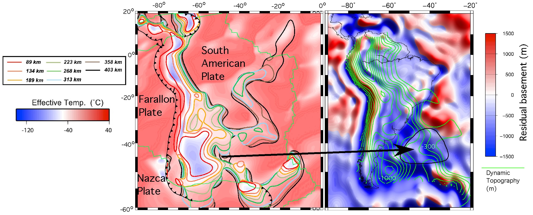
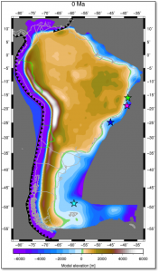
The relief of the South Atlantic is characterized by elevated passive continental margins along southern Africa and eastern Brazil, and by the bathymetric asymmetry of the southern oceanic basin where the western flank is much deeper than the eastern flank. We investigate the origin of these topographic features in the present and over time since the Jurassic with a model of global mantle flow and lithospheric deformation. The model progressively assimilates plate kinematics, plate boundaries and lithospheric age derived from global tectonic reconstructions with deforming plates, and predicts the evolution of mantle temperature, continental crustal thickness, long-wavelength dynamic topography, and isostatic topography. … Read more…

Share

A review of observations and models of dynamic topography

Citation
Flament, N., Gurnis, M., & Müller, R. D. (2013). A review of observations and models of dynamic topography. Lithosphere, 5(2), 189-210. doi: 10.1130/L245.1

Flament-et-al_fig1Summary
The topography of Earth is primarily controlled by lateral differences in the density structure of the crust and lithosphere. In addition to this isostatic topography, flow in the mantle induces deformation of its surface leading to dynamic topography. This transient deformation evolves over tens of millions of years, occurs at long wavelength, and is relatively small (<2 km) in amplitude. Here, we review the observational constraints and modeling approaches used to understand the amplitude, spatial pattern, and time dependence of dynamic topography. … Read more…

Share

The IntraCONtinental basinS (ICONS) atlas

The ICONS atlas is a collection of basin data for over 240 intracontinental sedimentary basins, displaying crustal structure data, computed extension factors and tectonic subsidence grids and derivatives thereof as well as the dynamic topography evolution of a given basin. The atlas was compiled by Christian Heine as part of his PhD project investigating the formation and … Read more…

Dynamic topography and anomalously negative residual depth of the Argentine Basin

Shephard 2012 Argentine Basin-1A substantial portion of Earth’s topography is known to be caused by the viscous coupling of mantle flow to the lithosphere but the relative contributions of shallow asthenospheric flow versus deeper flow remains controversial. The Argentine Basin, located offshore of the Atlantic margin of southern South America, is one of the most anomalously deep ocean regions as it is significantly deeper than its age would suggest. … Read more…

Share

Dynamic subsidence of eastern Australia during the Cretaceous

Dynamic Subsidence of Eastern Australia Matthews et al (2011)During the Early Cretaceous Australia’s eastward passage over sinking subducted slabs induced widespread dynamic subsidence and formation of a large eperiogenic sea in the eastern interior. Despite evidence for convergence between Australia and the paleo-Pacific, the subduction zone location has been poorly constrained. Using coupled plate tectonic-mantle convection models, we test two end-member scenarios, one with subduction directly east of Australia’s reconstructed continental margin, and a second with subduction translated ~1000 km east, implying the existence of a back-arc basin. Our models incorporate a rheological model for the mantle and lithosphere, plate motions since 140 Ma and evolving plate boundaries. While mantle rheology affects the magnitude of surface vertical motions, timing of uplift and subsidence depends on plate boundary geometries and kinematics. … Read more…

Share