Extension velocities along Gondwana's Jurassic-Cenozoic rift systems. Each circle depicts the rift velocity of one passive margin point in terms of circle colour and size. Visit the interactive virtual rift globe here.
... Read more...
See clips below and visit our EarthByte YouTube channel.
When floodwaters recede, where do they go? By Loren Smith University of Sydney researchers have modelled water-storing aquifers that perform a natural balancing act: they absorb water during floods and supply water during drought. Yet human intervention is limiting their function. University of Sydney researchers have identified a groundwater ‘superhighway’ along Australia’s east coast. Stretching from … Read more…
The Basin Genesis Hub (BGH), completed in mid-2021, was an ARC and industry-supported research centre for developing technologies to better understand basin geodynamics and the evolution of sedimentary systems. Most of Australia is covered by sedimentary basins and there are nearly a thousand basins worldwide. Many of the resources that are essential for life and … Read more…
Carbonate accumulation rates (CAR) in the South Atlantic through time, with the average CCD for the South Atlantic shown in black, which the CCD in the Walvis Ridge/Rio Grande Rise area is shown in magenta. Deep-sea carbonate deposition is a complex process that is encapsulated in the carbonate compensation depth (CCD)—a facies boundary separating calcareous … Read more…
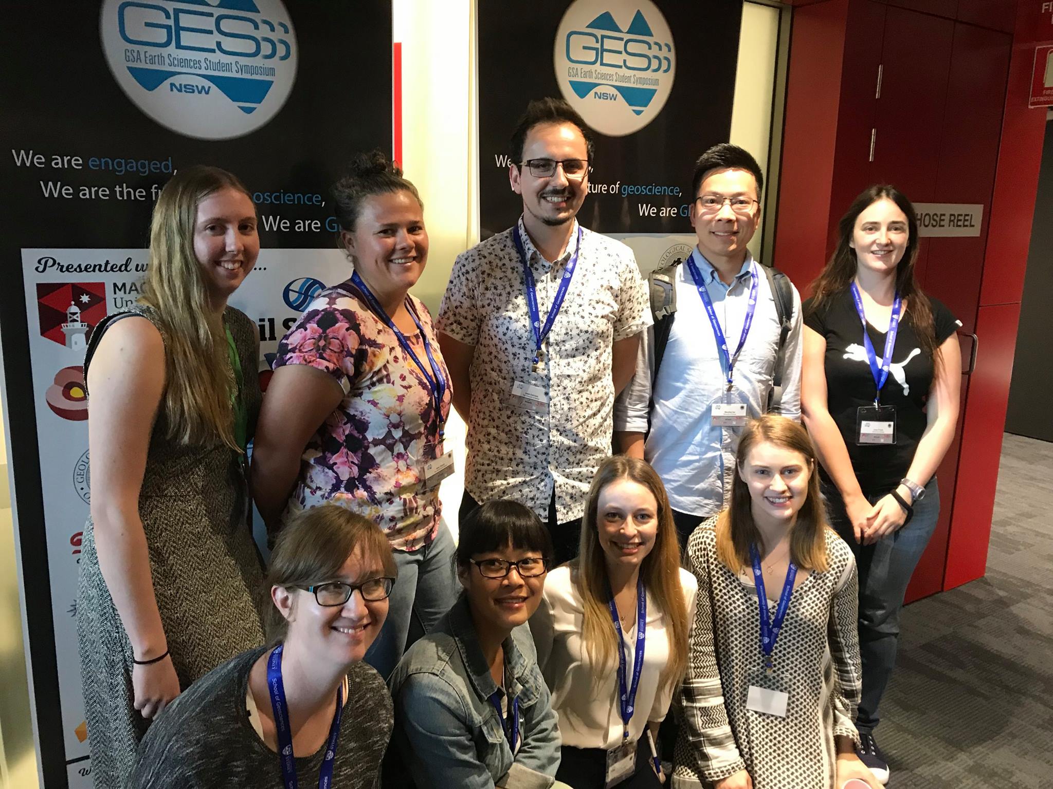
Congratulations to the EarthByte students who recently represented the School of Geosciences, University of Sydney at the student-run GSA Earth Sciences Student Symposium (GESSS) NSW conference. The event aims to bring together Honours, Masters and PhD students from across NSW to present and discuss their research in a relaxed, supportive environment; a primary goal of GESSS is … Read more…
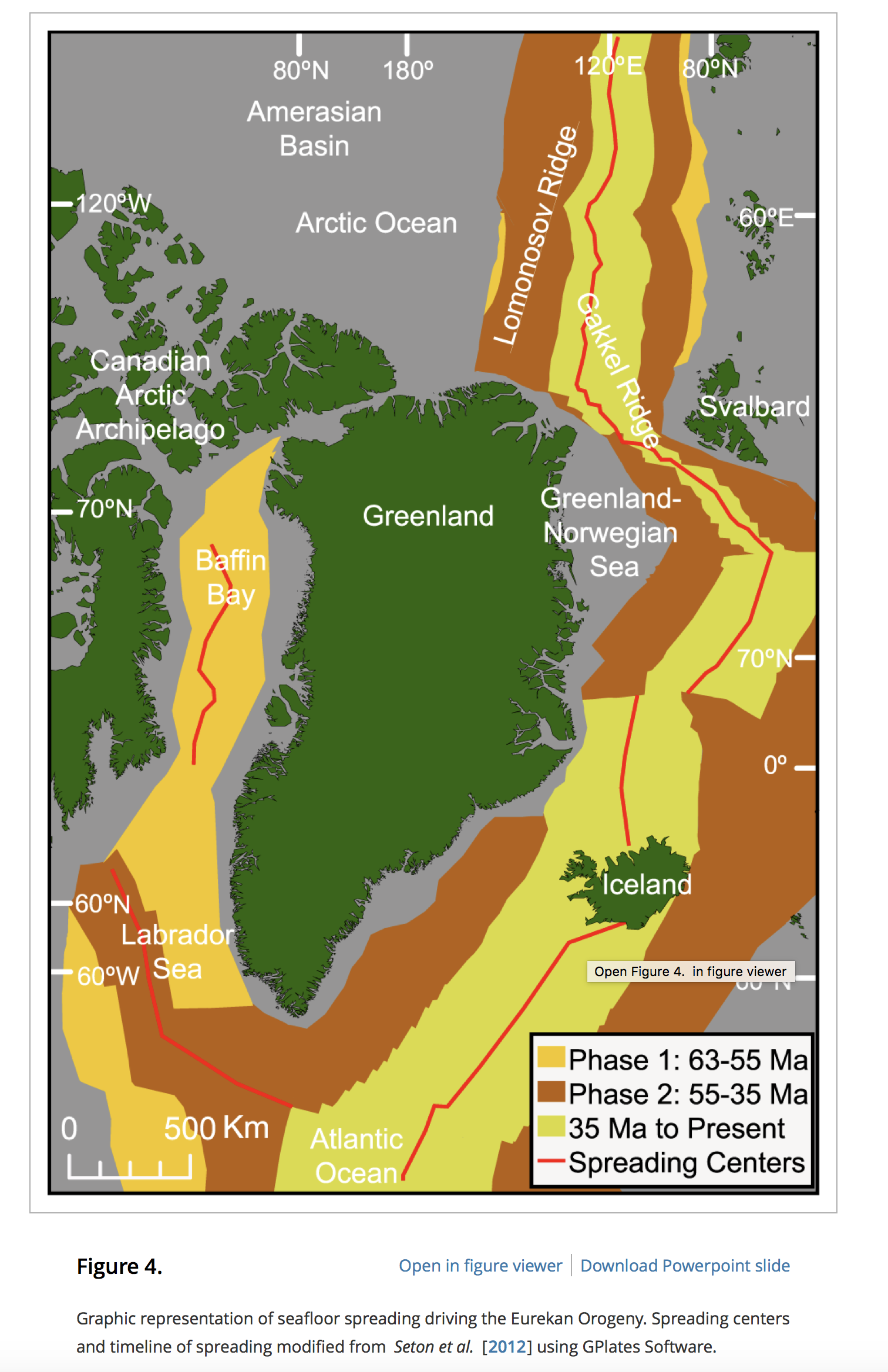
Author List: Austin Gion, Simon Williams, Dietmar Müller Citation: Gion, A.M., Williams, S.E. and Müeller, R.D., 2017. A reconstruction of the Eurekan Orogeny incorporating deformation constraints. Tectonics, 36(2), pp.304-320. Abstract: The Eurekan Orogeny records Paleogene convergence between Greenland and the Canadian Arctic. The complexity of the region, well represented by the disputed magnitude of Cenozoic sinistral displacement of … Read more…
Author List: Sarah MacLeod, Simon Williams, Kara Matthews, Dietmar Müller and Xiaodong Qin Citation: MacLeod, S.J., Williams, S.E., Matthews, K.J., Müller, R.D. and Qin, X., 2017. A global review and digital database of large-scale extinct spreading centers. Geosphere, pp.GES01379-1. Abstract: Extinct mid-ocean ridges record past plate boundary reorganizations, and identifying their locations is crucial to developing a better understanding of the … Read more…
Author List: Andrew Merdith, Simon Williams, Dietmar Müller & Alan Collins. Citation: Merdith, Andrew & Williams, Simon & Müller, Dietmar & Collins, Alan. (2017). Kinematic constraints on the Rodinia-Gondwana transition. Precambrian Research. 299. . 10.1016/j.precamres.2017.07.013. Abstract: Earth’s plate tectonic history during the breakup of the supercontinent Pangea is well constrained from the seafloor spreading record, but evolving plate configurations during … Read more…
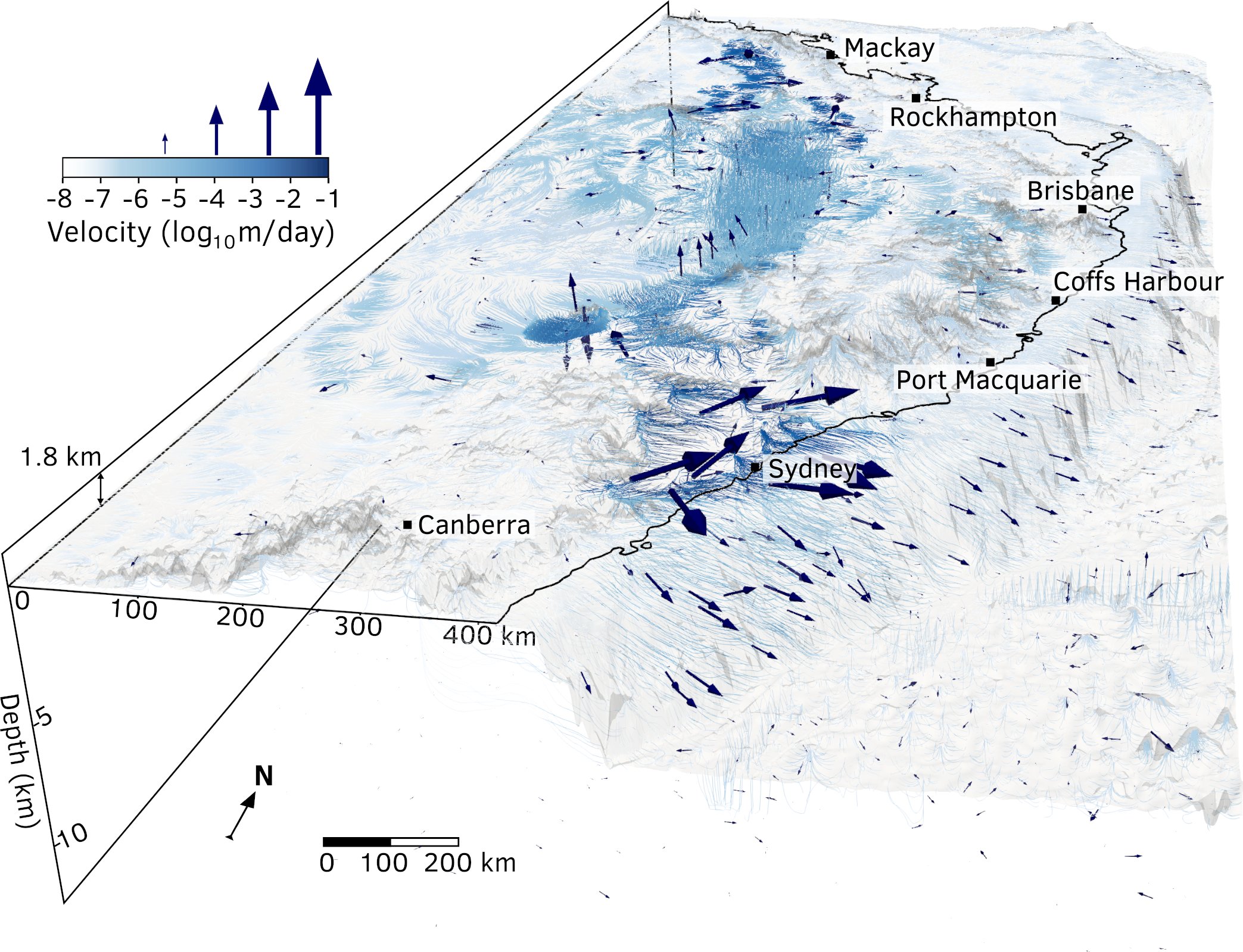
Author List: Tristan Salles, Nicolas Flament & Dietmar Müller. Citation: Salles, Tristan & Flament, Nicolas & Müller, Dietmar. (2017). Influence of mantle flow on the drainage of eastern Australia since the Jurassic Period. Geochemistry, Geophysics, Geosystems. 18. . 10.1002/2016GC006617. Abstract: Recent studies of the past eastern Australian landscape from present-day longitudinal river profiles and from mantle flow models … Read more…
Author List: Nicholas Barnett-Moore, Rakib Hassan, Dietmar Müller, Simon Williams & Nicolas Flament. Citation: Barnett-Moore, Nicholas & Hassan, Rakib & Müller, Dietmar & Williams, Simon & Flament, Nicolas. (2017). Dynamic topography and eustasy controlled the paleogeographic evolution of northern Africa since the mid Cretaceous. Tectonics. . 10.1002/2016tc004280. Abstract: Northern Africa underwent widespread inundation during the Late Cretaceous. Changes … Read more…
Author List: Patrice Rey, Luke Mondy, Guillaume Duclaux, Christian Teyssier, Donna Whitney, Marie Bocher, cécile Prigent. Citation: Rey, Patrice & Mondy, L & Duclaux, G & Teyssier, Christian & Whitney, Donna & Bocher, Marie & Prigent, cécile. (2017). The origin of contractional structures in extensional gneiss domes. 45. 263-266. 10.1130/G38595. Abstract: The juxtaposition of domains of shortening and extension at different … Read more…
The Encyclopedia of Marine Geosciences was selected for the 2017 Mary B. Ansari Best Geoscience Research Resource Work Award of The Geoscience Information Society (GSIS). The formal award will be given at the GSA 2017 conference in October in Seattle/USA. EarthByters Dietmar Muller and Maria Seton contributed two chapters on “Paleophysiography of Ocean Basins” and “Plate Motion”. This Encyclopedia … Read more…
Extension velocities along Pangea’s Triassic-Cenozoic rift systems. Each circle depicts the rift velocity of one passive margin point in terms of circle colour and size. Visit the interactive virtual rift globe here.
Extension velocities along Pangea’s Triassic-Cenozoic rift systems. Each circle depicts the rift velocity of one passive margin point in terms of circle colour and size. Visit the interactive virtual rift globe here.
In this numerical model of landscape evolution we impose over 2 million of years deformation produced with the Underworld software over an initial flat surface, ie a 256 km square box at a resolution of 1 km. On top of the deformed surface, a landscape evolution model, Badlands, is used to simulate both hillslope and … Read more…
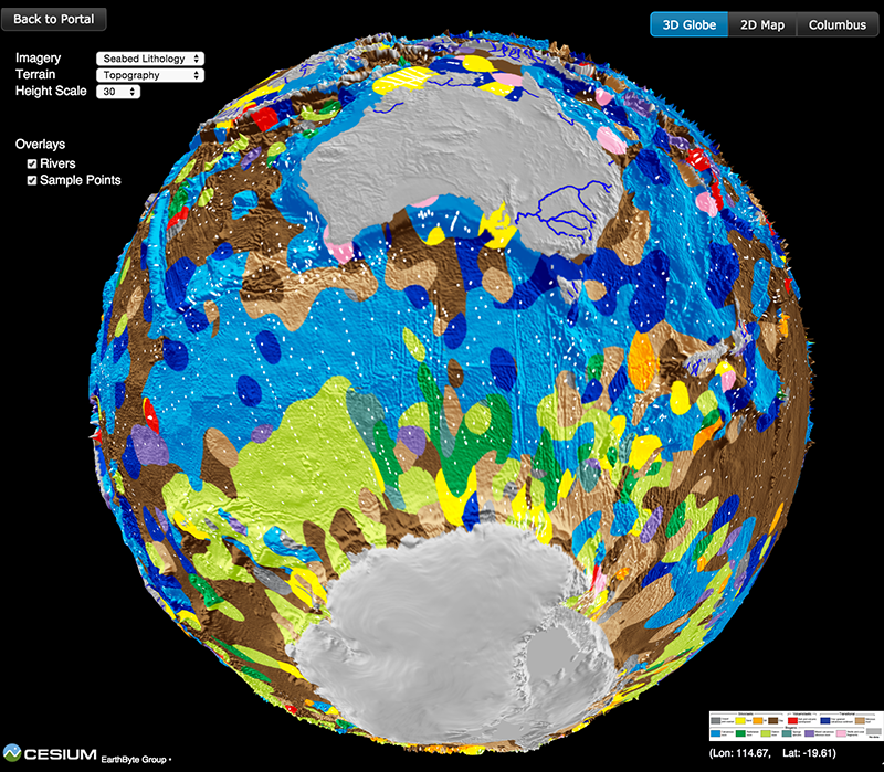
This spinning virtual seafloor geology globe is composed of a set of screen captures of an interactive digital globe portraying the distribution of different seafloor sediments available at the Gplates Portal.Citation Dutkiewicz, A., Müller, R. D., O’Callaghan, S., & Jónasson, H. (2015). Census of seafloor sediments in the world’s ocean. Geology, G36883-1. doi: 10.1130/G36883.1.Download paper … Read more…
This spinning virtual seafloor geology globe is composed of a set of screen captures of an interactive digital globe portraying the distribution of different seafloor sediments available at the Gplates Portal.Citation Dutkiewicz, A., Müller, R. D., O’Callaghan, S., & Jónasson, H. (2015). Census of seafloor sediments in the world’s ocean. Geology, G36883-1. doi: 10.1130/G36883.1.Download paper … Read more…
Citation Heine, C., Müller, R. D., Steinberger, B. and DiCaprio, L., 2010, Integrating deep Earth dynamics in paleogeographic reconstructions of Australia, Tectonophysics, 483, 135-150. View other EarthByte animations on our YouTube channel
This model shows the evolution of a continental rift from inception to breakup, using the Underworld numerical modelling framework. The left and right walls of the model are pulled apart from each other at a total rate of 2 cm/yr to induce rifting.Courtesy of Luke Mondy, EarthByte.View other EarthByte animations on our YouTube channel
