Continental breakup triggered massive CO2 emissions

Currently, human activity is the primary driver of elevating atmospheric CO2, but the Earth fluctuated from greenhouse to icehouse conditions and back long before humans existed. The question is:  what triggered these long-term climate cycles? Now research at the University of Sydney’s EarthByte Group, in collaboration with the German Research Centre for Geosciences, reveals how … Read more…

Age, spreading rates and spreading asymmetry of the world’s ocean crust

agegrid_ageerror_2008 rategrid_asymgrid_2008
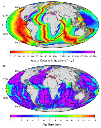
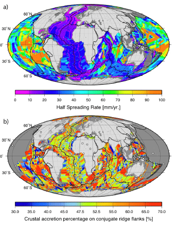
We present four companion digital models of the age, age uncertainty, spreading rates and spreading asymmetries of the world’s ocean basins as geographic and Mercator grids with 2 minute resolution. The grids include data from all the major ocean basins as well as detailed reconstructions of back-arc basins.

The age, spreading rate and asymmetry at each grid node is determined by linear interpolation between adjacent seafloor isochrons in the direction of spreading. Ages for ocean floor between the oldest identified magnetic anomalies and continental crust are interpolated by geological estimates of the ages of passive continental margin segments. … Read more…

Share

Integrating deep-Earth and surface processes for frontier-basin exploration

Project Summary
Sea level has changed by up to 300m through geological time. These fluctuations, caused by plate tectonics and convection in the Earth’s mantle, have created vast sedimentary basins and associated resources such as petroleum, natural gas and coal.

In this project, we propose to bring together global 4D databases with cutting-edge 3D numerical simulations to reconstruct how mid-ocean ridge creation and the recycling of old, cold oceanic plates into the mantle have driven surface topography and sea-level change globally since the breakup of the super-continent Pangaea. … Read more…

Share

Testing hotspot fixity in the Indian and Atlantic oceans

Project Summary
We have developed a novel interactive evolutionary inversion approach for computing absolute tectonic plate motions and their uncertainties based on hotspot tracks through time. We use a modified criterion of fit for inverting hotspot-track data, following an approach previously developed by Chang and co-workers for relative plate motions. Using this method, we derive covariance matrices for absolute plate rotations for the last 120 million years for the first time, using dated hotspot tracks in the Atlantic-Indian oceans. This represents a major advance in quantitatively constraining paleogeographic maps for the last 130 million years.  … Read more…

Share

Geomagnetism

Project Summary Derivation of Earth’s magnetic field as measured at satellite altitude and implications for Earth evolution, resource exploration, and environmental studies. Funding Agency World University Network for Geomagnetism Project Participants Prof David Gubbins Prof Dietmar Müller Dr David Ivers Prof Denis Winch Related Projects Virtual Geological Observatory Gondwanaland Evolution

Earth’s magnetic field

Project Summary
The magnetic field measured by satellites has 3 distinct sources: the dynamo in the liquid core, magnetised rocks near the Earth’s surface, and the external, solar terrestrial environment. It is difficult to separate out the large-scale field (originates in the earth’s core) from the small-scale, permanent field (originates in the earth’s crust). This project aims to develop physical theories for the origin of each field to aid separation, accompanied by comparison with satellite data and iterative improvements. It is envisaged that this project will extend our knowledge of the core field to unprecedented fine resolution while establishing the larger scales of the crustal field.  … Read more…

Share

Earth's magnetic field

Project Summary
The magnetic field measured by satellites has 3 distinct sources: the dynamo in the liquid core, magnetised rocks near the Earth’s surface, and the external, solar terrestrial environment. It is difficult to separate out the large-scale field (originates in the earth’s core) from the small-scale, permanent field (originates in the earth’s crust). This project aims to develop physical theories for the origin of each field to aid separation, accompanied by comparison with satellite data and iterative improvements. It is envisaged that this project will extend our knowledge of the core field to unprecedented fine resolution while establishing the larger scales of the crustal field.  … Read more…

Share

The global fracture zone and magnetic lineation data base project

Project Summary
Plate kinematic models derive from the detailed identifications of conjugate magnetic isochron picks and fracture zones (FZ). These data form the foundation of all relative marine plate tectonic reconstructions and codify our understanding of Earth’s surface evolution since the Mesozoic. Furthermore, FZ traces have extensive uses in many other marine geophysical investigations such as studying the origins of transform fault offsets, identifying seamounts and isolating abyssal hill roughness within fracture zone provinces, examining predictions from competing thermal models of the lithosphere, and much more. Kinematic models also require temporal information and this dimension is provided by identification of key magnetic isochron boundaries from total field magnetic anomalies collected along ship tracks. … Read more…

Share

Planet scale reorganisations of the plate-mantle system

Project Summary
Global climate change and shrinking resources have heightened our sense of dependence on the earth as a dynamic and complex system. This project aims to provide a unifying context for enhancing our understanding and appreciation of the workings of the inner earth and, in particular, its complex system behaviour during major tectonic events. … Read more…

Share

High resolution reconstruction of the Central and Eastern Indian Ocean

Project Summary
Plate reconstruction models for the rifting and separation of Gondwanaland’s conjugate margins continue to be poorly constrained. We propose to develop a new, high-resolution plate model for the central and eastern Indian ocean by synthesizing old and new geological and geophysical data utilizing combined French and Australian advanced software for magnetic anomaly modeling and plate tectonic reconstructions. We will test alternative continental fit reconstruction hypotheses by using a variety of reconstructed data sets. Such a joint research is timely, as the Indian Ocean continental margins become the focus of intense oil and gas exploration.  … Read more…

Share

The subduction reference framework: Unravelling the causes of long-term sea-level change

Project Summary
Sea level has fluctuated by up to 300 m through geological time, creating vast sedimentary basins and associated natural resources. We will use Earth’s subduction history as imaged by seismic tomography to establish a subduction reference framework for the past 200 million years, tracking all tectonic plates in both latitude and longitude. 4D numerical mantle-plate tectonic simulations (3D plus time) will reconstruct how the recycling of old, cold oceanic plates into the mantle have influenced surface topography and sea-level change since the breakup of the supercontinent Pangaea.  … Read more…

Share

Integration of plate kinematic reconstructions in geodynamic models of mantle convection

Project Summary
Despite more than 30 years of plate tectonics research, we still do not know exactly what drives the plates or controls the time-dependence of mantle convection. Plate motions are linked to processes in the deeper Earth interior by complex, enigmatic cause-and-effect relationships. While mantle convection is generally accepted as the underlying cause of plate motions, the geometry of mantle flow and its relation to plate motions remains poorly understood. As plate tectonics is the Earth Science paradigm, breakthroughs in this field affect understanding of all branches of Earth Science including formation and distribution of natural resources, long-term climate change and natural hazards. … Read more…

Share

Integrating global multidimensional datasets to underpin subduction process modelling during the past 60 million years

Project Report
Understanding the initiation and processes governing subduction remains one of the greatest challenges in geodynamics. Subduction processes affect every aspect of the Earth system, from its control on the thermal and chemical state of the mantle, to its recycling of oceanic lithosphere, sediments, water and volatiles, to its affect on the atmosphere, hydrosphere, biosphere and solid Earth through earthquakes and volcanic eruptions. Moreover, subduction is generally agreed to be one of the primary driving forces of plate tectonics and mantle convection through slab pull and the addition of raw materials into the mantle. … Read more…

Share

Constructing a tectonic framework for Ocean Drilling at high latitudes

Project Summary
Currently a major Ocean Drilling Program (ODP) campaign south of Australia is being carried out, comprising nine drilling legs. We propose to create a tectonic and paleogeographic framework for interpreting, modelling and synthesising these data. A joint analysis of Arctic and Antarctic regions will bring together a group of researchers from the Universities of Ottawa/Canada, California at San Diego/USA and Sydney to integrate data and models for the evolution of polar ocean basins and margins. The project will strengthen our ties with centres of excellence in polar geoscience and help to maximise the return for Australia’s investment in ODP.  … Read more…

Share

Seafloor spreading around Australia

(a) Abstract
The Australian Plate has undergone major changes in plate boundary geometry and relative plate velocities since the breakup of Gondwanaland. We illustrate the history of seafloor spreading around Australia by reconstructing gridded ocean floor ages and plate boundary configurations in a fixed Australian reference frame. In the Argo Abyssal Plain, seafloor spreading started at M25 dated as 154.3 Ma Late Jurassic (Oxfordian). The onset of seafloor spreading west of Australia at ~136 Ma marks the breakup between Greater India and Australia. Roughly at the same time, long-lived subduction east of Australia ceased, probably due to subduction of the Phoenix-Pacific spreading ridge, changing this plate boundary to a transform margin. … Read more…

Share

Numerical Modeling of Archean Tectonic Regimes by 2-Dimensional Finite Element Code

Project Summary
Many lines of evidence suggest that heat loss from the earth should have been significantly greater in the Archean. The presence of high temperature komatiites, greater radiogenic heat production and heat from the secular cooling of the earth all imply higher mantle temperatures in the Archean. However, these lines of evidence are difficult to reconcile with Archean metamorphic PT data, diamond thermobarometry, mantle xenoliths in kimberlites, the ominous lack of minimum melting granites and estimates for crustal thickness which all suggest that geothermal gradients in the Archean, at least on the continents, were not very different from today. This paradox presents problems for reconstructing Archean tectonic processes and environments.  … Read more…

Share

Seafloor imaging east and south of Australia

Project Summary
Data from three recent cruises on N.O. L’Atalante are used in collaboration with AGSO to use backscatter and bathymetry data for seafloor classification, and to reconstruct the tectonic and sedimentary history of selected areas, also based on 3.5 kHz, seismic reflection, gravity and magnetic data.

Sponsors
Australian Geological Survey Organization
Environment Australia  … Read more…

Share

The Mid-Cretaceous seafloor spreading pulse: fact or fiction?

Project Summary
A major debate in Geoscience is centred on the hypothesis that a massive pulse of rapid seafloor spreading occurred during the mid-Cretaceous (~120-80 Ma). It has been suggested that such a pulse caused prolonged magnetic field stability, large igneous provinces, a sea-level highstand, variations in atmospheric CO2 and anoxia, but doubts have been raised about its existence. We propose to test this hypothesis by creating complete palaeo-seafloor age grids for the last 130 m.y. They will serve as input for 3-D spherical convection models, whose output will be groundtruthed by plate kinematics, results from mantle tomography and by the uplift-subsidence history of cratons.  … Read more…

Share