 Citation
Heine, C., Yeo, L. G., & Müller, R. D. (2015). Evaluating global paleoshoreline models for the Cretaceous and Cenozoic. Australian Journal of Earth Sciences, (ahead-of-print), 1-13., doi: 10.1080/08120099.2015.1018321.
Summary
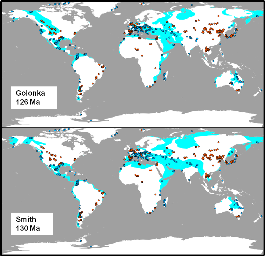
Paleoshoreline maps represent the distribution of land and sea through geologic time. These compilations provide excellent proxies for evaluating the contributions non-tectonic vertical crustal motions, such as mantle convection-driven dynamic topography, to the flooding histories of continental platforms. Until now, such data have not been available as a globally coherent compilation. Here, we present and evaluate a set of Cretaceous and Cenozoic global shoreline data extracted from two independent published global paleogeographic atlases. We evaluate computed flooding extents derived from the global paleoshoreline models with paleoenvironment interpretations from fossils and geological outcrops and compare flooding trends with published eustatic sea level curves.
Although the implied global flooding histories of the two models are similar in the Cenozoic, they differ more substantially in the Cretaceous. This increase in consistency between paleoshorelines maps with the fossil record from the Cretaceous to the Cenozoic likely reflects the increase in the fossil preservation potential in younger geological times. Comparisons between the two models and the Paleogeographic Atlas of Australia on a regional scale in Australia, reveal higher consistency with fossil data for one model over the others in the mid-Cretaceous, and suggests that a review of the Late Cretaceous–Cenozoic paleogeographic interpretations may be necessary. The paleoshoreline maps and associated paleobiology data constraining marine versus terrestrial environments are provided freely as reconstructable GPlates-compatible digital files, and form a basis for evaluating the output of geodynamic models predicting regional dynamic surface topography.
Downloads
Download the paper – pdf
Download the Paleoshoreline data files from Github
Correction
Reference to the work of Jan Golonka should be:
Golonka, J. 2009. Phanerozoic paleoenvironment and paleolithofacies maps: Cenozoic. Geologia/Akademia Górniczo-Hutnicza im. Stanisława Staszica w Krakowie, 35 (4), 507-587.
Golonka, J. 2007. Phanerozoic paleoenvironment and paleolithofacies maps: Mesozoic. Geologia/Akademia Górniczo-Hutnicza im. Stanisława Staszica w Krakowie, 33 (2), 211-264.
Contact
Any questions, please email: dietmar.muller@sydney.edu.au
License
![]() This work is licensed under a Creative Commons Attribution-NonCommercial-ShareAlike 4.0 International License
This work is licensed under a Creative Commons Attribution-NonCommercial-ShareAlike 4.0 International License
![]()
