🚀 pyBacktrack 1.5 is now released!
The new release makes pyBacktrack easier to install and expands its capabilities for backtracking, backstripping, paleobathymetry reconstruction, dynamic topography, sea-level modelling, and drill-site reconstructions.
Users can now install pyBacktrack using:
pip install pybacktrack
conda install pybacktrack
docker pull earthbyte/pybacktrack
What’s new in pyBacktrack 1.5?
The release adds conda installation support and several major workflow improvements, including the ability to output reconstructed drill-site locations, specify custom decompaction output ages, and merge externally generated “traditional” paleobathymetry with pyBacktrack reconstructions to fill gaps on subducted crust.
The default reconstruction model has also been updated from Müller et al. 2019 to Zahirovic et al. 2022, with support for both mantle and paleomagnetic reference frames.
New model additions include:
🌍 Dynamic topography models
• Braz2021
• Young2022
🌊 Sea-level models
• Miller2024
• Haq2024
• Haq2024 long-term
The release also includes new supplementary scripts and updated example notebooks, including a workflow for reconstructing drill sites through time and displaying them on reconstructed paleobathymetry.
Documentation has been updated, and the full release notes are available here:
https://github.com/EarthByte/pyBacktrack/releases/tag/v1.5.0
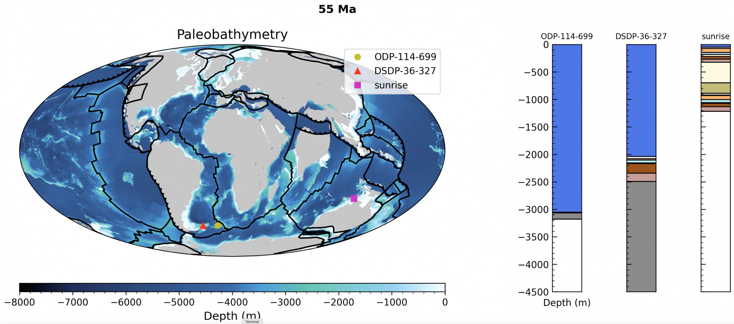
This video displays the reconstruction of three drill sites displayed on top of paleobathymetry. The drill sites and paleobathymetry were reconstructed using the Alfonso et al. (2024) plate model from 0 to 170 Ma, a global model including tomotectonic reconstructions of western North America based on Clennett et al. (2020). Paleobathymetry was reconstructed for preserved ocean floor using pyBacktrack and merged with forward modelled paleobathymetry on subducted crust. Each reconstructed drill site location is represented by a coloured symbol. Two sites on continental crust are “DSDP-36-327” (red triangle) and the “sunrise” exploration well (purple square). The site on oceanic crust is “ODP-114-699” (yellow circle). The “sunrise” site was backstripped (instead of backtracked) because it has a record of paleo water depths and hence does not need a model of tectonic subsidence to infer them. The animation displays the compaction of stratigraphic layers at each drill site through time. As new layers are deposited over time the underlying layers compact. The first layer represents the water depth (rendered in blue). Then the individual stratigraphic layers are rendered with a set of hardwired colours that are repeated (if there are more layers in the drill site than hardwired colours). Finally, the basement layer (from bottom of drill site to basement depth) is rendered in grey. A basement layer only exists if the total sediment thickness (at the drill site) is deeper than the drill site. A basement layer is more likely to exist (and likely to be thicker) at continental drill sites because the default total sediment thickness grid is not as accurate near continental margins (compared to deeper ocean basins).
![]()
