 Congratulations to Prof Dietmar Müller, Dr Nicolas Flament, Dr Kara Matthews, Dr Simon Williams, and Prof Michael Gurnis on their paper recently published in Earth and Planetary Science Letters. Their paper, Formation of Australian continental margin highlands driven by plate-mantle interaction, has featured in a variety of Australian and international media outlets.
See the list of online media below:
Kosciuszko explained: mystery of the Snowy Mountains solved – Sydney Morning Herald
Geologists discover how Australia’s highest mountain was created – ScienceDaily
The Creation of Kosciusko – Australasian Science
Geologists discover how Australia’s highest mountain was created – NCI
Origins Of Australia’s Mountains Finally Explained – IFL Science
Mystery of Highest Aussie Mountain Solved – Quarry Magazine
Why does Australia’s highest mountain exert such a gravitational pull? – The Learning Press
Geologists discover how Australia’s highest mountain was created – Geology IN
Kosciuszko explained: mystery of the Snowy Mountains solved – Thredbo
Media Release:
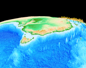
Geologists from the University of Sydney and the California Institute of Technology have solved the mystery of how Australia’s highest mountain – Mount Kosciusko – and surrounding alps came to exist.
Most of the world’s mountain belts are the result of two continents colliding (including the Himalayas) or volcanism. The mountains of Australia’s Eastern highlands – stretching from north-eastern Queensland to western Victoria – are an exception. Until now no one knew how they formed.
A research team spearheaded by Professor Dietmar Müller from the University’s School of Geosciences used high performance computing code to investigate the cause of the uplift which created the mountain range. The team found the answer in the mountains’ unusually strong gravity field.
“The gravity field led us to suspect the region might be pushed up from below so we started looking at the underlying mantle: the layer of rock between the Earth’s core and its crust,” said Professor Müller.
The team found the mantle under Australia’s east coast has been uplifted twice.
The first occurred during the Early Cretaceous Period, when Australia was part of Gondwanaland.
Over earth’s lifespan or ‘geological time’ the largely solid mantle has continuously been stirred by old, cold tectonic plate sections sinking into the deep mantle, under another plate. This process, called subduction, was occurring during the Early Cretaceous Period.
“Eastern Australia was drifting over a subducted plate graveyard, giving it a sinking feeling,” said co-author Dr Kara Matthews, a former PhD candidate at the University now at the University of Oxford. “But around 100 million years ago subduction came to a halt, resulting in the entire region being uplifted, forming the Eastern Highlands.”
The next 50 million years was a time of relative inactivity.
“Then, about 50 million years ago Australia’s separation from Antarctica accelerated and it started moving north-northeast, gradually taking it closer to a vast mantle upwelling called the South Pacific Superswell,” said co-author Dr Nicolas Flament. “This provided a second upward push to the Eastern Highlands as they gradually overrode the edge of the superswell.”
Professor Müller said the two-phase uplift suggested by supercomputer models is well-supported by geological features from rivers in the Snow Mountains, where river incision occurred in two distinct phases.
“The model we built explains why the iconic Australian Alps exist and is also a new mechanism for figuring out how some other mountainous regions elsewhere in the world were formed.”
The team’s findings have been published in Earth and Planetary Sciences.
A new interactive globe is now available on the GPlates Web Portal that allows you to view dynamic topography through time of a geodynamic model that was used in the research.
![]()
