EarthByte has now released a list of Honours projects to be offered in 2017. These projects are outlined below.
If you are interested in learning more about any of these projects, please get in contact with the project supervisors.
Oceanic gateways: a primary control on global climate?
Supervisors: Maria Seton, Simon Williams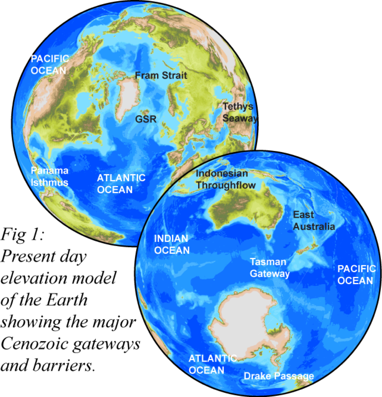
In 1578 the English privateer, Sir Francis Drake, inadvertently discovered a narrow passageway between the southern tip of South America and Antarctica. This was an exciting discovery of one of the world’s most important navigational passageways, connecting the Atlantic and Pacific oceans. In the 20th century, interest was reignited in this narrow passageway and other similar connections between ocean basins. Scientists identified such regions, termed oceanic gateways, as focal areas driving large-scale changes to the entire planetary system, from global climate and ocean circulation to species diversity. Their changing morphology over tens of millions of years was linked directly to plate tectonic
processes. However, the primary role of oceanic gateways in modulating global climate was challenged by the idea that the concentration of atmospheric CO2 is instead the dominant control. This project aims to constrain the role of tectonics on ocean circulation and global climate, particularly to differentiate between the two competing ideas and assess their relative importance. This will have major implications for determining the factors driving the change from a “Greenhouse World” 55 million years ago to our current “Icehouse World”.
Several honours projects are being offered as part of this project to develop state-of-the-art palaeo-bathymetries of oceanic gateways, taking into account both lateral plate tectonic and vertical mantle-induced motions. These palaeo-bathymetries are necessary for assessing the relative role of gateways on global climate events and are an important boundary constraint for palaeoclimate simulations.
Project 1 – Vertical motions in the Scotia Sea
The Scotia Sea (Drake Passage) is the most well-known oceanic gateway, separating Antarctica from South America. The formation of this gateway has been linked to the inception of the Antarctic Circumpolar Current, Antarctic glaciation and the end of the “Greenhouse World” at the Eocene-Oligocene boundary. In this project, you will explore the relative role of long-wavelength dynamic topography and slab window formation on the vertical motions in the Scotia Sea, assess whether either of these processes can explain the observed anomalous topography and produce a new palaeobathymetry model for the area that will constrain the timing of deep-water flow. You will develop skills in plate tectonic and geodynamic modeling and data synthesis and learn software tools such as GPlates, ArcGIS and GMT. This project involves collaboration with colleagues from the University of Wollongong.
Project 2 – Miocene or Pliocene closure of the Panama gateway?
The Central American Seaway facilitated the exchange of water, heat, salinity and biota between the Pacific and Atlantic Oceans. The closure of this oceanic gateway, at the Isthmus of Panama, has been attributed to the onset of northern hemisphere glaciation, the formation of North Atlantic Deep Water and the great biotic exchange between North and South America during the Pliocene. However, recent studies have controversially proposed a Miocene age for gateway closure, which would require a rethink of our understanding of global ocean circulation patterns and biotic exchange. In this project, you will assess the two competing models for gateway closure by developing two alternative plate tectonic scenarios and producing corresponding paleobathymetries for the Central American Seaway, taking into account island arc growth, uplift and sealevel changes. Although this project does not involve a fieldtrip to the Caribbean, you will acquire new skills in plate tectonic modeling and data synthesis and become proficient in using software tools such as GPlates, ArcGIS and GMT.
Project 3 – Dynamic topography of oceanic gateways
 The topography of the continents and bathymetry of ocean basins is a first-order earth observation, largely shaped by plate tectonic processes. However, recent studies have highlighted the important role of the convecting mantle on large-scale surface topography and bathymetry. While quantifying this “dynamic topography” has previously been studied for sedimentary basins, continental margins and continental interiors, its role on the evolution of oceanic gateways has yet to be explored. In this project, you will examine a suite of dynamic topography data for all Cenozoic oceanic gateways to identify the timing and quantify the effect of dynamic topography in these areas. You will then explore whether dynamic topography can address previously unexplained associations between gateway opening changes in ocean circulation and climate associated with these gateways. As part of this project, you will acquire skills in working with plate tectonic and mantle convection datasets and in data synthesis and using software tools such as GPlates, python, ArcGIS and GMT. This project involves collaboration with colleagues from the University of Wollongong, and will be part of the global research stream of the Basin Genesis Hub.
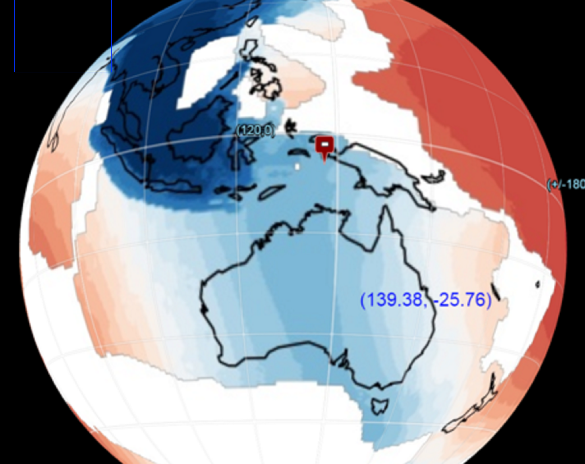
Vertical motions of the Tasman and Coral Sea: possible link to Ontong Java Plateau collision?
Supervisors: Maria Seton, Simon Williams
The collision of the world’s largest Large Igneous Province (LIP), the Ontong Java Plateau (OJP), with the Melanesian Arc has been proposed as the cause of a localised subduction polarity reversal event along the South Solomon Trench. This reversal is believed to have led to a cascade of events such as a change in direction of the Australian plate, ore-deposit formation along the Melanesian Arc, and possibly a reorganisation of the entire plate-mantle system. Although this major tectonic event is well-recognised in the literature, determining the timing of plateau accretion is difficult; three independent approaches (palaeomagnetics, marine geophysics and onshore geology) yield timings that differ by over 30 million years.
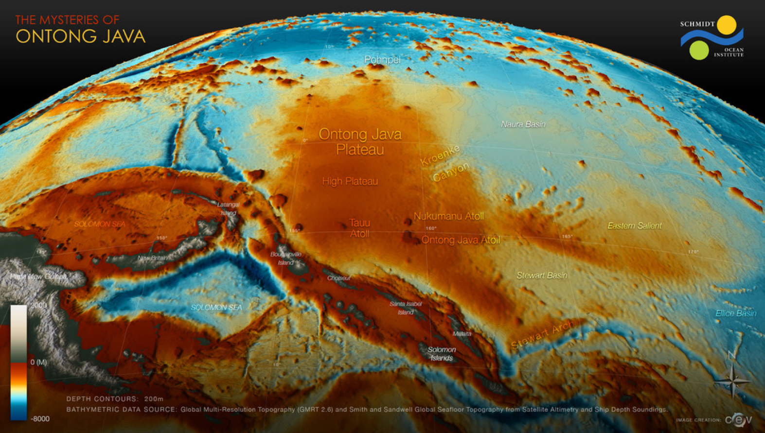 In this project, you will address this controversy using a novel and multi-disciplinary approach that explores the far-field effect of this collision on the vertical motions of the submarine ridges in the Tasman and Coral Seas. You will integrate age and paleo-environment data from sedimentary samples, including those collected from recent voyages IN2016_T01 on the RV Investigator and SS2013_v06 on the RV Southern Surveyor. You will then construct alternative plate kinematic models of the OJP collision in GPlates, which will be fed into geodynamic models of mantle structure and dynamic topography. Lastly, you will assess which coupled plate kinematic-geodynamic model best reflects the vertical motions predicted by your Tasman and Coral Sea samples.
The multi-disciplinary nature of this project means that you acquire skills in sedimentology, geophysical data analysis and computing, with a possible research visit to New Caledonia to work with sedimentologists on the recently collected samples. Software that you will use include: GPlates, ArcGIS and the Generic Mapping Tools. This project involves collaboration with colleagues from the University of Wollongong.
Newly discovered volcanic centres of northern Zealandia: part of an intra-plate volcanism pulse?
Supervisors: Kelsie Dadd, Maria Seton
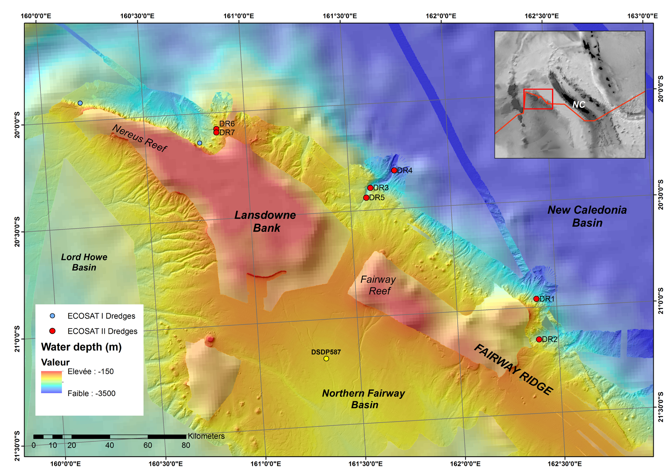 A defining characteristic of the southwest Pacific is the significant amount of continental crust distributed throughout the region, including the world’s largest submerged continental fragment, the Lord Howe Rise. While largely consisting of stretched continental crust and rift basins, the Lord Howe Rise has numerous intra-plate volcanoes. Some of this volcanism can be attributed to the migration of the Lord Howe Rise over a hotspot but the remainder displays no age-progression and instead may be related to a Cenozoic pulse of magmatism in the region. In June-July 2016, a research voyage led by the University of Sydney on the RV Investigator recovered samples of volcanic breccia and basalts from several sites along the Fairway Ridge, an uplifted portion of the northern margin of the Lord Howe Rise. In this project, you will assess the petrography and geochemical composition of these newly discovered intraplate volcanics, relate them to other intraplate volcanics of the Lord Howe Rise and assess their eruption in the context of tectonic and mantle events in the region.
As part of this project, you will acquire both analytical (petrographic and geochemical) and software skills (ArcGIS, GMT, GPlates), which will prepare you for working in the exploration industry, consulting firms, government agencies or universities.
Reconstructing the upwelling history of the global ocean from the Cretaceous to the present
Supervisors: Adriana Dutkiewicz, Dietmar Müller and Rakib Hassan
Zones of upwelling are inextricably linked to major oceanographic and climatic processes including the global heat budget and global wind patterns. Upwelling plays a critical role in ocean productivity, ocean anoxia, sequestration of organic carbon and deposition of hydrocarbon source rocks. For example, the highest levels of ocean productivity are associated with shallow eastern boundary regions of upwelling in Peru and Chile, Namibia, NW Africa, and Californian [e.g., Berger and Wefer, 2002] where the total organic carbon is usually > 5% by weight [e.g., Wefer et al., 1998]. Such organic-rich sequences occur over a wide stratigraphic range along continental shelves and within deep-sea sequences. The latter are often attributed to oceanic anoxic events (OAEs). The South Atlantic sedimentary sequence contains a record of seven Cretaceous (~ 145 – 65 Ma) OAEs during which organic-rich black shales were deposited under greenhouse conditions [Jenkyns, 2010]. Modelling suggests that upwelling may have played an important role in the deposition of the organic-rich marine sediments, even in the presence of ocean-wide anoxia [Handoh et al., 2003].
The aim of this project is to reconstruct the upwelling history of the ocean using the ATOM code, developed as a collaborative EarthByte project, which is designed to model surface atmospheric and ocean circulation through geological time in a plate tectonic context. In this project, Cretaceous-Cenozoic paleo-elevation maps will be used to model key time slices from 140 Ma to present-day. Results of the model will be compared to multi-proxy ocean productivity datasets including sedimentological and paleontological data such as total organic carbon content, opal flux, distribution of diatom and foraminifera species known to be associated with high productivity [Berger and Wefer, 2002], stable isotope measurements (δ18O, δ13C) of foraminifers and bulk sediment samples. These data sets will be obtained from the iCORDS database (EGI, Univ. of Utah) and from published deep-sea drilling results. The sensitivity analysis will be done for a small number of carefully chosen locations where the zones of upwelling have changed intensity or shifted over time. The project will be part of the global Basin Genesis Hub research stream.
References:
Berger, W. H., and G. Wefer (2002), On the reconstruction of upwelling history: Namibia upwelling in context, Marine Geology, 180(1), 3-28.
Handoh, I. C., G. R. Bigg, and E. J. W. Jones (2003), Evolution of upwelling in the Atlantic Ocean basin, Palaeogeography, Palaeoclimatology, Palaeoecology, 202(1), 31-58.
Jenkyns, H. C. (2010), Geochemistry of oceanic anoxic events, Geochemistry, Geophysics, Geosystems, 11(3).
Wefer, G., W. H. Berger, C. Richter, and Shipboard Scientific Party (1998), Facies patterns and authigenic minerals of upwelling deposits off southwest Africa, in Proceedings Ocean Drilling Program, Initial Reports, edited by G. Wefer, W. H. Berger and C. Richter, pp. 487-504.
The enigma of Sundaland’s Late Cretaceous to Eocene regional unconformity
Supervisors: Sabin Zahirovic, Tristan Salles, Mike Gurnis (Caltech), Dietmar Müller
Sundaland is a continental promontory that makes up the core of Southeast Asia, and has grown through the Phanerozoic via multiple accretionary events resulting from the convergence between the Eurasian, Indo-Australian and Pacific plates. The basins of Sundaland record global, regional and local influences of tectonics, dynamic topography and changing sea levels. Recent coupled models of plate reconstructions and mantle convection indicate a period of regional subsidence in the Early Cretaceous, followed by broad uplift in the Late Cretaceous to Eocene times. The dynamic uplift is synchronous with regional emergence, erosion and the development of unconformities in basins across the entire region. However, Sundaland became flooded again since 40 million years ago, despite falling long-term global sea levels. These observations are consistent with the dominance of dynamic topography acting on Sundaland. However, the role of basin rifting and surface processes in modulating basin histories has not yet been explored.
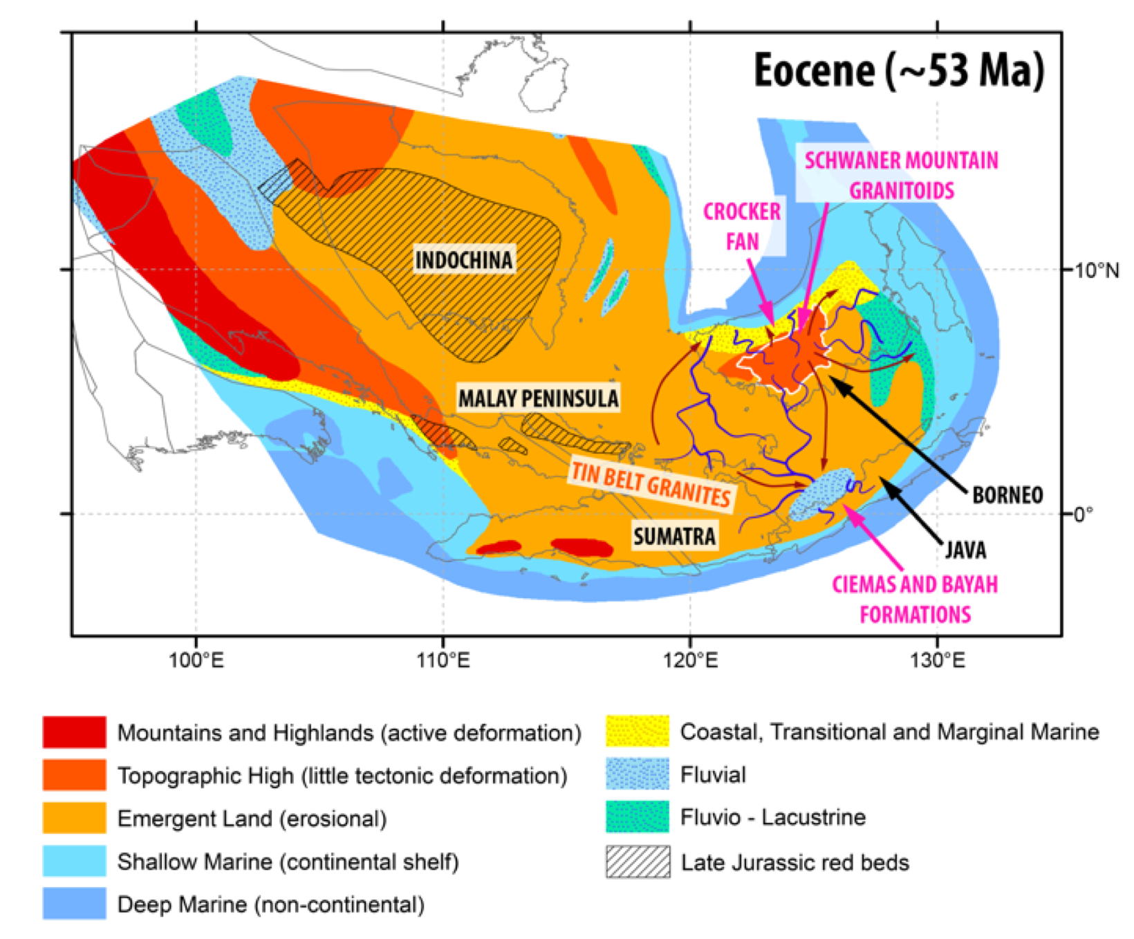 This project will use cutting-edge deforming plate reconstructions of Sundaland from GPlates, and couple it to surface process modelling using the new open-source Badlands code. By applying time-dependent topography from CitcomS mantle convection models, and varying end-member estimates of erodibility and precipitation, this project will provide insights into the erosional and depositional history in the basins of Sundaland. By using the latest open-source modelling approaches developed within the Basin GENESIS Hub, the project will explore the interplay between changing sea levels, rifting and dynamic topography on basin evolution.
Image: Paleogeographic reconstruction of Sundaland in the Eocene highlighting the dominance of erosional/non-depositional environments in Southeast Asia (Sabin Zahirovic).
Australia’s ancient inland sea: Evolution of the Eromanga Sea linkage to the (proto) Pacific Ocean during the Cretaceous
Supervisors: Sabin Zahirovic, Dietmar Müller, Tristan Salles, Rakib Hassan
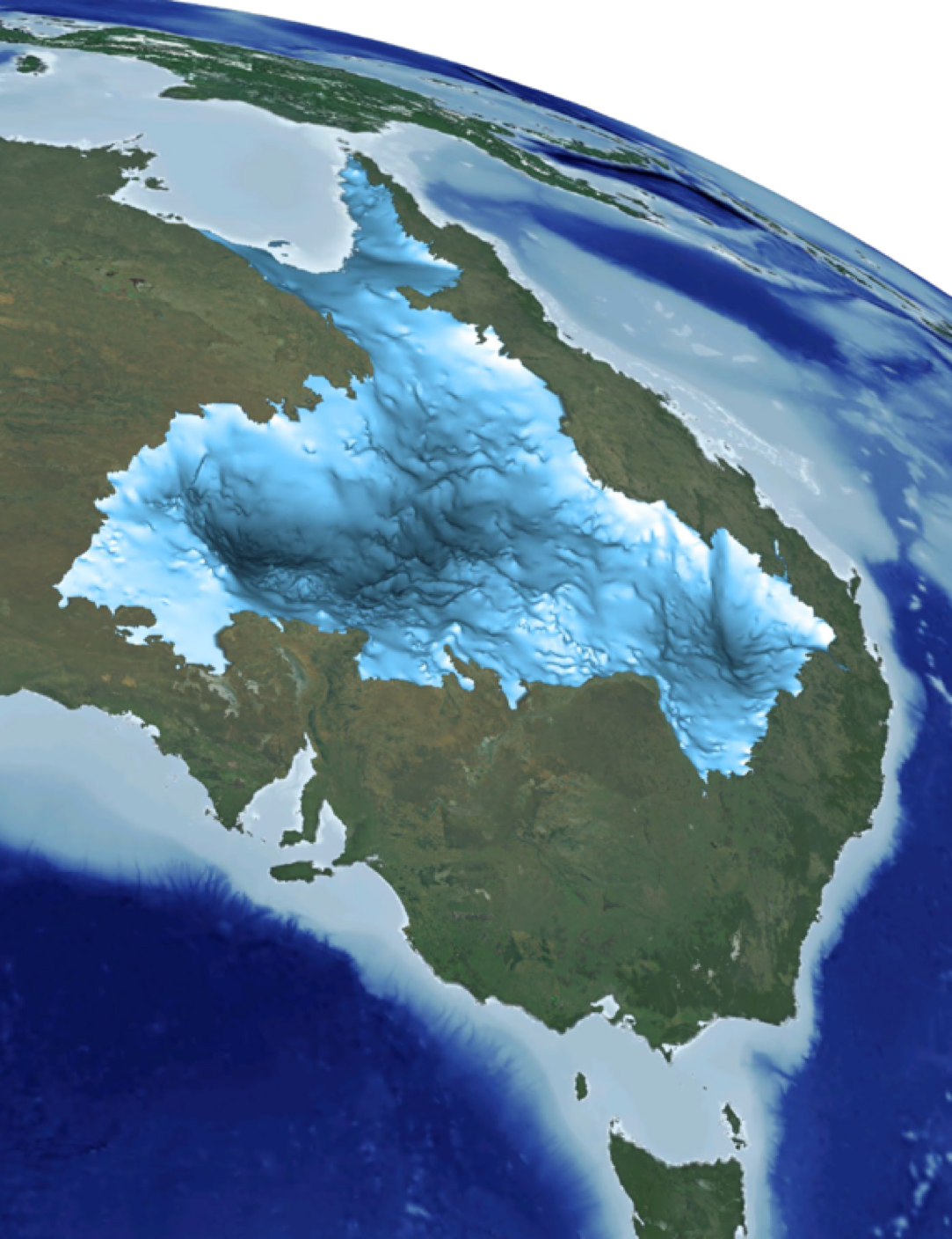 Australia’s geography has a long history of topographic change resulting from tectonism, sea level fluctuations and surface processes. Australia’s coastline 100 million years ago was markedly different to the present, with an extensive epicontinental sea covering the region that is presently occupied by the Great Artesian Basin in eastern Australia. This ancient Eromanga Sea was a shallow seaway that was generated through the combined effects of higher global sea levels and a dominant effect of dynamic topography acting on eastern Australia during the mid Cretaceous. Several generations of numerical modelling approaches have provided valuable insight into the evolution of the Eromanga Sea, and emerging technologies that incorporate surface processes of erosion and deposition are providing a new perspective on the accumulation of sediments in the Great Artesian Basin. However, due to the difficulties in constraining paleo-topography and uncertainties in the location and geometry of the eastern Australian subduction zone, existing models predict an Eromanga Sea linkage to the embryonic Southern Ocean rather than a northern connection to the (proto-) Pacific as required by the sedimentary and paleogeographic record.
This project will explore the evolution of the Eromanga Sea linkage to the Pacific by combining data from Geoscience Australia’s Paleogeographic Atlas and the recently-published Hydrogeological Atlas of the Great Artesian Basin with modern modelling approaches. The subduction zone location along eastern Australia and in the vicinity of the New Guinea margin will be modified using GPlates, and mantle flow models will be used to derive the evolution of dynamic topography. Published eustatic sea level curves will be combined with the dynamic topography predictions as boundary conditions to surface process models using Badlands, and end-member estimates of the paleo-topography, rainfall and erodibility will be incorporated to test whether the sedimentation history in the northern part of the Great Artesian Basin can be reproduced. As part of the Basin GENESIS Hub, this project will take advantage of cutting edge open-source technologies that link Earth processes across spatial and temporal scales to better understand the evolution of eastern Australia and New Guinea in a tectonic, geodynamic and surface process framework.
Image: Great Artesian Basin, Geoscience Australia
Evolution of Drainage Systems and Sediment Fluxes in Africa since 140 Ma
Supervisors: Rakib Hassan, Tristan Salles, Dietmar Müller
The slow northward motion of the African continent above a large-scale mantle upwelling over the past 200 Myr and Cenozo ic magmatism associated with mantle plumes have broadly shaped the tectonic history of the continent. The large-scale mantle upwelling under present-day southern Africa, also known as a large low shear velocity province (LLSVP), is responsible for the anomalous topography of southern Africa (Gurnis et al., 2000; Lithgow-Bertelloni and Silver, 1998). While Cenozoic volcanism and anomalous topographic swells in east Africa, stretching from northwestern Ethiopia to northern Tanzania, have been associated with mantle plumes (Ritsema et al., 1999). Passage of a continent above a mantle superswell can trigger continental-scale drainage reorganizations (Braun et al., 2014), while plume-related upwelling may also induce drainage reorganizations (Stankiewicz and de Wit, 2006), but at a regional scale. The space-time evolution of mantle- and tectonically-driven topography and their complex interaction with geomorphological processes, modulated by climate, provide first order controls on the production and deposition of sediments into basins and margins.
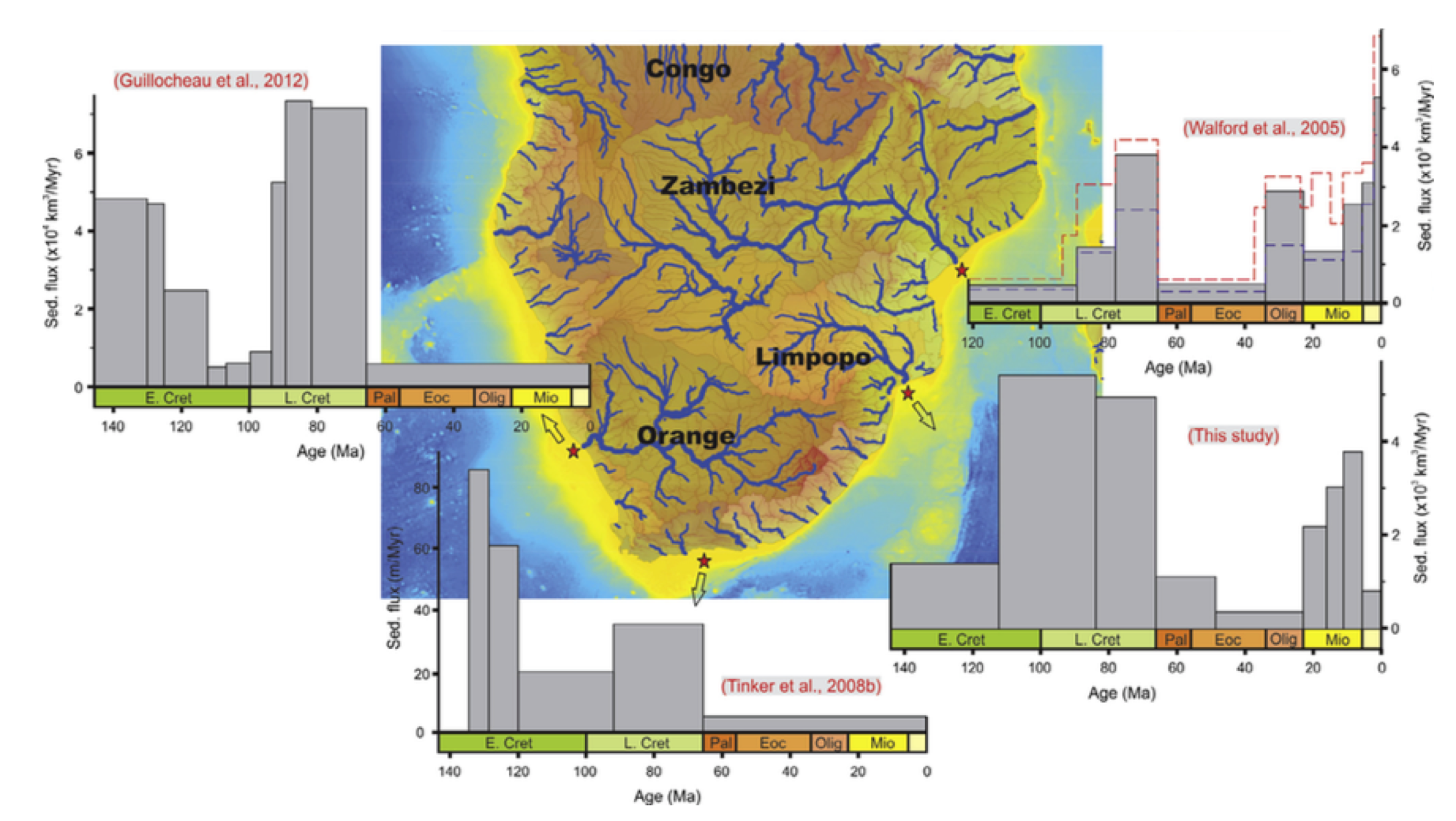 There are two very different end-member views of South African uplift, expressed in the papers by Wildman et al. (2015) and Paul et al. (2014) – either uplift was largely Cretaceous in age or Late Cenozoic.
Some researchers (Green et al., 2016; Said et al., 2015) have come to the conclusion that there were two events, but their relative magnitude and regional extent is uncertain. A combination of alternative mantle convection/tectonic models tried to surface process modeling and ground-truthed by observed river profiles and observed sediment accumulation in key basins and margins will help to distinguish between these end-member models, and be able to put bounds on the magnitude and spatial geometry of Cretaceous and late Tertiary uplift.
There are two very different end-member views of South African uplift, expressed in the papers by Wildman et al. (2015) and Paul et al. (2014) – either uplift was largely Cretaceous in age or Late Cenozoic.
Some researchers (Green et al., 2016; Said et al., 2015) have come to the conclusion that there were two events, but their relative magnitude and regional extent is uncertain. A combination of alternative mantle convection/tectonic models tried to surface process modeling and ground-truthed by observed river profiles and observed sediment accumulation in key basins and margins will help to distinguish between these end-member models, and be able to put bounds on the magnitude and spatial geometry of Cretaceous and late Tertiary uplift.
This project will develop and apply workflows to generate realistic patterns of erosion and sediment deposition for the African continent. Tectonically-driven topography will be obtained based on state-of-the-art deforming plate models, using the GPlates software and mantle-driven topography will be obtained from a number of paleogeographically constrained numerical models of mantle convection. These space-time varying uplift/subsidence patterns will be used to drive numerical geomorphology models (BADLANDS), in order to obtain erosion/deposition patterns over the last 140 Ma. The resulting erosion/deposition patterns and space-time varying sediment fluxes will be validated against the available sedimentary record and model sensitivities will be quantified using a range of synthetic initial conditions and climatic scenarios. The project will be part of the global ARC Basin Genesis Hub research stream.
Image: Comparison between sedimentary fluxes through time in the surrounding margins of the South African Plateau: the Orange delta, the Outeniqua basin, the Limpopo delta, and the Zambezi delta (Said et al., 2015).
References
Braun, J., Guillocheau, F., Robin, C., Baby, G., and Jelsma, H., 2014, Rapid erosion of the Southern African Plateau as it climbs over a mantle superswell: Journal of Geophysical Research: Solid Earth, v. 119, p. 6093-6112.
Green, P.F., Duddy, I.R., Japsen, P., Bonow, J.M., and Malan, J.A., 2016, Post‐breakup burial and exhumation of the southern margin of Africa: Basin Research.
Gurnis, M., Mitrovica, J., Ritsema, J., and van Heijst, H.J., 2000, Constraining Mantle Density Structure Using Geological Evidence of Surface Uplift Rates: The Case of the African Superplume: Geochemistry Geophysics and Geosystems, v. 1.
Lithgow-Bertelloni, C., and Silver, P.G., 1998, Dynamic topography, plate driving forces and the African superswell: Nature, v. 395, p. 269-272.
Paul, J.D., Roberts, G.G., and White, N., 2014, The African landscape through space and time: Tectonics, v. 33, p. 898-935.
Ritsema, J., van Heijst, H.J., and Woodhouse, J.H., 1999, Complex shear wave velocity structure imaged beneath Africa and Iceland: Science, v. 286, p. 1925-1928.
Said, A., Moder, C., Clark, S., and Ghorbal, B., 2015, Cretaceous–Cenozoic sedimentary budgets of the Southern Mozambique Basin: Implications for uplift history of the South African Plateau: Journal of African Earth Sciences, v. 109, p. 1-10.
Stankiewicz, J., and de Wit, M.J., 2006, A proposed drainage evolution model for Central Africa—Did the Congo flow east?: Journal of African Earth Sciences, v. 44, p. 75-84.
Wildman, M., Brown, R., Watkins, R., Carter, A., Gleadow, A., and Summerfield, M., 2015, Post break-up tectonic inversion across the southwestern cape of South Africa: New insights from apatite and zircon fission track thermochronometry: Tectonophysics, v. 654, p. 30-55.
The role of mechanical stratigraphy in the structural style of deformed sedimentary basins
Supervisors: Patrice Rey, Louis Moresi (Melb Uni)
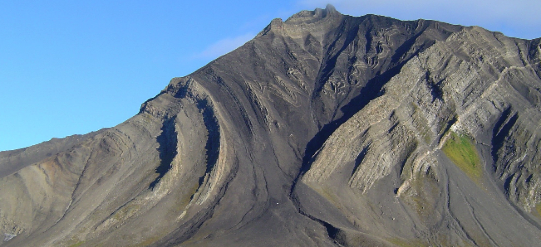 The strong variability in the structural style (geometry of folds, fault patterns etc) of syn-rift basins and inverted basins is due, in large part, to the rheological contrasts that can exist between evaporites, shales, sandstones, limestones and volcanics. The inversion, via forward modelling, of the structural style imaged through seismic methods, can help constrain the mechanical stratigraphy which, at the scale of sedimentary basin, control the structural style. This project aims at defining, via a simple inversion protocol, the mechanical stratigraphy of major sedimentary sub-basins along Australia’s North West Shelf and PNG. The project will straddle the Basin Genesis Hub Technology, Northwest Shelf and PNG research streams.
Image: Ólafur Lngólfsson
Formation of flat mountain tops: numerical simulation based on natural examples, implications for mountain erosion and sediment dispersal.
Supervisors: Tristan Salles, Gilles Brocard
Since the initial work from Davies (1899), peneplains and related features termed low-relief surfaces or paleosurfaces have been described on every continent and in many mountain belts around the world. However the preservation of these remarkable features atop uplifting mountains remains unclear. The rules most commonly used in numerical simulations of mountain erosion predict that such surfaces should quickly disappear. Therefore they challenge the general validity of the rules used to simulate mountain erosion and sediment dispersal. Here we propose to adapt the numerical model Badlands in order to incorporate the influence of the ‘tool effect’ (amount of bedload transported) and test whether it better captures mountain erosion. Being able to simulate their preservation is important in understanding fluvial processes, as well as accurately quantifying mountain erosion and sediment transport from source to sink.
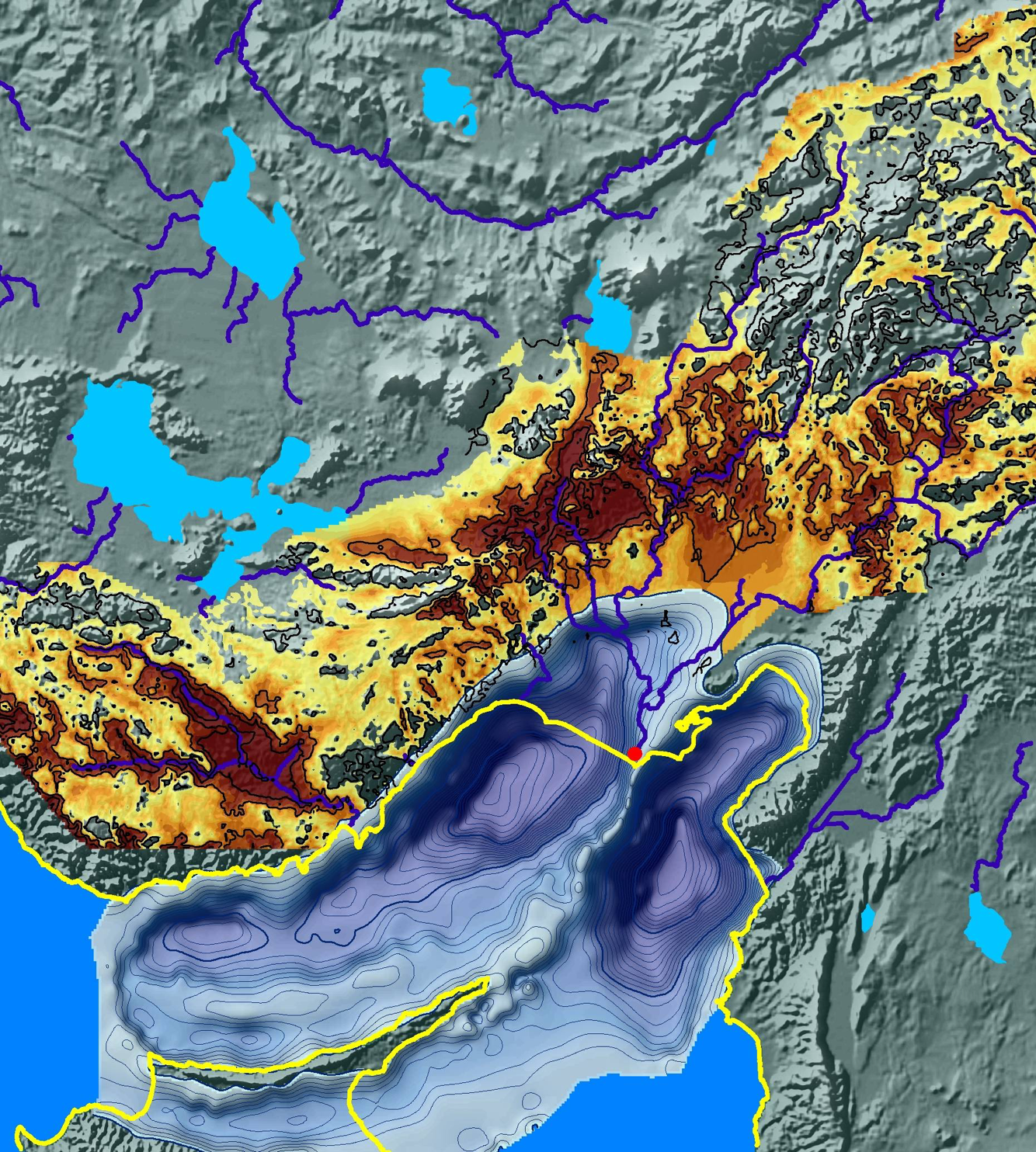
In this project, you will first define from obtained field observations (Puerto Rico, Guatemala, New Guinea) the geomorphological characteristics of perched planation surfaces. You will then estimate local and catchment-wide erosion rates by extrapolating field measurements of catchment-wide erosion in order to quantify landscape evolution. Finally, you will try to reproduce the stability of these geomorphic elements under different climatic and tectonic conditions using the numerical model, and propose scenarios of landscape dynamics on a wide range of scales (from individual catchment to basin-wide models).
The project will develop skills and experience in field data analysis, 3D visualisation and landscape evolution modelling, and be part of the Basin Genesis Hub Technology research stream.
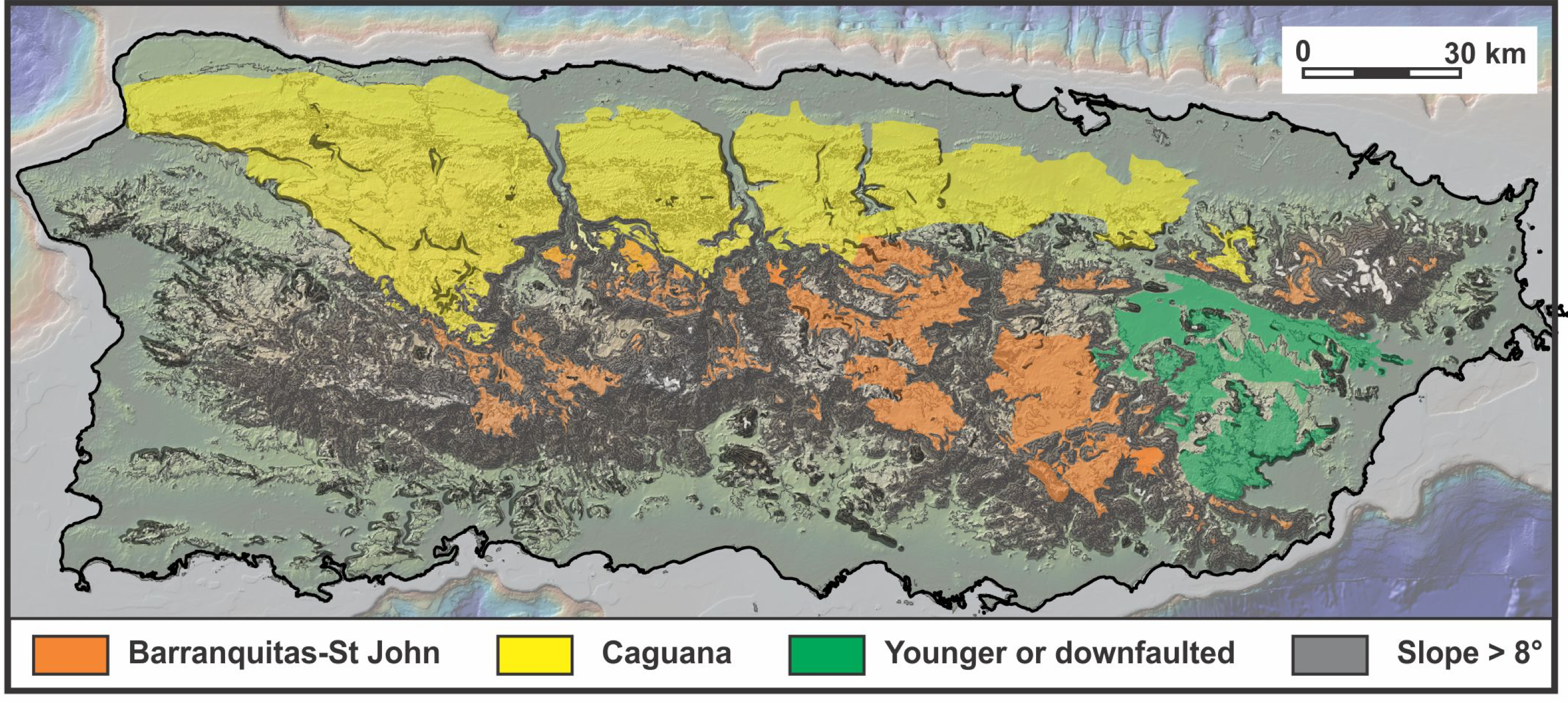
Image: Map of perched peneplains over the mountains of Puerto Rico
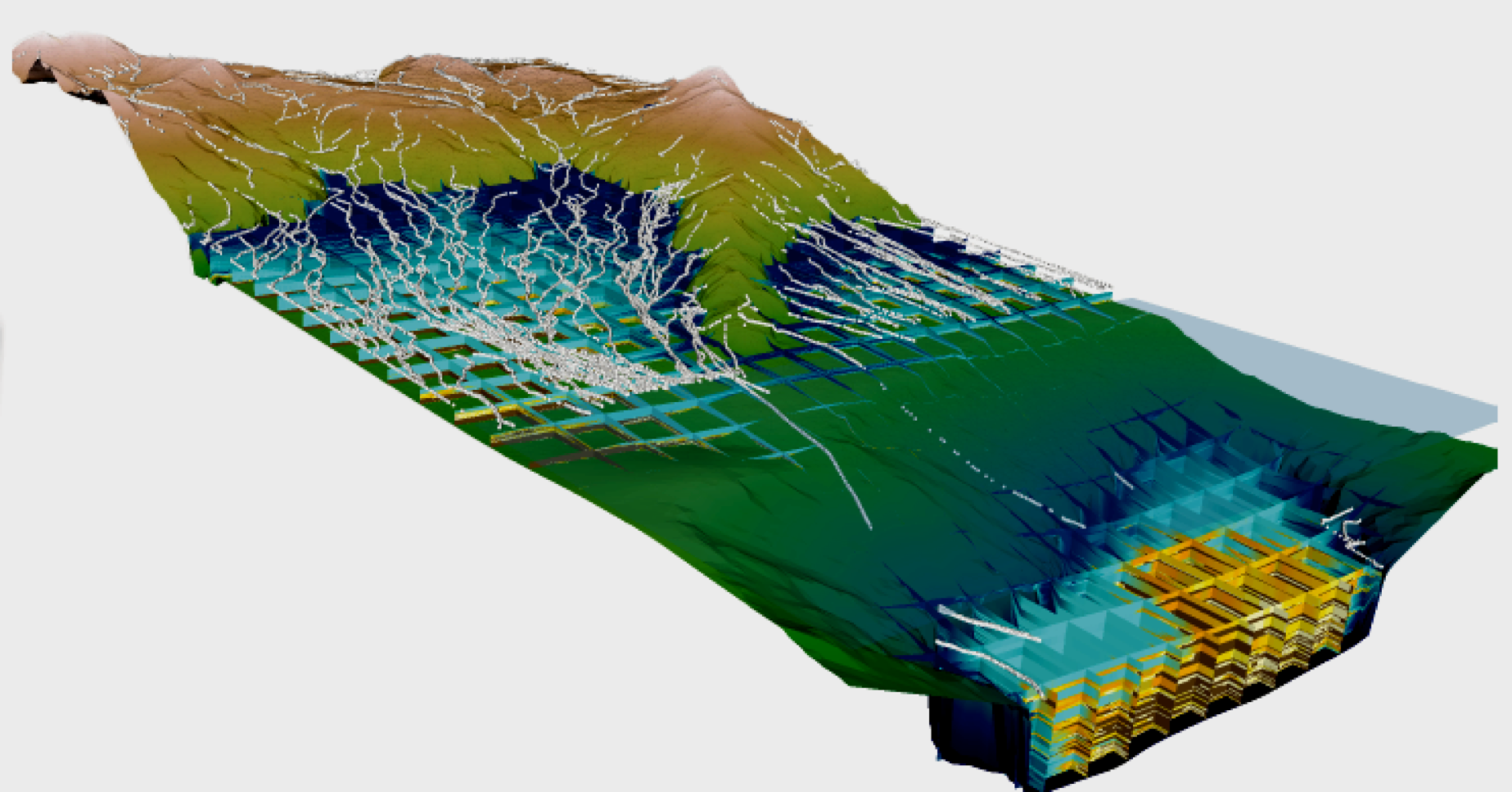
Formation of river knickpoints on growing anticlines: numerical simulation based on natural examples, implications for mountain erosion and sediment dispersal.
Supervisors: Gilles Brocard, Tristan Salles
 Migrating waves of incision, propagating upstream along river networks, represent an important process of erosion and landscape rejuvenation in many mountain ranges. Their formation has been related to fall in sea-level and accelerating mountain uplift. They typically initiate at breaks in slope in the river long profiles, either at the ledge of exposed continental margins, or farther inland where rivers cross active faults. From there, they propagate upstream. However, knickpoint generation and migration is also observed in areas of more diffuse tectonic deformation, a process which is presently poorly reproduced by numerical models. Being able to simulate their formation is important in understanding fluvial processes, as well as accurately quantifying mountain erosion and sediment transport from source to sink.
 In this project, you will first define from obtained field observations (Turkey, Huon Peninsula, New Guinea) the geomorphological characteristics of the drainage network. You will then estimate local and catchment-wide erosion rates by extrapolating field measurements of catchment-wide erosion in order to quantify landscape evolution. Finally, you will try to reproduce the formation and upstream migration under different climatic and tectonic conditions using the numerical model (Badlands), and propose scenarios of landscape dynamics on a wide range of scales (from individual catchment to basin-wide models).
The project will develop skills and experience in field data analysis, 3D visualisation and landscape evolution modelling, and be part of the Basin Genesis Hub Technology research stream.
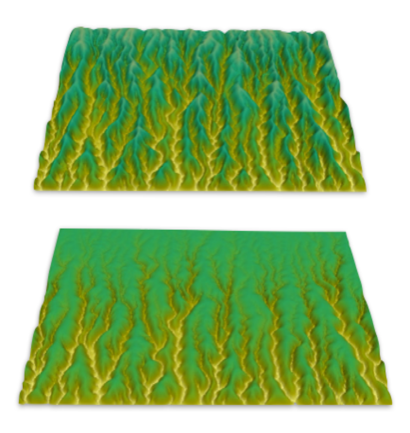
Image 1: Natural example of erosion of the southern margin of the Turkish plateau and sediment sink in the Mediterranean Sea
Image 2: Simulation of erosion along a plateau margin by headward migrating knickpoints through a simple arch (Badlands numerical model)
Exploring solid Earth models with machine learning
Supervisors: Simon Williams, Patrice Rey, Louis Moresi (Melb Uni)
Exploration for buried resources is driven by the acquisition of geological and geophysical data (boreholes, seismic, gravity, magnetics) that allow us to image the subsurface, and by geodynamic simulations that provide insights into how the subsurface is shaped by tectonic processes. Modern advances in computing and data storage give us access to huge volumes of both observational data and simulation output, providing an unprecedented opportunity to explore the relationship between the nature of structures (e.g. faulting and folding, uplift and subsidence due to mantle flow) imaged in actual data sets, and the patterns of deformation predicted by alternative simulations. This opportunity also presents new problems – how to make sense of these huge data volumes, and how to isolate the key parameters that can successfully link observations and simulations.
This project will aim to develop new approaches to the exploration of geodynamic simulations; generating synthetic geophysical data volumes from simulation output, and creating innovative techniques to allow quantitative comparisons between simulations and observations. The project may tackle a range of scales, from global mantle convection simulations to models of individual rift basins. The project will develop skills and experience in state-of-the-art computational tools for geophysical and geodynamic data analysis and machine learning. The project will be part of the Basin Genesis Hub Technology research stream.
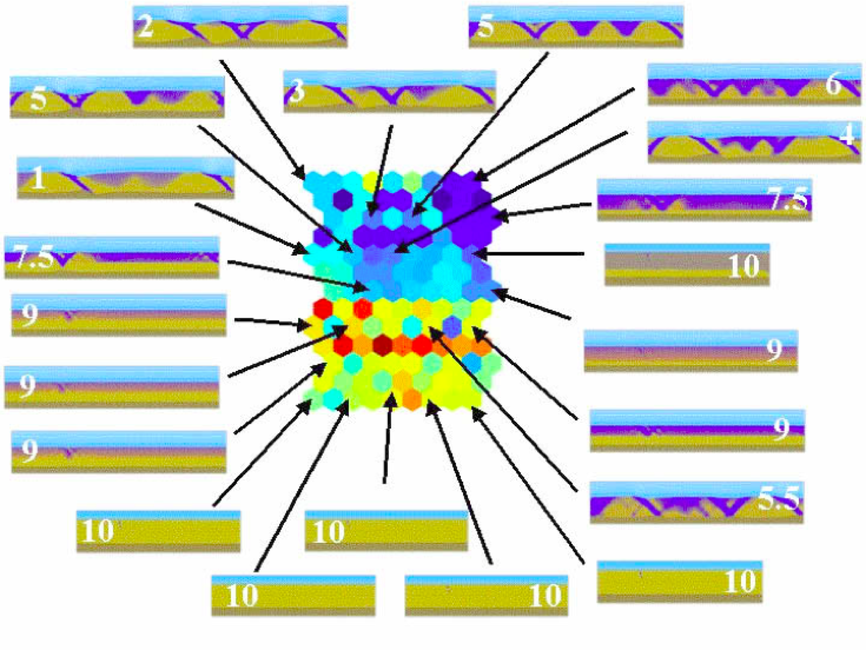
Image: 2D projection of lithospheric extension model parameter space as a self-organized map (Boschetti, Wijns and Moresi, G-cubed, 2003). Colour indicates distance between nodes in the map.
Feedback between lithospheric extension, surface processes, and climatic forcing
Supervisors: Patrice Rey, Tristan Salles
 This project investigates the interplay between extensional tectonics, and mass transfer at the Earth’s surface through erosion, sediment transportation and deposition. The weight of sediments has an important amplification effect on the surface subsidence, while in the meantime modulating the Moho upwarping during extension. This loading impacts also on the evolving deviatoric stress field, and therefore the tectonic evolution of basins. Sediments – which commonly have a low thermal conductivity – have also an important effect on the long term thermal structure and therefore rheology of the underlying lithosphere, and its response to deviatoric stresses. The rate of accumulation is also key to the burial of organic matter, and evolution of good source rocks. Being able to map through time the optimum accumulation rate in an evolving basin is therefore important. The project will be part of the Basin Genesis Hub Technology research stream.
Continental rifting, mantle melting and hyper-extended continental crust
Supervisors: Patrice Rey
The formation of continental margins through the processes of continental rifting often leads to strong vertical strain partitioning during which, the upper crust, the lower crust and the lithospheric mantle record contrasting style of extension. Because these layers have contrasting densities and thermal properties, vertical strain partitioning can lead to contrasting subsidence patterns and thermal evolutions. In addition, contrasting style of extension in the lithospheric mantle could explain the development of magmatic and a-magmatic continental margins. This project will specifically investigate the role of the mantle and mantle processes, including edge-driven mantle convection, in the evolution of continental margins. The project will be part of the Basin Genesis Hub Technology research stream.
![]()
