 Recently, EarthByte joined the Australia-China Joint Research Centre for Tectonics and Earth Resources (ACTER). The joint research centre is led by the Institute for Geoscience Research at Curtin University and the Institute of Geology and Geophysics of the Chinese Academy of Sciences, with involvement of Australian and Chinese universities and industry partners. The aim of the centre is to promote joint research activities, the exchange of staff and students, and to foster long-term mutually-beneficial collaboration between Australian and Chinese research groups. … Read more…
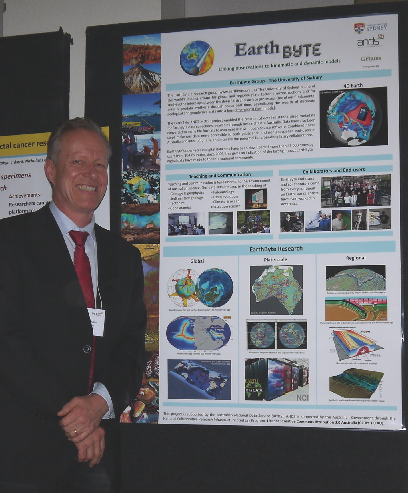
Prof Dietmar Müller
 Group Coordinator
Phone: +61 2 9351 4255
Fax: +61 2 9351 3644
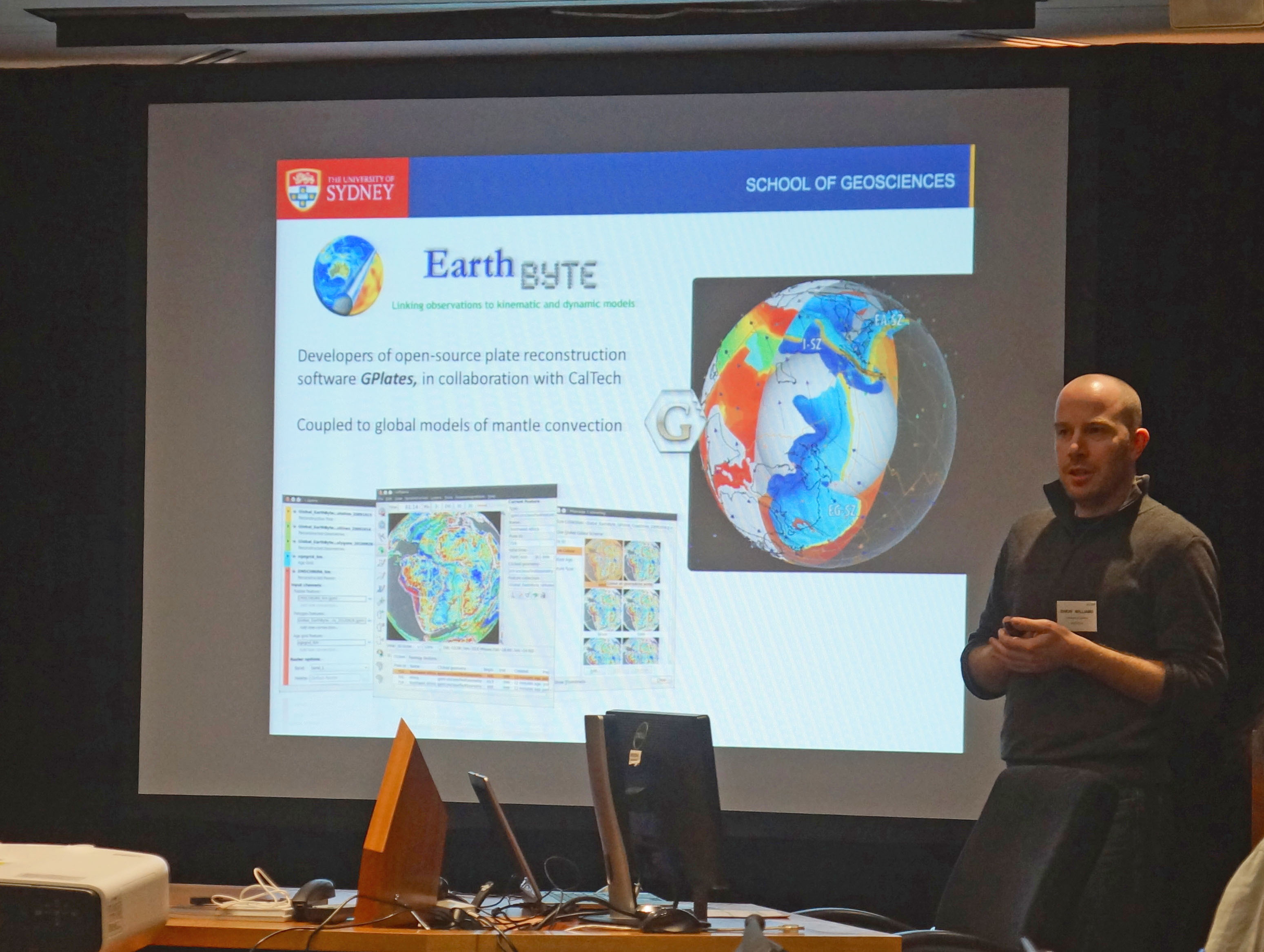
School of Geosciences
The University of Sydney
Sydney, NSW 2006
Australia
View Dietmar's Sydney Uni page
See below for EarthByte content related to Dietmar.

Geochemistry, Geophysics, Geosystems – Semi-automatic fracture zone tracking
Wessel, P., Matthews, K. J., Müller, R. D., Mazzoni, A., Whittaker, J. M., Myhill, R., & Chandler, M. T. (2015). Semi-automatic fracture zone tracking. Geochemistry, Geophysics, Geosystems. doi: 10.1002/2015GC005853. Semi-automatic fracture zone tracking This paper includes an update to the global seafloor tectonic fabric data set by Matthews et al. (JGR, 2011). Based on the vertical gravity … Read more…
Dietmar Müller attends Australian open research data showcase in Canberra
 Today Prof Dietmar Müller attended the Australian open research data showcase in Canberra. The showcase featured a variety of talks and discussions around the benefits and issues concerning open research data. It was an important milestone towards consolidating the Australian effort towards involving Universities and individual researchers in sharing their data.
A highlight was Ian Chubb’s presentation that pointed out that if you look at all papers published in the last 115 years, about 50% were either never cited or only cited once. The hope is that open access publications and associated open research data will improve these sorts of statistics. George Bernard Shaw was quoted by geologist Geoffrey Boulton (Univ. Edinburgh) as pointing out: “If you have an apple and I have an apple and we exchange these apples then you and I will still each have one apple. … Read more…
Reconstructed topography of Australia
Citation Heine, C., Müller, R. D., Steinberger, B. and DiCaprio, L., 2010, Integrating deep Earth dynamics in paleogeographic reconstructions of Australia, Tectonophysics, 483, 135-150. View other EarthByte animations on our YouTube channel
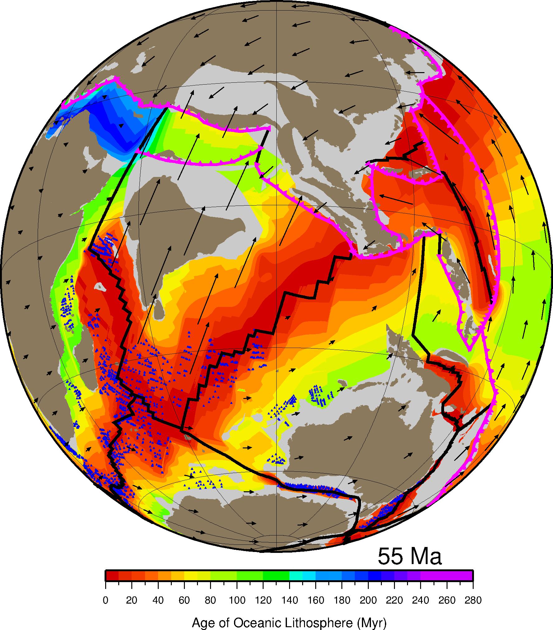
Plate reconstruction with paleo-bathymetry of the ocean basins
Reconstructions of tectonic plates and oceanic paleodepth (i.e. paleobathymetry).Citation Müller, R., M. Sdrolias, C. Gaina, and W. Roest (2008). Age, spreading rates, and spreading asymmetry of the world’s ocean crust, Geochemistry, Geophysics, Geosystems, 9(4), 19, Q04006. doi: 10.1029/2007GC001743.View the full playlist on our EarthByte YouTube channel
Geodynamics of arc-continent collisions
Courtesy of Prof Louis Moresi, created with the ellipsis software.Citation O’Neill, C., Moresi, L., Müller, R.D., Albert, R. and Dufour, F., 2006, Ellipsis 3D: a particle-in-cell finite element hybrid code for modelling mantle convection and lithospheric deformation, Computers and Geosciences, 32, 1769-1779.View other EarthByte animations on our YouTube channel
Dynamic topography of eastern Australia in the Cretaceous
Citation Gurnis, M., R. D. Müller, and L. Moresi (1998), Cretaceous vertical motion of Australia and the Australian Antarctic discordance, Science, 279(5356), 1499-1504.View other EarthByte animations on our YouTube channel
Mantle plumes in global convection models
Citation Hassan, R., N. Flament, M. Gurnis, D. J. Bower, and D. Müller (2015), Provenance of plumes in global convection models, Geochemistry, Geophysics, Geosystems.View other EarthByte animations on our YouTube channel
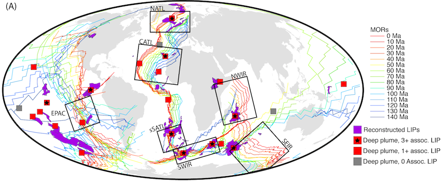
Nature Geoscience – Long-term interaction between mid-ocean ridges and mantle plumes

Whittaker, J. M., Afonso, J. C., Masterton, S., Müller, R. D., Wessel, P., Williams, S. E., & Seton, M. (2015). Long-term interaction between mid-ocean ridges and mantle plumes. Nature Geoscience, 8(6), 479-483. doi: http://dx.doi.org/10.1038/ngeo2437. Summary Plate tectonic motions are commonly considered to be driven by slab pull at subduction zones and ridge push at mid-ocean … Read more…
Long-term interaction between mid-ocean ridges and mantle plumes
 Citation
Whittaker, J. M., Afonso, J. C., Masterton, S., Müller, R. D., Wessel, P., Williams, S. E., & Seton, M. (2015). Long-term interaction between mid-ocean ridges and mantle plumes. Nature Geoscience, 8(6), 479-483.
Summary
Plate tectonic motions are commonly considered to be driven by slab pull at subduction zones and ridge push at mid-ocean ridges, with motion punctuated by plumes of hot material rising from the lower mantle. Within this model, the geometry and location of mid-ocean ridges are considered to be independent of lower-mantle dynamics, such as deeply sourced plumes that produce voluminous lava eruptions-termed large igneous provinces. Here we use a global plate model to reconstruct the locations of large igneous provinces relative to plumes and mid-ocean ridges at the time they formed. … Read more…
Geochemisty, Geophysics, Geosystems – Provenance of plumes in mantle convection models
Hassan, R., Flament, N., Gurnis, M., Bower, D. J., & Müller, D. (2015). Provenance of plumes in global convection models. Geochemistry, Geophysics, Geosystems. doi: 10.1002/2015GC005751. Provenance of plumes in global convection models
Geophysical Journal International – Absolute motion of Africa around Hawaii-Emperor bend time
Maher, S. M., Wessel, P., Müller, R. D., Williams, S. E., & Harada, Y. (2015). Absolute plate motion of Africa around Hawaii-Emperor bend time. Geophysical Journal International, 201(3), 1743-1764. doi: 10.1093/gji/ggv104. Absolute plate motion of Africa around Hawaii-Emperor bend time Download supplementary materials – zip file
Nature Geoscience – Deformation-related volcanism in the Pacific Ocean linked to the Hawaiin-Emperor bend
O’Connor, J. M., Hoernle, K., Müller, R. D., Morgan, J. P., Butterworth, N. P., Hauff, F., … & Stoffers, P. (2015). Deformation-related volcanism in the Pacific Ocean linked to the Hawaiian-Emperor bend. Nature Geoscience, 8(5), 393-397. doi: 10.1038/NGEO2416. Deformation-related volcanism in the Pacific Ocean linked to the Hawaiian–Emperor bend
GPlates course taught at EGU conference in Vienna
Prof Dietmar Müller, Dr Maria Seton and Dr Grace Shephard taught a GPlates course today at the European Geosciences Union (EGU) General Assembly in Vienna. The course was entitled ‘GPlates – make your own plate-tectonic reconstructions’.
Lord Howe Rise IODP workshop held at University of Sydney
Date: 2015 April 7-10 Venue: The University of Sydney Description: A science meeting at the University of Sydney was held to discuss details of the seven science themes in the Geoscience Australia (GA) – Japan Agency for Marine-Earth Science and Technology (JAMSTEC) initiated Lord Howe Rise IODP Pre-proposal, IODP proposal 871-Pre. The purpose of the meeting was to look … Read more…
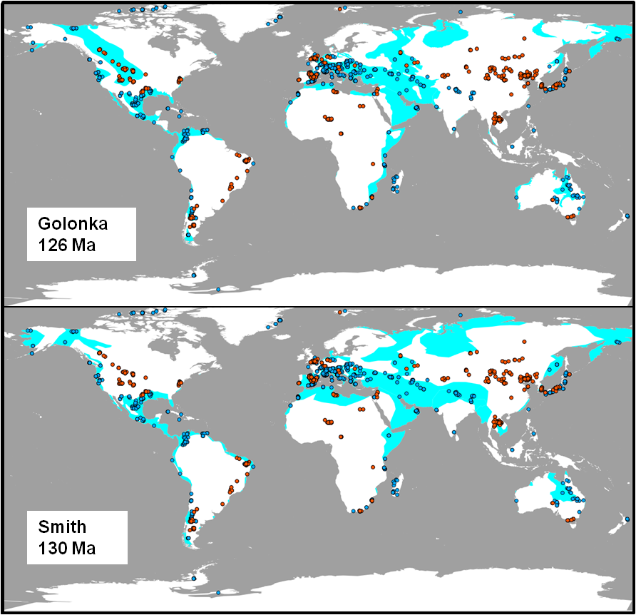
Evaluating global paleoshoreline models for the Cretaceous and Cenozoic
 Citation
Heine, C., Yeo, L. G., & Müller, R. D. (2015). Evaluating global paleoshoreline models for the Cretaceous and Cenozoic. Australian Journal of Earth Sciences, (ahead-of-print), 1-13., doi: 10.1080/08120099.2015.1018321.
Summary
Paleoshoreline maps represent the distribution of land and sea through geologic time. These compilations provide excellent proxies for evaluating the contributions non-tectonic vertical crustal motions, such as mantle convection-driven dynamic topography, to the flooding histories of continental platforms. Until now, such data have not been available as a globally coherent compilation. Here, we present and evaluate a set of Cretaceous and Cenozoic global shoreline data extracted from two independent published global paleogeographic atlases. … Read more…
Tectonic speed limits from plate kinematic reconstructions
 Citation
Zahirovic, S., Müller, R. D., Seton, M., & Flament, N. (2015). Tectonic speed limits from plate kinematic reconstructions. Earth and Planetary Science Letters, 418, 40-52. doi:10.1016/j.epsl.2015.02.037.
Summary
The motion of plates and continents on the planet’s surface are a manifestation of long-term mantle convection and plate tectonics. Present-day plate velocities provide a snapshot of this ongoing process, and have been used to infer controlling factors on the speeds of plates and continents. However, present-day velocities do not capture plate behaviour over geologically representative periods of time. To address this shortcoming, we use a plate tectonic reconstruction approach to extract time-dependent plate velocities and geometries from which root mean square (RMS) velocities are computed, resulting in a median RMS plate speed of ~4 cm/yr over 200 Myr. … Read more…
ScienceNews features an article on Pacific plate motions paper
EarthByte paper ‘Revision of Paleogene plate motions in the Pacific and implications for the Hawaiian-Emperor bend‘ is featured in ScienceNews with an article entitled ‘Plate loss gave chain of Pacific islands and seamounts a bend‘. Revision of Paleogene plate motions in the Pacific and implications for the Hawaiian-Emperor bend
Global plate and continental velocities since Pangea breakup
This animation portrays the motion of continents (grey, yellow, orange and red) and oceanic plates (blue) since Pangea breakup from 200 million years ago. The model is a modified version of the Seton et al.Citation Zahirovic, S., R. Müller, M. Seton, and N. Flament (2015), Tectonic speed limits from plate kinematic reconstructions, Earth and Planetary … Read more…
Geophysical Research Letters – Ridge subduction sparked reorganisation of the Pacific plate-mantle system 60-50 million years ago
Seton, M., Flament, N., Whittaker, J., Müller, R. D., Gurnis, M., & Bower, D. J. (2015). Ridge subduction sparked reorganization of the Pacific plate‐mantle system 60–50 million years ago. Geophysical Research Letters, 42(6), 1732-1740. doi: 10.1002/2015GL063057. Ridge subduction sparked reorganization of the Pacific plate‐mantle system 60–50 million years ago
A tectonic model reconciling evidence for the collisions between India, Eurasia and intra-oceanic arcs of the central-eastern Tethys
 Citation
Gibbons, A., Zahirovic, S., Muller, R.D., Whittaker, J., and Yatheesh, V. 2015. A tectonic model reconciling evidence for the collisions between India, Eurasia and intra-oceanic arcs of the central-eastern Tethys. Gondwana Research FOCUS, doi: 10.1016/j.gr.2015.01.001.
Summary
Despite several decades of investigations, inferences on the timing and nature of collisions along the Mesozoic–Cenozoic Eurasian margin remain controversial. We assimilate geological and geophysical evidence into a plate tectonic model for the India–Eurasia collision that includes continuously– … Read more…
Ore Geology Reviews – Prospectivity of Western Australian iron ore from geophysical data using a reject option classifier
Merdith, A. S., Landgrebe, T. C., & Müller, R. D. (2015). Prospectivity of Western Australian iron ore from geophysical data using a reject option classifier. Ore Geology Reviews. doi: 10.1016/j.oregeorev.2015.03.014. Prospectivity of Western Australian iron ore from geophysical data using a reject option classifier
Geology – Revision of Paleogene plate motions in the Pacific and implications for the Hawaiian-Emperor bend
Wright, N. M., Müller, R. D., Seton, M., & Williams, S. E. (2015). Revision of Paleogene plate motions in the Pacific and implications for the Hawaiian-Emperor bend. Geology, 43(5), 455-458. doi: 10.1130/G36303.1. Revision of Paleogene plate motions in the Pacific and implications for the Hawaiian-Emperor bend
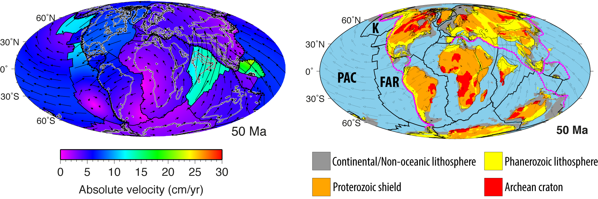
Earth and Planetary Science Reviews – Absolute plate motions since 130 ma constrained by subduction zone kinematics
Williams, S., Flament, N., Müller, R. D., & Butterworth, N. (2015). Absolute plate motions since 130 Ma constrained by subduction zone kinematics. Earth and Planetary Science Letters, 418, 66-77. doi:10.1016/j.epsl.2015.02.026. Absolute plate motions since 130 Ma constrained by subduction zone kinematics
Age, spreading rates and spreading asymmetry of the world’s ocean crust
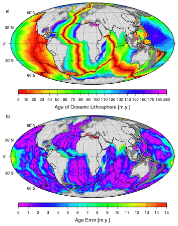
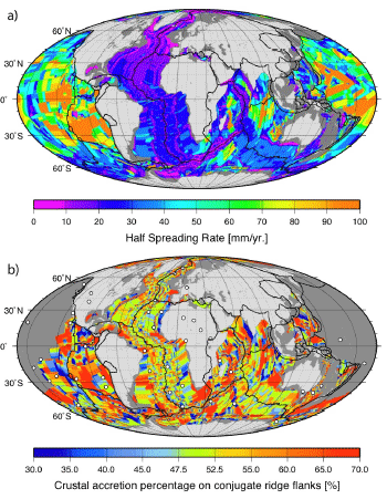 We present four companion digital models of the age, age uncertainty, spreading rates and spreading asymmetries of the world’s ocean basins as geographic and Mercator grids with 2 minute resolution. The grids include data from all the major ocean basins as well as detailed reconstructions of back-arc basins.
The age, spreading rate and asymmetry at each grid node is determined by linear interpolation between adjacent seafloor isochrons in the direction of spreading. Ages for ocean floor between the oldest identified magnetic anomalies and continental crust are interpolated by geological estimates of the ages of passive continental margin segments. … Read more…
Supplementary resources for “Absolute plate motions since 130 Ma constrained by subduction zone kinematics”
 Citation
Williams, S., Flament, N., Müller, R. D., & Butterworth, N. (2015). Absolute plate motions since 130 Ma constrained by subduction zone kinematics. Earth and Planetary Science Letters, 418, 66-77. doi:10.1016/j.epsl.2015.02.026.
Summary
The supplementary data set comprise plate reconstructions from 130 Ma to present-day, designed to be used within the open-source reconstruction software GPlates.
There are eight sets of reconstructions. In each case, the relative plate motion (RPM) model is unchanged; the differences lie in the absolute plate motion (APM) model. This is expressed in the rotation file as the finite poles of rotation that describe motion of Africa relative to the Earth’s spin-axis. These files were the basis of the results presented in the EPSL paper. … Read more…
Supplementary resources for "Absolute plate motions since 130 Ma constrained by subduction zone kinematics"
Citation
Williams, S., Flament, N., Müller, R. D., & Butterworth, N. (2015). Absolute plate motions since 130 Ma constrained by subduction zone kinematics. Earth and Planetary Science Letters, 418, 66-77. doi:10.1016/j.epsl.2015.02.026.
Summary
The supplementary data set comprise plate reconstructions from 130 Ma to present-day, designed to be used within the open-source reconstruction software GPlates.
There are eight sets of reconstructions. In each case, the relative plate motion (RPM) model is unchanged; the differences lie in the absolute plate motion (APM) model. This is expressed in the rotation file as the finite poles of rotation that describe motion of Africa relative to the Earth’s spin-axis. These files were the basis of the results presented in the EPSL paper. … Read more…
Earth and Planetary Science Letters – Tectonic speed limits from plate kinematic reconstructions
Zahirovic, S., Müller, R. D., Seton, M., & Flament, N. (2015). Tectonic speed limits from plate kinematic reconstructions. Earth and Planetary Science Letters, 418, 40-52. doi: 10.1016/j.epsl.2015.02.037. Tectonic speed limits from plate kinematic reconstructions
Australian Journal of Earth Sciences – Evaluating global paleoshoreline models for the Cretaceous and Cenozoic
Heine, C., Yeo, L. G., & Müller, R. D. (2015). Evaluating global paleoshoreline models for the Cretaceous and Cenozoic. Australian Journal of Earth Sciences, (ahead-of-print), 1-13. Evaluating global paleoshoreline models for the Cretaceous and Cenozoic Download the Paleocoastline files – zip file
EarthByte welcomes Wenchao Cao
Welcome to Wenchao Cao who has started a PhD with the EarthByte group this month! Wenchao completed a BSc and MSc in geology at China University of Geosciences in Wuhan and will be working with Dietmar, Nico and Sabin.