Computer vision-based framework for extracting tectonic lineaments from optical remote sensing data

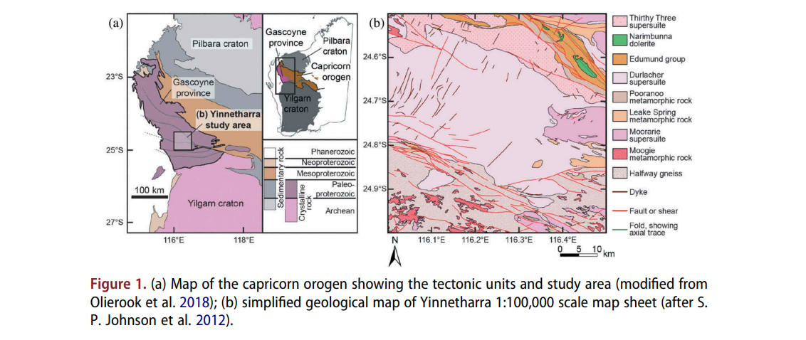
Abstract: The extraction of tectonic lineaments from digital satellite data is a fundamental application in remote sensing. The location of tectonic lineaments such as faults and dykes are of interest for a range of applications, particularly because of their association with hydrothermal mineralization. Although a wide range of applications have utilized computer vision techniques, a … Read more…

The interplay of dynamic topography and eustasy on continental flooding in the late Paleozoic

Abstract: Global sea level change can be inferred from sequence stratigraphic and continental flooding data. These methods reconstruct sea level from peri-cratonic and cratonic basins that are assumed to be tectonically stable and sometimes called reference districts, and from spatio-temporal correlations across basins. However, it has been understood that long-wavelength (typically hundreds of km) and low-amplitude … Read more…

Constraining Absolute Plate Motions Since the Triassic

Abstract: The absolute motion of tectonic plates since Pangea can be derived from observations of hotspot trails, paleomagnetism, or seismic tomography. However, fitting observations is typically carried out in isolation without consideration for the fit to unused data or whether the resulting plate motions are geodynamically plausible. Through the joint evaluation of global hotspot track … Read more…

Bayeslands: A Bayesian inference approach for parameter uncertainty quantification in Badlands

Abstract: Bayesian inference provides a rigorous methodology for estimation and uncertainty quantification of unknown parameters in geophysical forward models. Badlands is a landscape evolution model that simulates topography development at various space and time scales. Badlands consists of a number of geophysical parameters that needs estimation with appropriate uncertainty quantification; given the observed present-day ground truth … Read more…

Decoding earth’s plate tectonic history using sparse geochemical data

Abstract: Accurately mapping plate boundary types and locations through time is essential for understanding the evolution of the plate-mantle system and the exchange of material between the solid Earth and surface environments. However, the complexity of the Earth system and the cryptic nature of the geological record make it difficult to discriminate tectonic environments through … Read more…

Modeling geochemical anomalies of stream sediment data through a weighted drainage catchment basin method for detecting porphyry Cu-Au mineralization

Abstract: Stream sediment surveying is a geochemical sampling method which is typically applied in the preliminary stages of mineral prospecting. Both continuous and discrete mapping approaches have been proposed to delineate geochemical anomalies at large scales using stream sediment samples. We aim to enhance the efficiency of a recent discrete mapping method called Weighted Drainage … Read more…

Tectonic, geodynamic and surface process driving forces of Australia’s paleogeography since the Jurassic

Abstract: Today the eastern highlands of Australia are significantly more elevated than western Australia, but the continent’s geodynamic evolution suggests that the opposite was the case during Cretaceous times, when the Eromanga Sea dominated the eastern Australian landscape. Previous geodynamic and surface processes models have been used to simulate the evolution of this seaway, but … Read more…

Deep Carbon Cycling Over the Past 200 Million Years: A Review of Fluxes in Different Tectonic Settings

Abstract: Carbon is a key control on the surface chemistry and climate of Earth. Significant volumes of carbon are input to the oceans and atmosphere from deep Earth in the form of degassed CO2 and are returned to large carbon reservoirs in the mantle via subduction or burial. Different tectonic settings (e.g., volcanic arcs, mid-ocean … Read more…

Muller et al. (2019) deforming plate reconstructions and associated digital supplements (Tectonics)

A Global Plate Model Including Lithospheric Deformation Along Major Rifts and Orogens Since the Triassic R. Dietmar Müller, Sabin Zahirovic, Simon E. Williams, John Cannon, Maria Seton, Dan J. Bower, Michael G. Tetley, Christian Heine, Eline Le Breton, Shaofeng Liu, Samuel H. J. Russell, Ting Yang, Jonathon Leonard, and Michael Gurnis Journal: Tectonics (open access) … Read more…

The interplay of dynamic topography and eustasy on continental flooding in the late Paleozoic

Abstract: Global sea level change can be inferred from sequence stratigraphic and continental flooding data. These methods reconstruct sea level from peri-cratonic and cratonic basins that are assumed to be tectonically stable and sometimes called reference districts, and from spatio-temporal correlations across basins. However, it has been understood that long-wavelength (typically hundreds of km) and … Read more…

Magma production along the Lord Howe Seamount Chain, northern Zealandia

Citation: Seton, M, Williams, S.E., Mortimer, N., Meffre, S., Micklethwaite, S., Zahirovic, S., 2019, Magma production along the Lord Howe Seamount Chain, northern Zealandia, Geological Magazine, 1-13, https://doi.org/10.1017/S0016756818000912 Abstract: One of the world’s most notable intraplate volcanic regions lies on the eastern Australian plate and includes two age-progressive trails offshore (Tasmantid and Lord Howe seamount chains) and the … Read more…

Rift and plate boundary evolution across two supercontinent cycles

Citation: Merdith, Andrew & Williams, Simon & Brune, Sascha & Collins Alan, S & Müller, Dietmar. (2018). Rift and plate boundary evolution across two supercontinent cycles. Global and Planetary Change. 173. 10.1016/j.gloplacha.2018.11.006. Abstract The extent of continental rifts and subduction zones through deep geological time provides insights into the mechanisms behind supercontinent cycles and the long term evolution of the mantle. … Read more…

Sequestration and subduction of deep-sea carbonate in the global ocean since the Early Cretaceous

Citation: Dutkiewicz, Adriana & Müller, Dietmar & Cannon, John & Vaughan, Sioned & Zahirovic, Sabin. (2018). Sequestration and subduction of deep-sea carbonate in the global ocean since the Early Cretaceous. Geology. 10.1130/G45424.1. Abstract Deep-sea carbonate represents Earth’s largest carbon sink and one of the least-known components of the long-term carbon cycle that is intimately linked … Read more…