Join us for a fascinating talk with Dr. Amando Lasabuda from University of Oslo and The University of Sydney. In this EarthByte Seminar Series event, Amando will talk about reconstructing the paleogeography of glaciated continental margins and their sediment source-to-sink systems with an example from the Barents Sea, Norwegian Arctic.
Seminar Details:
- Date: Wednesday, 21 February 2024
- Time: 11 am – 12 pm AEDT
- Location: Geoscience Conference Room 449 and online
- Zoom Link: https://uni-sydney.zoom.us/j/84898040605?from=addon
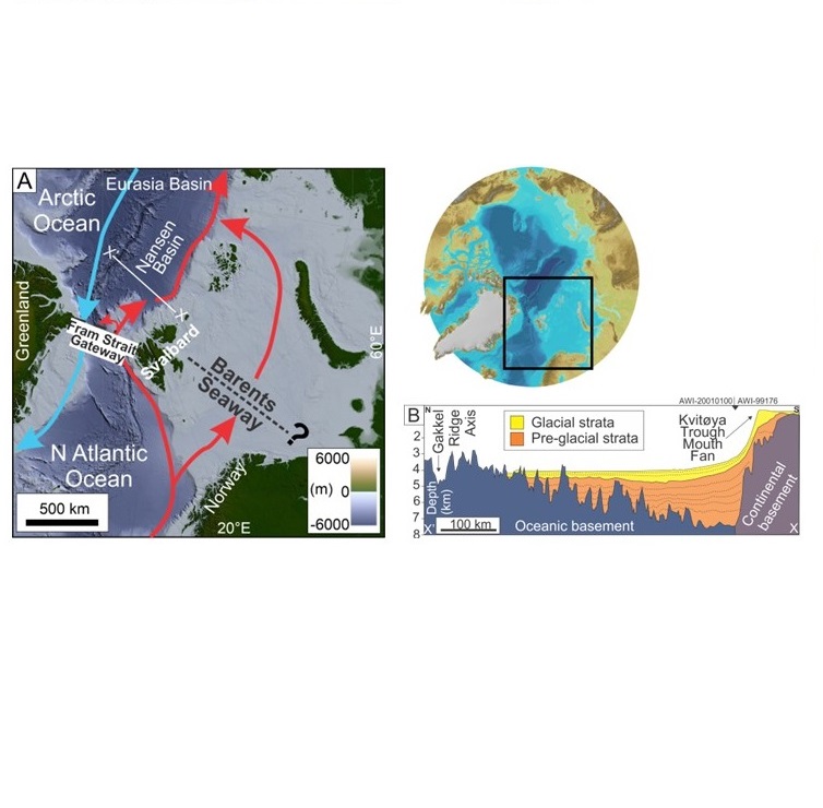
How do we reconstruct paleogeography of glaciated continental margins and their sediment source-to-sink systems? An example from the Barents Sea, Norwegian Arctic.
Reconstructing paleo-bathymetry and -topography of glaciated continental margins can be complicated due to uncertainty surrounding the volume of eroded sediment, lateral extent and thickness of ice sheet, and deeper mantle processes. This uncertainty has been a long-standing problem for the community where numerous oceanographic and climatic models have been built on less constrained paleogeography of formerly glaciated margins. Moreover, the corresponding sediment source-to-sink reconstructions are poorly understood when we put this into a global ocean circulation context. The Barents Seaway in the Norwegian Arctic is underexplored in terms of its opening history compared to the Fram Strait Gateway. The study area is a missing puzzle to understand when precisely the Atlantic water started to flow into the Arctic Ocean through this continental seaway. The Barents Sea is a frontier area but rich in subsurface data due to energy exploration, which can be used as a comparison to other polar basins, including Antarctica. Since the early Cenozoic (c. 55 Ma) and before the northern hemisphere glaciation (ca. 2.7 Ma), the Barents Sea continental margin has been subjected to complex tectonic events that led to the development of fold-and-thrust belt on Svalbard, pull-apart basin leading to volcanism and transtension on the western margin, and transform setting in its northern margin. I will discuss challenges in reconstructing the paleo-bathymetry and -topography in the Barents Sea and how we can combine a multi-proxy approach (e.g. seismic & well data) with numerical modelling.
![]()
