 Citation
Sandwell, D. T., Müller, R. D., Smith, W. H. F., Garcia, E. and Francis, R. 2014. New global marine gravity model from Cryo-Sat-2 and jason-1 reveals buried tectonic structure. Science, Vol. 346, 6205, pp. 65-67, doi: 10.1126/science.1258213.
Summary
New global marine gravity model from CryoSat-2 and Jason-1 reveals buried tectonic structure.
View the new gravity map in an online 3D portal!
Gravity models are powerful tools for mapping tectonic structures, especially in the deep ocean basins where the topography remains unmapped by ships or is buried by thick sediment. We combined new radar altimeter measurements from satellites CryoSat-2 and Jason-1 with existing data to construct a global marine gravity model that is two times more accurate than previous models. We found an extinct spreading ridge in the Gulf of Mexico, a major propagating rift in the South Atlantic Ocean, abyssal hill fabric on slow-spreading ridges, and thousands of previously uncharted seamounts. These discoveries allow us to understand regional tectonic processes and highlight the importance of satellite-derived gravity models as one of the primary tools for the investigation of remote ocean basins.
Downloads
Download the paper – pdf.
The research is discussed in a related paper in Science: Seafloor secrets revealed: Satellite data reveal formerly unknown tectonics structures.
 Figures
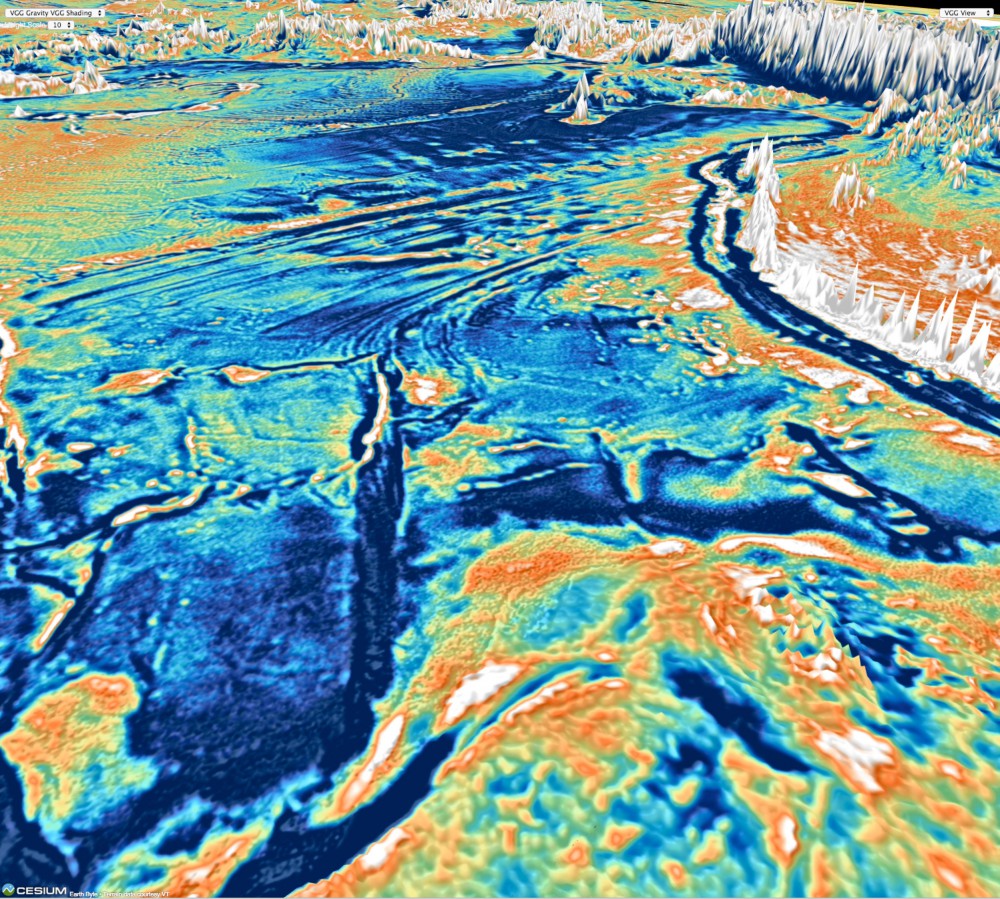
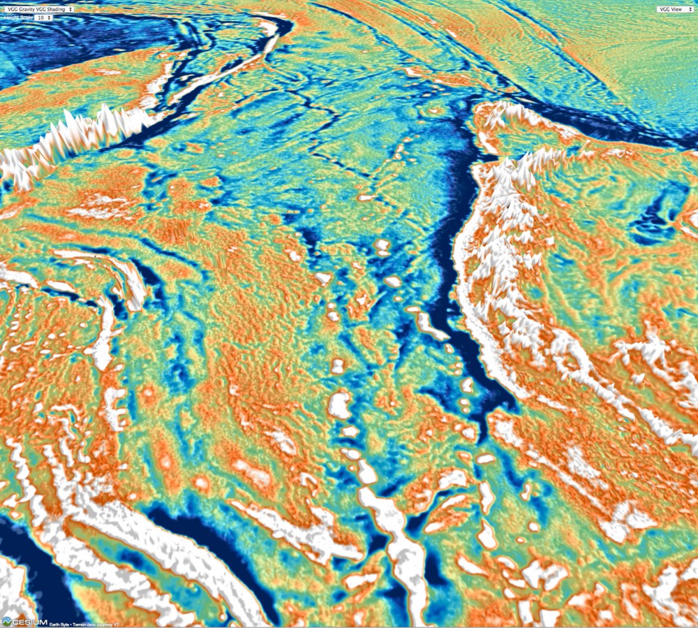
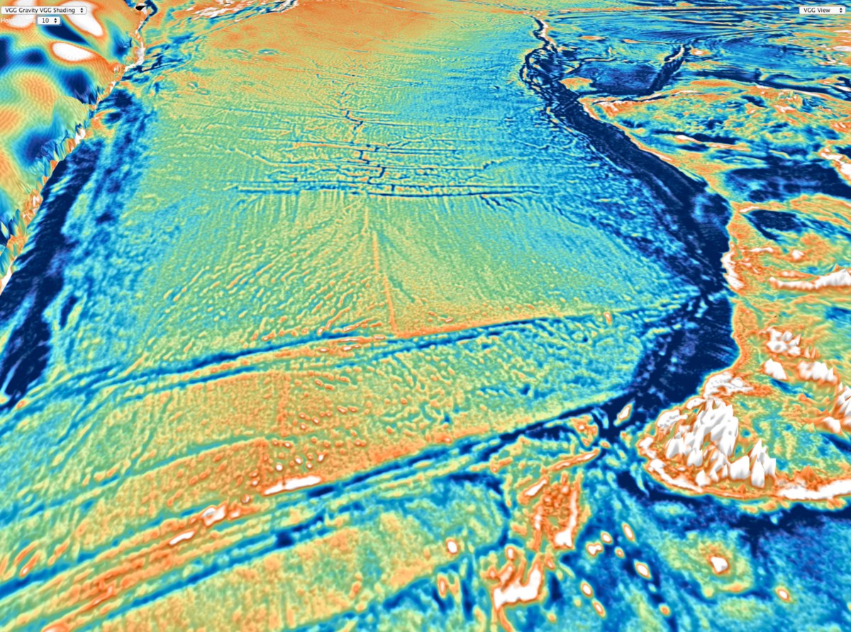
Top: The gravity field of the Indian Ocean west of Australia, based on the new satellite-derived gravity model. The view is towards the west. The map reveals the detailed fabric of oceanic fracture zones, abyssal hill fabric, seamounts, submerged microcontinents and ancient extinct spreading ridges. Bottom Left: The gravity field of the Tasman Sea and Lord Howe Rise east of Australia, based on the new satellite-derived gravity model. The view is towards the south. The map reveals the detailed fabric of oceanic fracture zones, abyssal hill fabric, seamounts, submerged microcontinents and ancient extinct spreading ridges. Bottom Right: The gravity field of the Indian Ocean south of Australia, based on the new satellite-derived gravity model. The view is towards the west. The map reveals the detailed fabric of oceanic fracture zones, so-called pseudo faults and extinct ridges, abyssal hill fabric, seamounts and submerged continental plateaus such as the South Tasman Rise.
Related Content
Press Release – Mapping the Seafloor from Space
CIO News Article
Spiegel Article
Business Insider Article
BBC News Article
The Daily Mail UK Article
Scripps Institute Article
The San Diego Union Tribune Article
South China Morning Post Article
Science Now Article
Science News Article
ABC News Article
PhysOrg Article
Txchnologist Blog
Project Website – Exploring Ocean Tectonics from Space
GPlates Portal Website
![]()
