 This update replaces the original Total Sediment Thickness of the World’s Oceans & Marginal Seas (Divins, 2003).
Citation
Whittaker, J. M., Goncharov, A., Williams, S. E., Müller, R. D., & Leitchenkov, G. (2013). Global sediment thickness data set updated for the Australian‐Antarctic Southern Ocean. Geochemistry, Geophysics, Geosystems, 14(8), 3297-3305. doi: 10.1002/ggge.20181.
Summary
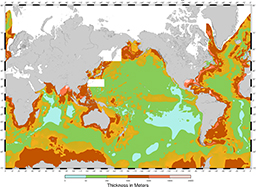
NGDC’s global ocean sediment thickness grid (Divins, 2003) has been updated for the Australian-Antarctic region (60°-155°E, 30°-70°S). New seismic reflection and refraction data have been used to add detail to the conjugate Australian and Antarctic margins and intervening ocean floor where previously regional sediment thickness patterns were poorly known.
On the margins, sediment thickness estimates were computed from velocity-depth functions from sonobuoy/refraction velocity solutions ground-truthed against seismic reflection data. For the Southeast Indian Ridge abyssal plain, sediment thickness contours from Géli et al. (2007) were used.
The new regional sediment thickness grid was combined with NGDC’s original ocean sediment thickness grid (Divins, 2003) to create an updated global grid of ocean sediment thickness. Even using the minimum estimates, sediment accumulations on the extended Australian and Antarctic continental margins are 2 km thicker across large regions and up to 9 km thicker in the Ceduna Basin compared to NGDC’s original sediment thickness grid (Divins, 2003), which has been deprecated but is still available.
Downloads
GMT NetCDF file (7 Mb)
XYZ file (21 Mb)
Geotiff (6 Mb)
ArcGIS file (6 Mb)
Other references
http://onlinelibrary.wiley.com/doi/10.1002/ggge.20181/abstract
Divins, D.L., Total Sediment Thickness of the World’s Oceans & Marginal Seas, NOAA National Geophysical Data Center, Boulder, CO, 2003. http://www.ngdc.noaa.gov/mgg/sedthick/sedthick.html
Géli, L., Cochran, J., Lee, T., Francheteau, J., Labails, C., Fouchet, C., and Christie, D., 2007, Thermal regime of the Southeast Indian Ridge between 88°E and 140°E: Remarks on the subsidence of the ridge flanks: J. Geophys. Res., v. 112, no. B10, p. B10101. http://onlinelibrary.wiley.com/doi/10.1029/2006JB004578/abstract
Divins, D.L., Thickness of Sedimentary Cover in the Eastern Pacific Ocean, in International Geological-Geophysical Atlas of the Pacific Ocean, edited by G.B. Udintsev, pp. 120, 126-127, 130, Intergovernmental Oceanographic Commission, Moscow-Saint Petersburg, 2003.
Divins, D.L., and P.D. Rabinowitz, Thickness of Sedimentary Cover for the South Atlantic, in International Geological-Geophysical Atlas of the Atlantic Ocean, edited by G.B. Udintsev, pp. 126-127, Intergovernmental Oceanographic Commission, Moscow, 1990.
Hayes, D.E., and J.L. LaBrecque, Sediment Isopachs: Circum-Antarctic to 30S, in Marine Geological and Geophysical Atlas of the Circum-Antarctic to 30S, edited by D.E. Hayes, pp. 29-33, American Geophys. Union, Washington, D.C., 1991.
Ludwig, W.J., and R.E. Houtz, Isopach Map of the Sediments in the Pacific Ocean Basin, color map with text, Am. Assoc. Pet. Geol., Tulsa, OK., 1979.
Matthias, P.K., P.D. Rabinowitz, and N. Dipiazza, Sediment Thickness map of the Indian Ocean, Map 505, Am. Assoc. Pet. Geol., Tulsa, OK., 1988.
Smith, W.H.F., and P. Wessel, Gridding with Continuous Curvature Splines in Tension, Geophysics, 55, 1990.
Tucholke, B.E., and E. Uchupi, Thickness of Sedimentary Cover for the North Atlantic, in International Geological-Geophysical Atlas of the Atlantic Ocean, edited by G.B. Udintsev, pp. 122-125, Intergovernmental Oceanographic Commission, Moscow, 1990.
Udinstev, G.B. (editor), International Geological-Geophysical Atlas of the Pacific Ocean, 192 p., Intergovernmental Oceanographic Commission, Moscow-Saint Petersburg, 2003.
![]()
