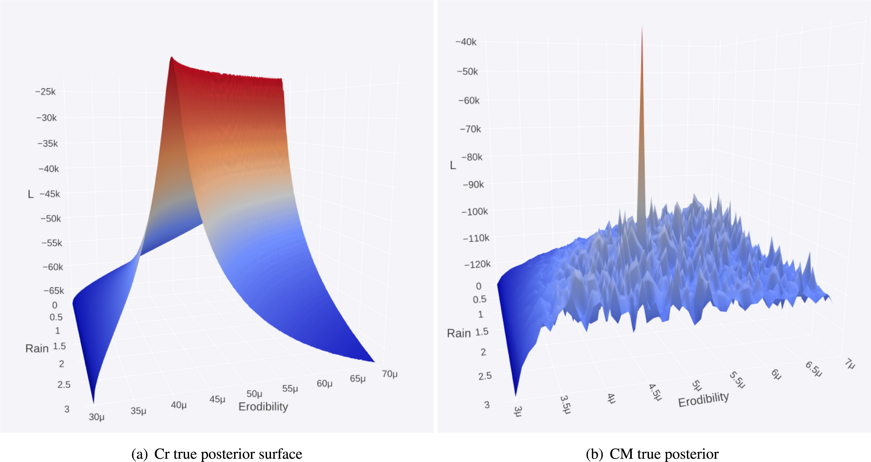
Communications Earth & Environment: Quaternary landscape dynamics boosted species dispersal across Southeast Asia

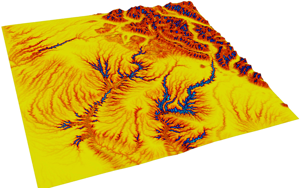
Sundaland, the inundated shelf separating Java, Sumatra and Borneo from the Malay Peninsula, is of exceptional interest to biogeographers for its species richness and its position at the junction between the Australasian and Indomalay biogeographic provinces. Owing to its low elevation and relief, its physiography is contingent on relative sea-level change, which drove Quaternary species … Read more…

Geosphere: Fast Pliocene integration of the Central Anatolian Plateau drainage: Evidence, processes, and driving forces

Continental sedimentation was widespread across the Central Anatolian Plateau in Miocene– Pliocene time, during the early stages of plateau uplift. Today, however, most sediment produced on the plateau is dispersed by a well-integrated drainage and released into surrounding marine depocenters. Residual long-term (106–107 yr) sediment storage on the plateau is now restricted to a few … Read more…

Basin Research: Modelling the role of dynamic topography and eustasy in the evolution of the Great Artesian Basin

Widespread flooding of the Australian continent during the Early Cretaceous, referred to as the Eromanga Sea, deposited extensive shallow marine sediments throughout the Great Artesian Basin (GAB). This event had been considered ‘out of sync’ with eustatic sea level and was instead solely attributed to dynamic subsidence associated with Australia’s passage over eastern Gondwanan subducted … Read more…

PhD Scholarship Opportunity for Domestic Australian Students

THE RISE AND DEMISE OF EARTH’S GIANT REEF SYSTEMS   Expression of Interest This PhD scholarship is only available to Australian domestic applicants. Submit your expression of interest for this PhD scholarship opportunity to Dr Sabin Zahirovic via email (sabin.zahirovic@sydney.edu.au) by 30 June 2021 (with the subject line “DECRA-PHD-2021”). In your expression of interest, include … Read more…

Paper in Frontiers of Earth Science: Modeling the Dynamic Landscape Evolution of a Volcanic Coastal Environment Under Future Climate Trajectories

Modeling the Dynamic Landscape Evolution of a Volcanic Coastal Environment Under Future Climate Trajectories Kyle Manley, T. Salles and R. D. Müller As anthropogenic forcing continues to rapidly modify worldwide climate, impacts on landscape changes will grow. Olivine weathering is a natural process that sequesters carbon out of the atmosphere, but is now being proposed … Read more…

Bayeslands: A Bayesian inference approach for parameter uncertainty quantification in Badlands

Abstract: Bayesian inference provides a rigorous methodology for estimation and uncertainty quantification of unknown parameters in geophysical forward models. Badlands is a landscape evolution model that simulates topography development at various space and time scales. Badlands consists of a number of geophysical parameters that needs estimation with appropriate uncertainty quantification; given the observed present-day ground truth … Read more…

AuScope reviews innovations of the ARC Basin Genesis HUB

Sedimentary basins around the world are critical to sustaining modern life on Earth. These basins can be thought of as containers that hold water, minerals, energy, and can potentially be used to store carbon dioxide. Unpacking how they form, and where those resources and storage opportunities may lie is a sizeable feat for the best … Read more…

Workshop on “Bayeslands: Bayesian inference for Badlands”

Overview: In recent years, the Bayesian inference has become a popular methodology for the estimation and uncertainty quantification of parameters in geological and geophysical forward models via the posterior distribution. Badlands is a basin and landscape evolution model for simulating topography development at various space and time scales. This workshop will present  BayesLands which provides … Read more…

pyBadlands: A framework to simulate sediment transport, landscape dynamics and basin stratigraphic evolution through space and time

Abstract Understanding Earth surface responses in terms of sediment dynamics to climatic variability and tectonics forcing is hindered by limited ability of current models to simulate long-term evolution of sediment transfer and associated morphological changes. This paper presents pyBadlands, an open-source python-based framework which computes over geological time (1) sediment transport from landmasses to coasts, … Read more…

Badlands v2.0 is released

Today version 2.0 of Badlands has been released This release add new capabilities to the code: simulates river entering in the simulation area output of Chi parameter in Hdf5 flow network multi-erodibility layers creation 3D stratigraphic layer displacements This release is compatible with version 1.0.0 and will work with similar XML input files. Download Badlands (source … Read more…

SoftwareX – Badlands: A parallel basin and landscape dynamics model

Abstract: Over more than three decades, a number of numerical landscape evolution models (LEMs) have been developed to study the combined effects of climate, sea-level, tectonics and sediments on Earth surface dynamics. Most of them are written in efficient programming languages, but often cannot be used on parallel architectures. Here, I present a LEM which … Read more…

Computers & Geosciences – Badlands: An open-source, flexible and parallel framework to study landscape dynamics

Salles, T., and Hardiman, L. (2016). Badlands: An open-source, flexible and parallel framework to study landscape dynamics. Computers & Geosciences 91 77–89. DOI: 10.1016/j.cageo.2016.03.011 Badlands: An open-source, flexible and parallel framework to study landscape dynamics

Computers & Geosciences – Badlands: An open-source, flexible and parallel framework to study landscape dynamics

Author List: Tristan Salles, Luke Hardiman Citation: Salles, T., and Hardiman, L. (2016). Badlands: An open-source, flexible and parallel framework to study landscape dynamics. Computers & Geosciences 91 77–89. DOI: 10.1016/j.cageo.2016.03.011 Abstract: In this paper, we propose a minimal numerical model which governing equations describe the following processes: erosion, sedimentation, diffusion and flexure. The model respects conservation … Read more…

Basin and Landscape Dynamics (Badlands)

Badlands image

Basin and Landscape Dynamics (Badlands) is a parallel TIN-based landscape evolution model, built to simulate topography development at various space and time scales. The model is capable of simulating hillslope processes, fluvial incision (erosion/transport/deposition), spatially and temporally varying geodynamic (3D displacements) and climatic forces which can be used to simulate changes in base level, as … Read more…