EarthByte has now released a list of Honours/Masters projects to be offered in 2020. These projects are outlined below. We can also tailor projects to your interests. Feel free to contact us by clicking the supervisor links below.
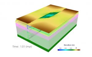
How climate and subsidence control sedimentation along the Norwegian Margin?
Supervisors: Claire Mallard, Tristan Salles, Sabin Zahirovic & John-Are Hansen
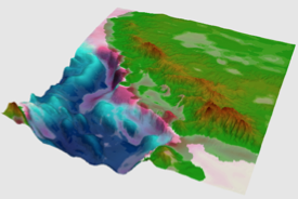 The North Sea Basin and associated Norway margins record extensional tectonic events from the Paleozoic to the Early Cretaceous. A major subsidence phase followed this rifting event throughout the Late Cretaceous and Cenozoic, punctuated by basin inversion episodes during the Paleogene. Both complex tectonic and successive glacial episodes make it hard to understand the evolution of the source to sink systems along this margin from pre-rift to the present day.
Pre-rift sedimentation is characterized by large Jurassic deltaic systems built out in the sea between Norway and Greenland. Then, in the Late Jurassic and Early Cretaceous, significant continental rifting and crustal thinning events occurred inducing a substantial change of depositional facies from deltaic to deep environments. After break-up, glacial events also affected the region resulting in new changes in depositional environments. A model of passive thermal subsidence enhanced by sediment loading in the central North Sea and marginal uplift of the Norwegian landmasses has been proposed. Nevertheless, the role of continued regional and local tectonic activity on the break-up sedimentation is still debated and the timing of onset of glaciation in the Cenozoic, especially for the Quaternary, remains unclear.
The goal of this project is to characterize the processes providing a fundamental control on the drastic changes of depositional environments and sediment fluxes during the rifting history of the Western Norway margin.The first step is to understand the post-rifting sedimentation and how the latest glacial events affected the succession of depositional environments along the Western Norwegian margin. We will use a regional model of the past 30 Ma to test different climate forcing to determine the most realistic ones. The next investigation will focus on the break-up event and how the delta systems are building out into an epicontinental sea between Norway and Greenland, which evolved into the thick Cretaceous shale units. A range of generic models will be designed to test the subsidence scenarios supported by the literature to determine if they allow the same accumulation and depositional environment evolution than on the actual margin. This project is aligned with the Basin GENESIS Hub and will involve collaboration with the oil company Equinor.
How is landscape complexity driving biodiversity over geological time scales?
Supervisors: Patrice Rey & Tristan Salles
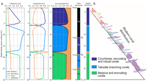
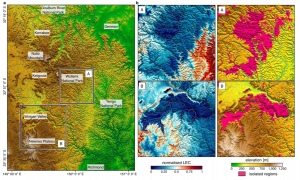 Application of the landscape complexity proxy on the Blue Mountains region (a) highlighting regions of high LEC (i.e. higher biodiversity in b-left) and high isolation (i.e. higher speciation and endemism in b-right).
Mountainous landscapes have long been recognized as potential drivers for genetic drift, speciation and ecological resilience. Yet, there is a lack of clarity on the mechanisms and processes linking landscape complexity to biodiversity over geological time scales.
In most studies, landscape complexity has often been overlooked with species richness evolution only quantified over static landscapes. Consequently, we are still missing a fundamental understanding of how tectonic and surface processes convert landscapes of low elevation and relief, low environmental gradients and continuous habitats, into topographically complex regions of high relief with steep environmental gradients, and fragmented habitats.
Recently a new numerical approach has been proposed to assess and quantify drivers of biodiversity, speciation and endemism over geological time scales. The method is a direct measure of landscape complexity and seems to explain – to the first order – biodiversity in mountainous regions over synthetic landscapes. In this project, we propose to use this new capability (already developed in Badlands) to test its applicability over a range of different mountainous landscapes around the world. From comparisons with available biodiversity dataset, the project will estimate under which conditions this new landscape complexity proxy is a good predictor of species richness. The project outcomes could potentially lead to reassessment of the spatial viability of existing biodiversity conservation sites and could help improve future conservation planning, policy and practice.
Oceanic upwelling and the distribution of deep-sea organic carbon since the Cretaceous Period
Supervisors: Adriana Dutkiewicz and Dietmar Müller
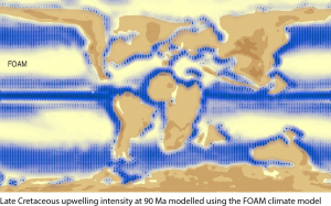 The distribution of sedimentary organic matter in the ocean basins through space and time is of fundamental importance to the global carbon cycle. Deep sea sediments represent an important sink of organic carbon, while subduction of organic carbon contributes to subduction zone degassing of carbon back into the atmosphere. A major challenge is to better constrain the processes that controlled organic carbon production and burial and its consequences for marine biogeochemical cycles. Upwelling of nutrient rich deep water is the primary mechanism driving surface ocean productivity and carbon burial. A secondary process is the influx of terrigenous organic matter to the oceans from the continents. Previous work on organic matter accumulations in deep sea sediments as “black shales” has led to a hypothesis that optimal conditions for black shale deposition should occur where in the outer tropical climate zones and in areas of coastal upwelling with strong forcing by surface winds (Wagner et al., 2013).
This project is designed to test this hypothesis by combining the outputs of a set of global climate-ocean models run using the Fast Ocean Atmosphere Model (FOAM) with deep-sea sedimentary organic carbon data from ocean drilling sites. Climate model outputs include predicted grids of the past distributions and intensity of upwelling through time as well as water runoff from the continents. The objective is to determine spatio-temporal correlations between total sedimentary organic carbon content with key parameters such as the predicted upwelling intensity and latitude, proximity to continents, including whether continents occur to the west or the east of a given region (upwelling tends to be more pronounced along eastern boundary currents) and regional continental runoff. This will lead to a predictive approach for mapping the reservoir of deep-sea organic carbon through time, as well as its subduction flux. The methodology will build on those developed for oceanic crustal carbon and sedimentary carbonate carbon reconstructions in the EarthByte Group. The project will involve collaboration with Prof Christopher Scotese (Director, Paleomap Project) and assistance with workflow development by Michael Chin, and will lead to further opportunities as part of the Basin Genesis Hub and the EarthByte Group’s work on deep carbon and long-term climate change.
References
Dutkiewicz, A., Müller, R.D., Cannon, J., Vaughan, S. and Zahirovic, S., 2018. Sequestration and subduction of deep-sea carbonate in the global ocean since the Early Cretaceous. Geology, 47(1), pp.91-94.
Müller, R.D. and Dutkiewicz, A., 2018. Oceanic crustal carbon cycle drives 26-million-year atmospheric carbon dioxide periodicities. Science Advances, 4(2), p.eaaq0500.
Wagner, T., Hofmann, P., & Flögel, S., 2013, Marine black shale deposition and Hadley Cell dynamics: A conceptual framework for the Cretaceous Atlantic Ocean. Marine and Petroleum Geology, 43, 222-238.
Vertical motions of the Tasman and Coral Sea: possible link to Ontong Java Plateau collision?
Supervisors: Maria Seton & Jody Webster
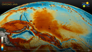 The collision of the world’s largest Large Igneous Province, the Ontong Java Plateau (OJP), with the Melanesian Arc is proposed to have caused subduction polarity reversal along the South Solomon Trench, leading to a cascade of events such as a change in direction of the Australian plate, ore-deposit formation along the Melanesian Arc, and possibly a reorganisation of the entire plate-mantle system. Although this major tectonic event is well-recognised in the literature, determining the timing of plateau accretion is difficult as three independent approaches (palaeomagnetics, marine geophysics and onshore geology) yield timings that differ by over 30 million years.
 In this project, you will use a novel and multi-disciplinary approach to explore the far-field effect of this collision on the vertical motions of the submarine seamounts and ridges in the Tasman and Coral Seas. You will integrate age and paleo-environment data from recently collected sedimentary samples and construct alternative plate kinematic models of the OJP collision in GPlates. The reconstructions will be fed into geodynamic models of mantle structure and the dynamic topography predictions will be compared to your paleo-environmental data. This project involves collaboration with colleagues from the University of Wollongong.
How has subduction influenced the opening of the Drake Passage?
Supervisors: Maria Seton & Dietmar Müller
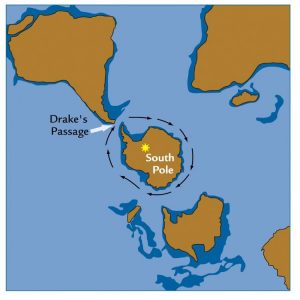 Oceanic gateways are narrow connections between neighbouring oceans and focal areas for the large-scale exchange of water, heat, salinity and nutrients between ocean basins. Their opening and closure, which is largely driven by plate tectonic processes, is thought to be responsible for abrupt climate shifts by altering ocean circulation leading to a change in the distribution of heat, moisture and CO2 in the world’s oceans and atmosphere. However, understanding the relationship between tectonics and climate is strongly dependent on accurate reconstructions of gateway morphology and their margins, which remain poorly constrained.
I n this project, you will explore the relative role of subduction on the Drake Passage and its margins and examine how subduction processes such as back-arc opening and slab window formation may have influenced both the timing of deep-water flow between the Pacific and Atlantic Oceans and the signatures indicating continental separation from the geological record. As part of this project you will develop a new set of plate reconstructions with a particular focus on incorporating the subduction history of southern South America and the Antarctic Peninsula, map the migration of slab windows and create a series of paleobathymetry and palaeoelevation models for the region. You will develop skills in plate tectonic modeling and data synthesis and learn software tools such as GPlates, ArcGIS and GMT. This project could be a catalyst for further studies in using your results as boundary conditions into paleoclimate modelling software.
The tectonic and surface process evolution of Papua New Guinea
Supervisors: Sabin Zahirovic, Claire Mallard, Tristan Salles
 The New Guinea margin has experienced a complex tectonic history due to the convergence between the Indo-Australian, Eurasian and Pacific plates since the breakup of the Pangea supercontinent. The inaccessible terrain in Papua New Guinea, coupled with poor rock exposure due to extreme weathering in the tropical humid belt, result in poorly-constrained models of the regional tectonic and topographic evolution. However, the Papuan Fold and Thrust Belt and the Gulf of Papua host some of the world’s most promising energy resources, meaning that the latest modelling approaches must be applied to help demystify the nature and chronology of major tectonic events that have shaped the region. Tectonic reconstructions in GPlates that include end-member estimates of lithospheric deformation will be linked to landscape evolution models in Badlands, with additional time-evolving boundary conditions applied from CitcomS mantle flow models. The timing and magnitude of (Eocene or Oligocene) deformation related to the collision on the Papuan Peninsula, as well as the Late Cretaceous to Eocene rifting in the western Coral Sea, will inform the time-dependent tectonic topography boundary condition applied to the Badlands models. The predicted stratigraphy will be compared to interpretations of regional seismic sections with the aim of identifying the most plausible tectonic scenarios, as well as help inform paleogeographic interpretations and resource exploration for the north-eastern margin of the Australian continent. This project is firmly aligned with the Basin GENESIS Hub, and will involve close collaboration with Oil Search who is our key industry partner for the New Guinea region.
The role of mechanical stratigraphy in the structural style and development of fold and thrust belts
Supervisors: Patrice Rey & Luke Mahoney (Oil Search)
 The strong variability in the structural style (fold geometries, fault patterns, etc.) of fold and thrust belts is in large part due to the rheological contrasts that can exist between evaporites, shales, sandstones, limestones and volcanic rocks that accumulate in sedimentary basins. The inversion, via forward modelling, of the structural style imaged through seismic methods, can help constrain the mechanical stratigraphy of basins. In this project, the student will use high-performance computers, and open source numerical codes such as Underworld. The aim is to define, via a simple inversion protocol, the mechanical stratigraphy of the fold and thrust belt in Papua New Guinea. This project is a collaboration between the Basin Genesis Hub and Oil Search, a Sydney-based oil and gas exploration company.
Lithospheric mechanical layering and mountain building processes
Supervisors: Patrice Rey & Vasilis Chatzaras
 The topography of continents is the expression of geodynamic and tectonic processes deforming the continental lithosphere. How the continents deform depends on their mechanical properties and their thermal state. A number of rheological models have been proposed for the continental lithosphere varying from the “crème brulée” model, in which the strong upper crust stands above a much weaker lower crust and weaker mantle, to the “jelly sandwich” model, in which a much weaker lower crust separates the stronger upper mantle from the stronger upper crust. In this project, we propose to explore the role of the lithospheric mechanical layering on collisional processes. The candidate will design, run, analyse and compare simulations of continental collision involving a range of rheological layering. Results will be compared to a number of orogens including the Himalayas-Tibet and central Anatolia.
Effect of mechanical layering on lithospheric coupling in strike-slip fault systems
Supervisors: Patrice Rey & Vasilis Chatzaras
 Major strike-slip faults extend through the crust, offsetting the Moho, and may even offset the lithosphere-asthenosphere boundary. As such, these structures require some type of mechanical communication between crust and mantle. In this project we propose to explore the effect of the rheological structure of strike-slip fault zones on the mechanical interaction and degree of coupling between the different lithospheric layers (i.e. upper crust, lower crust, and upper mantle). You will run numerical models of deformation in lithospheric-scale strike-slip faults using a range of mechanical stratifications. You will compare the results of the simulations with observations from major strike-slip faults, such as the San Andreas fault (USA) and the North Anatolian fault (Turkey). High-performance computers, and open source numerical codes such as Underworld will be used to run the simulations. In this project you will develop skills in: 1) geodynamic modelling, and 2) analysis of deformation in transform settings.
Relevant literature
Chatzaras, V., Tikoff, B., Newman, J., Withers, A.C., Drury, M.R., 2015. Mantle strength of the San Andreas fault system and the role of mantle-crust feedbacks. Geology, 43, 891–894, doi:10.1130/G36752.1.
Rey, P. F., Mondy, L., Duclaux, G., Teyssier, C., Whitney, D.L., Bocher, M. and Prigent, C., 2017. The origin of contractional structures in extensional gneiss domes. Geology, v.45, DOI: 10.1130/G38595.1.
Multi-core parallel tempering for extending BayesReef for modelling reef growth on geological timescales
Supervisors: Rohitash Chandra & Jody Webster
 Estimating the impact of environmental processes on vertical reef development in geological timescales is a very challenging task. This is due to complex models and data with missing information. py-Reef Core is a vertical reef growth simulation model for geological timescales. BayesReef has been proposed to estimate and provide uncertainty quantification for py-Reef Core which features environmental condition parameters. BayesReef features limitations when the size of the problem increases due to computational requirements in sampling and hence only a few parameters were estimated. Parallel tempering (PT) is an advanced MCMC method suited for irregular and multi-modal distributions. Moreover, PT is more suitable for multi-core implementations that can speed up computationally expensive geophysical models. The Honours research project extends Bayeslands using parallel tempering to estimate dozens of parameters on a synthetic reef core dataset.
Understanding the link between plate tectonics and landscape-basin evolution
Supervisors: Sara Morón, Sabin Zahirovic, Tristan Salles, Chris Elders (Curtin University)
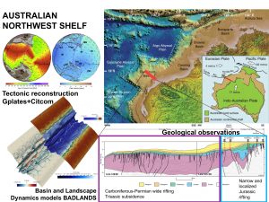 Sedimentary basins capture the Earth’s tectonic and landscape history and host a range of resources of critical importance for the continued functioning of modern society.
The sedimentary basins of the North West Shelf (NWS) of Australia contain an exceptional record of multiple phases of rifting associated with supercontinental breakup. These multiple rift phases which span from the Permian to Cretaceous exhibit contrasting structural and stratigraphic styles. This contrasting record offers an excellent opportunity to investigate the link between plate tectonics and landscape-basin evolution. This project will use a combination of (i) plate tectonic reconstructions, (ii) basin and landscape dynamics numerical models and (iii) a synthesis of geological observations to unravel the link between plate tectonics and landscape-basin evolution. Models will allow exploring (i) how temporal structural changes can be associated to changes in the direction of rifting, (ii) how variations in the stratigraphic record are the result of variations in the flux of sediments from the continent interior to the continental margin and (iii) the interaction between plate tectonics and landscape-basin evolution. This project provides an extraordinary opportunity to learn about tectonics and surface processes with cutting-edge software tools, which will give students a valuable set of skills that are important for both academia and industry.
Fingerprinting the closure of the Central American Seaway
Supervisors: Sara Morón, Maria Seton, Tristan Salles
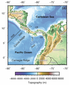 The Central American Seaway facilitated the exchange of water, heat, salinity and biota between the Pacific and Atlantic oceans. The closure of this oceanic gateway, at the Isthmus of Panama, has been attributed to the onset of northern hemisphere glaciation, the formation of North Atlantic Deep Water and the great biotic exchange between North and South America during the Pliocene. However, the timing of gateway closure is controversial with ages ranging from Paleocene-Eocene through to the Pliocene, requiring a rethink of our understanding of global ocean circulation patterns and biotic exchange through this gateway. You will attempt to address this controversy by comparing mapped fluvial systems from southern North America and northern South America with results from landscape evolution software, Badlands. You will acquire a wide variety of skills in data synthesis and numerical modelling (GPlates, Badlands, GMT). This project forms part of the ARC-funded Basin Genesis Hub.
A newly discovered plate boundary in the North Fiji Basin – why is it there?
Supervisors: Maria Seton, Julian Giodarni
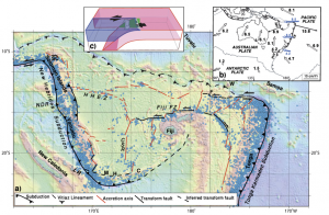 The most complex arrangement of mid-ocean ridges on Earth exists in the late Miocene-present North Fiji Basin. While many of the spreading centres have been mapped through a combination of earthquake focal mechanisms, high-resolution geophysical data, and direct sampling, others have been inferred. One such example is an accretionary axis close to the New Hebrides subduction zone. In this project, you will interpret newly collected marine geophysical data from the North Fiji Basin to map a newly discovered plate boundary and then use numerical experiments using Underworld to explore whether the collision of the Loyalty Ridge could led to the arrangements of plate boundaries we currently observe in the southwest North Fiji Basin. The results of the experiments will help inform on the dynamics of arc collision and overriding plate deformation. As part of this project, you will acquire skills in marine geophysical data analysis, GIS and numerical modeling. These skills will help prepare you for working in the exploration industry, consulting firms, government agencies or universities. This project will involve close collaboration with colleagues from the University of Melbourne.
Coupling pyGPlates with thermal diffusion models: a case study on how subduction rates impact the thermal regime in Alaska
Supervisors: Ben Mather, Dietmar Muller
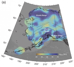 The present-day temperature distribution of the Earth’s lithosphere inherits geological processes that have occurred tens of millions of years ago. Recent seismic data acquired in Alaska capture two horizons that obscure the Moho, which is probably related to interference with the eastward-subducting slab. In this project, the candidate will use pyGPlates to interrogate the position and velocity of the subducting slab through the last 80 million years and couple a simplified model of thermal diffusion to simulate the thermal evolution of the lithosphere. The region is currently thermally active, as shown by the presence of numerous hot springs, but very little is known about the composition of the lithosphere in Alaska. By merging pyGPlates with a model of thermal diffusion that assimilates multiple observations related to temperature (e.g. Curie depth, heat flow measurements, crustal thickness) the candidate will be able to quantify the present-day thermal regime to some degree of uncertainty. The project will develop the candidate’s skills in the Python programming language and Bayesian inference. This project will be undertaken in close collaboration with researchers at the Australian National University in Canberra.
Inverting the present-day temperature distribution in Australian crust at unprecedented resolution
Supervisors: Ben Mather, Dietmar Muller
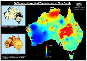 Understanding the thermal structure of the crust is key to informing regions that are desirable for geothermal exploration or hydrocarbon maturity. Furthermore, temperature is a requirement to ascertain the rheology of the crust to identify regions that are more susceptible to deformation. Despite there being numerous attempts to characterise the temperature distribution in Australia, the thermal structure of the crust in Australia is relatively unknown. Most temperature maps ignore the geological complexity of different terranes and sedimentary basins within Australia and focus only in the top 5km of the crust. In this project, the honours candidate will invert the temperature of Australia’s crust using high performance computing (HPC) infrastructure. The project will leverage an in-house Python code developed to efficiently find an optimal temperature solution, subject to available data, which also produces uncertainty estimates. This project will develop the candidate’s skills in the Python programming language and Bayesian inference. This project will be undertaken in close collaboration with researchers at the Australian National University in Canberra.
![]()
