ASEG will be hosting their next technical meeting on Wednesday 20th April, featuring EarthByter Ehsan Farahbakhsh
Title: The use of machine learning in processing remote sensing data for mineral exploration
Time: 5:30 pm for 6:00 pm start
Address: Level 2, 99 on York (99 York St, Sydney. Room ‘York 2’)
For virtual attendance, please register using the following link: https://us02web.zoom.us/webinar/register/WN_2iHaItV9Sk201SP4ZFkPpw
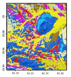
Summary: The decline of the number of newly discovered mineral deposits and increase in demand for critical minerals in recent years has led exploration geologists to look for more efficient and innovative methods for processing different data types at each stage of mineral exploration. As a primary step, various features, such as lithological units, alteration types, structures, and indicator minerals, are mapped to aid decision-making in targeting ore deposits. Different types of remote sensing datasets, such as satellite and airborne data, make it possible to overcome common problems associated with mapping geological features. The rapid increase in the volume of remote sensing data obtained from different platforms has encouraged scientists to develop advanced, innovative, and robust data processing methodologies. Machine learning methods can help process a wide range of remote sensing datasets and determine the relationship between components such as the reflectance continuum and features of interest. These methods are robust in processing spectral and ground truth measurements against noise and uncertainties. In this presentation, I will provide a brief introduction to remote sensing data types and review the implementation and adaptation of some popular and recently established machine learning methods for processing different types of remote sensing data aiming at detecting various ore deposit types. I will also review our recent studies on combining remote sensing data and machine learning methods for mapping different geological features that are critical for providing mineral potential maps.
![]()
