EarthByte has now released a list of Honours/Masters projects to be offered in 2019. These projects are outlined below.
If you are interested in learning more about any of these projects, please get in contact with the project supervisors.
How is landscape complexity driving biodiversity over geological time scales?
Supervisors: Tristan Salles & Patrice Rey
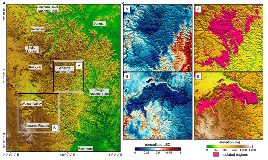
Mountainous landscapes have long been recognized as potential drivers for genetic drift, speciation and ecological resilience. Yet, there is a lack of clarity on the mechanisms and processes linking landscape complexity to biodiversity over geological time scales.
In most studies, landscape complexity has often been overlooked with species richness evolution only quantified over static landscapes. Consequently, we are still missing a fundamental understanding of how tectonic and surface processes convert landscapes of low elevation and relief, low environmental gradients and continuous habitats, into topographically complex regions of high relief with steep environmental gradients, and fragmented habitats.
Recently a new numerical approach has been proposed to assess and quantify drivers of biodiversity, speciation and endemism over geological time scales. The method is a direct measure of landscape complexity and seems to explain – to the first order – biodiversity in mountainous regions over synthetic landscapes. In this project, we propose to use this new capability (already developed in Badlands) to test its applicability over a range of different mountainous landscapes around the world. From comparisons with available biodiversity dataset, the project will estimate under which conditions this new landscape complexity proxy is a good predictor of species richness. The project outcomes could potentially lead to
reassessment of the spatial viability of existing biodiversity conservation sites and could help improve future conservation planning, policy and practice.
How well are tectonic and climatic signals preserved in the stratigraphic record?
Supervisors: Tristan Salles & Claire Mallard
Earth-surface processes operate across erosionally dominated landscapes and deliver sediment to depositional systems that can be preserved over a range of timescales. The geomorphic and stratigraphic products of this source-to-sink sediment transfer record signals of external, allogenic environmental conditions, as well as internal, autogenic dynamics. Due to the nonlinear relationships between these allogenic forcing and transient sediment delivery from erosional catchments, it remains challenging to extract paleo-tectonic and climatic signals from the stratigraphy record.
In this project, using a set of numerical tools (Badlands model & companion), you will evaluate sediment supply and simulated sedimentary record within a source-to-sink context and under different forcing conditions. From a series of synthetic models, you will explore and quantify how stratigraphic evolution responds to (1) variable uplift/subsidence conditions, (2) differences in amplitude and frequencies of sea-level fluctuations and (3) a combination of (1) & (2).
In the upstream region (source area), this project will help to quantify the importance of network dynamics for understanding environmental signals propagation. In sedimentary basins (sink area), it will evaluate under which conditions tectonic and climatic signals have the potential to be stored and preserved in the stratigraphic record or lost in an erosional system.
Vertical motions of the Tasman and Coral Sea: possible link to Ontong Java Plateau collision?
Supervisors: Maria Seton & Jody Webster
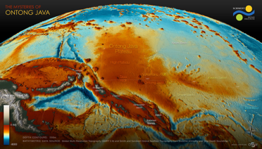 The collision of the world’s largest Large Igneous Province (LIP), the Ontong Java Plateau (OJP), with the Melanesian Arc has been proposed as the cause of a localised subduction polarity reversal event along the South Solomon Trench. This reversal is believed to have led to a cascade of events such as a change in direction of the Australian plate, ore-deposit formation along the Melanesian Arc, and possibly a reorganisation of the entire plate-mantle system. Although this major tectonic event is well-recognised in the literature, determining the timing of plateau accretion is difficult; three independent approaches (palaeomagnetics, marine geophysics and onshore geology) yield timings that differ by over 30 million years.
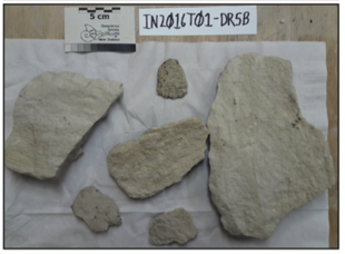 In this project, you will address this controversy using a novel and multi-disciplinary approach that explores the far-field effect of this collision on the vertical motions of the submarine ridges in the Tasman and Coral Seas. You will integrate age and paleo-environment data from sedimentary samples, including those collected from recent voyages IN2016_T01 on the RV InvestiSubduction influence on the evolving oceanic gateway between South America and Antarcticgator and SS2013_v06 on the RV Southern Surveyor. You will then construct alternative
plate kinematic models of the OJP collision in GPlates, which will be fed into geodynamic models of mantle structure and dynamic topography. Lastly, you will assess which coupled plate kinematic-geodynamic model best reflects the vertical motions predicted by your samples. As part of this project, you will have the unique opportunity to go on a 28 day research voyage to the Coral Sea where more samples will be recovered that may be used in your project. This project involves collaboration with colleagues from the University of Wollongong.
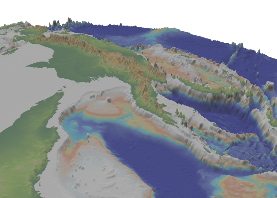
Subduction influence on the evolving oceanic gateway between South America and Antarctica
Supervisors: Maria Seton & Dietmar Müller
Oceanic gateways are narrow connections between neighbouring oceans and focal areas for the large-scale exchange of water, heat, salinity and nutrients between ocean basins. Their opening and closure, which is largely driven by plate tectonic processes, is thought to be responsible for abrupt climate shifts by altering ocean circulation leading to a change in the distribution of heat, moisture and CO2 in the world’s oceans and atmosphere. However, understanding the relationship between tectonics and climate is strongly dependent on accurate reconstructions of gateway morphology and their margins, which remain poorly constrained.
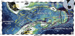
In this project, you will explore the relative role of subduction on the Drake Passage and its margins and examine how subduction processes such as back-arc opening and slab window formation may have influenced both the timing of deep-water flow between the Pacific and Atlantic Oceans and the signatures indicating continental separation from the geological record. As part of this project you will develop a new set of plate reconstructions with a particular focus on incorporating the subduction history of southern South America and the Antarctic Peninsula, assess the development of slab windows in the area and create a series of paleobathymetry and palaeoelevation models for the region. You will develop skills in plate tectonic modeling and data synthesis and learn software tools such as GPlates, ArcGIS and GMT. This project could be a catalyst for further studies in using your results as boundary conditions into paleoclimate modelling software.
The tectonic and surface process evolution of Papua New Guinea
Supervisors: Sabin Zahirovic. Tristan Salles, Dietmar Müller
 The New Guinea margin has experienced a complex tectonic history due to the convergence between the Indo-Australian, Eurasian and Pacific plates since the breakup of the Pangea supercontinent. The inaccessible terrain in Papua New Guinea, coupled with poor rock exposure due to extreme weathering in the tropical humid belt, result in poorly-constrained models of the regional tectonic and topographic evolution. However, the Papuan Fold and Thrust Belt and the Gulf of Papua host some of the world’s most promising energy resources, meaning that the latest modelling approaches must be applied to help demystify the nature and chronology of major tectonic events that have shaped the region. Tectonic reconstructions in GPlates that include end-member estimates of lithospheric deformation will be linked to landscape evolution models in B
adlands, with additional time-evolving boundary conditions applied from CitcomS mantle flow models. The timing and magnitude of (Eocene or Oligocene) deformation related to the collision on the Papuan Peninsula, as well as the Late Cretaceous to Eocene rifting in the western Coral Sea, will inform the time-dependent tectonic topography boundary condition applied to the Badlands models. The predicted stratigraphy will be compared to interpretations of regional seismic sections with the aim of identifying the most plausible tectonic scenarios, as well as help inform paleogeographic interpretations and resource exploration for the north-eastern margin of the Australian continent. This project is firmly aligned with the Basin GENESIS Hub, and will involve close collaboration with Oil Search who is our key industry partner for the New Guinea region.
The role of mechanical stratigraphy in the structural style and development of fold and thrust belts
Supervisors: Patrice Rey & Luke Mahoney (Oil Search)
 The strong variability in the structural style (fold geometries, fault patterns, etc.) of fold and thrust belts is in large part due to the rheological contrasts that can exist between evaporites, shales, sandstones, limestones and volcanic rocks that accumulate in sedimentary basins. The inversion, via forward modelling, of the
structural style imaged through seismic methods, can help constrain the mechanical stratigraphy of basins. In this project, the student will use high-performance computers, and open source numerical codes such as Underworld. The aim is to define, via a simple inversion protocol, the mechanical stratigraphy of the fold and thrust belt in Papua New Guinea. This project is a collaboration between the Basin Genesis Hub and Oil Search, a Sydney-based oil and gas exploration company.
Lithospheric mechanical layering and mountain building processes
Supervisors: Patrice Rey & Vasilis Chatzaras
 The topography of continents is the expression of geodynamic and tectonic processes deforming the continental lithosphere. How the continents deform depends on their mechanical properties and their thermal state. A number of rheological models have been
proposed for the continental lithosphere varying from the “crème brulée” model, in which the strong upper crust stands above a much weaker lower crust and weaker mantle, to the “jelly sandwich” model, in which a much weaker lower crust separates the stronger upper mantle from the stronger upper crust. In this project, we propose to explore the role of the lithospheric mechanical layering on collisional processes. The candidate will design, run, analyse and compare simulations of continental collision involving a range of rheological layering. Results will be compared to a number of orogens including the Himalayas-Tibet and central Anatolia.
Effect of mechanical layering on lithospheric coupling in strike-slip fault systems
Supervisors: Patrice Rey & Vasilis Chatzaras
 Major strike-slip faults extend through the crust, offsetting the Moho, and may even offset the lithosphere-asthenosphere boundary. As such, these structures require some type of mechanical communication between crust and mantle. In this project we propose to explore the effect of the rheological structure of strike-slip fault zones on the mechanical interaction and degree of coupling between the different lithospheric layers (i.e. upper crust, lower crust, and upper mantle). You will run numerical models of deformation in lithospheric-scale strike-slip faults using a range of mechanical stratifications. You will compare the results of the simulations with observations from major strike-slip faults, such as the San Andreas fault (USA) and the North Anatolian fault (Turkey). High-performance computers, and open source numerical codes such as Underworld will be used to run the simulations. In this project you will develop skills in: 1) geodynamic modelling, and 2) analysis of deformation in transform settings.
Relevant literature
Chatzaras, V., Tikoff, B., Newman, J., Withers, A.C., Drury, M.R., 2015. Mantle strength of the San Andreas fault system and the role of mantle-crust feedbacks. Geology, 43, 891–894, doi:10.1130/G36752.1.
Rey, P. F., Mondy, L., Duclaux, G., Teyssier, C., Whitney, D.L., Bocher, M. and Prigent, C., 2017. The origin of contractional structures in extensional gneiss domes. Geology, v.45, DOI: 10.1130/G38595.1.
Multi-core parallel tempering for extending BayesReef for modelling reef growth on geological timescales
Supervisors: Rohitash Chandra, Tristan Salles, Jody Webster
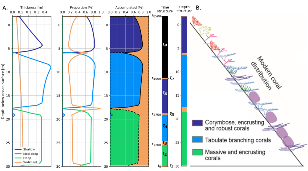
Estimating the impact of environmental processes on vertical reef development in geological timescales is a very challenging task. This is due to complex models and data with missing information. py-Reef Core is a vertical reef growth simulation model for geological timescales. BayesReef has been proposed to estimate and provide uncertainty quantification for py-Reef Core which features environmental condition parameters. BayesReef features limitations when the size of the problem increases due to computational requirements in sampling and hence only a few parameters were estimated. Parallel tempering (PT) is an advanced MCMC method suited for irregular and multi-modal distributions. Moreover, PT is more suitable for multi-core implementations that can speed up computationally expensive geophysical models. The Honours research project extends Bayeslands using parallel tempering to estimate dozens of parameters on a synthetic reef core dataset.
The effect of carbonate sediment subduction through time on crustal mineralisation
Supervisors: Adriana Dutkiewicz, Rohitash Chandra, Dietmar Müller
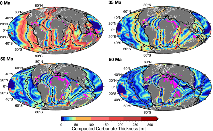
The subduction of carbonate sediments is known to drive a variety of geological processes on the overriding plate, including particular types of metamorphism, magmatism and mineralisation. Subducted carbonates form diapirs that move rapidly upwards through the mantle wedge, reacting with peridotite, assimilating silicate minerals and releasing CO2. This promotes the formation and emplacement of diamonds, metal alloys, carbonatites and so-called ophicarbonates, rocks consisting of serpentine and carbonate. Up to now, there was no framework to map the space-time dependence of carbonate subduction. Our recent work in modelling the accumulation of carbonate sediments on the ocean floor through time makes it possible to investigate how the regional subduction of history of these deep-sea sediments might be linked to the geology of the overriding plates. In this project, we will combine our global plate tectonic model with our deep-sea carbonate sedimentation model to predict the volume of carbonate subduction through time along all subduction zones since the Early Cretaceous Period, when pelagic carbonate producing plankton became widespread. The main objective is to understand how the subduction of carbonates is related to the variety of
carbonate-related rocks and minerals in the continental crust along subduction zones. Addressing this question will involve spatio-temporal data mining using the pyGPlates python library and machine learning techniques, linking the Deep Carbon Observatory minerals database and other relevant data to our time-dependent model. In this project, will develop skills in global “Big Data” analysis and spatio-temporal data mining and machine learning tools, particularly python tools such as Scikit-learn and TensorFlow, which are widely used across difference science domains to solve complex, multi-dimensional problems. The project is part of a Deep Carbon Observatory-funded grant and will lead to future opportunities in the fast growing research field where artificial intelligence is used to solve big picture, complex Earth science problems. The project involves collaboration between the School of Geosciences and the Centre for Translational Data Science (CTDS) and may lead into a career path of data science, mineral exploration, or marine geology.
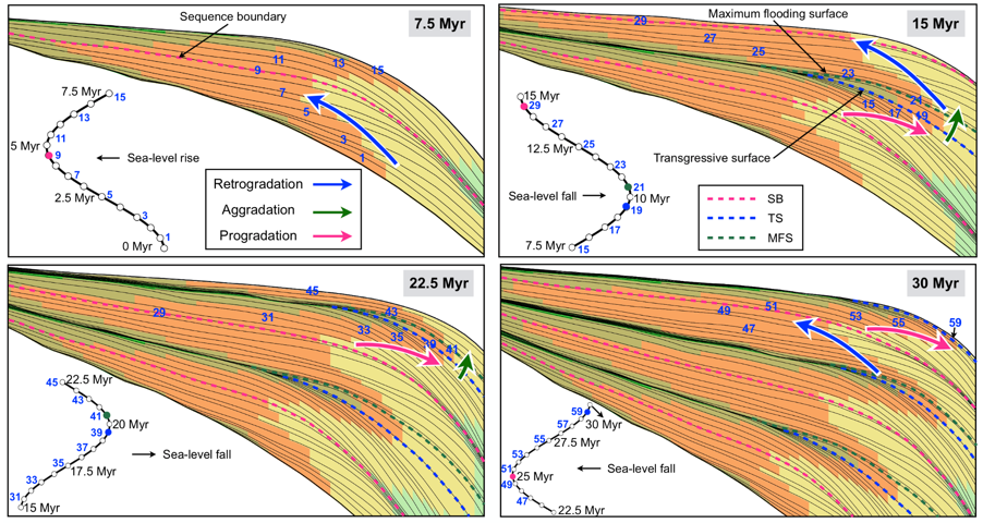
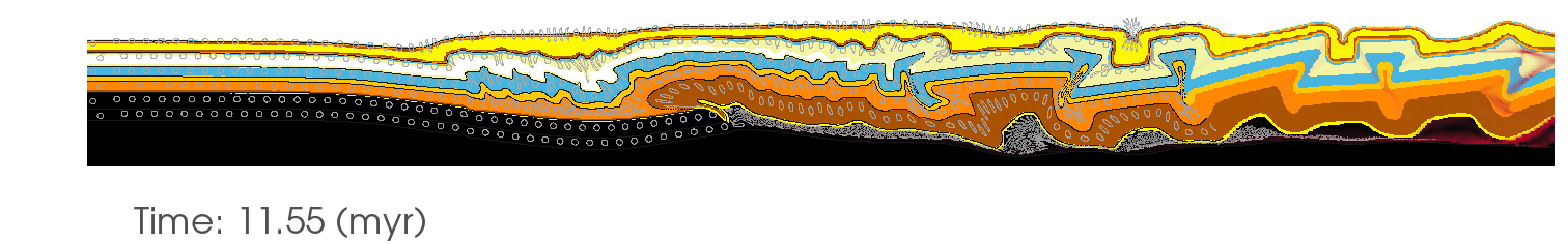
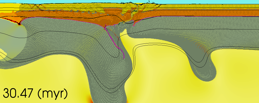
The effect of the structural history on the sedimentation of passive margins
Supervisors: Claire Mallard, Tristan Salles & Dietmar Müller
Passive continental margins represent a system of long-lived natural resources (Bradley 2008). A range of different methods such as deep-sea drilling and seismic reflection have shown that it is impossible to find an example of a ‘classical’ model of margin evolution. Passive margins have existed on Earth almost continually since 2740 Ma, which implies a substantial variety of structural and sedimentation histories. The continental margin of the Alaskan North Slope is a good example of such complexity. It consists of three sectors of contrasting structure and stratigraphy. The western sector is characterized by a deep late Mesozoic and Tertiary basin and a continental borderland. The central sector is characterised by continental terrace built of Albian to Tertiary clastic sediments and the northeastern sector contains thick layers of Jurassic, Cretaceous and Tertiary marine and non-marine clastic sediments (Grantz et al., 1979). The distinguishing sedimentation histories of the three sectors are inherited from the different tectonic morphologies of the rift that separated Arctic Alaska from the Canadian Arctic Archipelago relative to pre-existing rift highlands, which acted as clastic sediment sources (Grantz et al., 1979). Our Badlands landscape and evolution code is opening up new avenues to investigate the complexity of the stratigraphic evolution coupled with different 3D thermo-mechanical models. In this project, the simulation of the architecture of sedimentary units, such as the progradation and downlap of foresets, backstepping and fluvial onlap, subaerial truncation and incised valleys, will be investigated (See figure from Ramon-Duenas et al., 2018). The goal of this project is to understand the stratigraphic architecture of the basins, taking into account their structural evolution at a regional scale. It will allow to better understand the time significance assigned to the geometries traditionally labelled ‘pre-rift, syn-rift and sag’. These models will enable “synthetic geophysical profiling” – synthetic stratigraphy (akin to seismic) profiles across basins) – to underpin decision-making for exploration. The project is offered as part of the ARC Basin Genesis Hub, and involves opportunities to interact with our industry partners.
Grantz, A., Eittreim, S. and Dinter, D.A., (1979) Geology and tectonic development of the continental margin north of Alaska. Tectonophysics, 59: 263–291.
Bradley, D., C., (2008) Passive margins through earth history. Earth Science Reviews 91:1–26.
Ramon-Duenas, C., Rudolph, K., W., Emmet, P., A., Wellner, J., S., (2018) Quantitative analysis of siliciclastic clinoforms: An example from the North Slope, Alaska. Marine and Petroleum Geology, 93: 127-134.
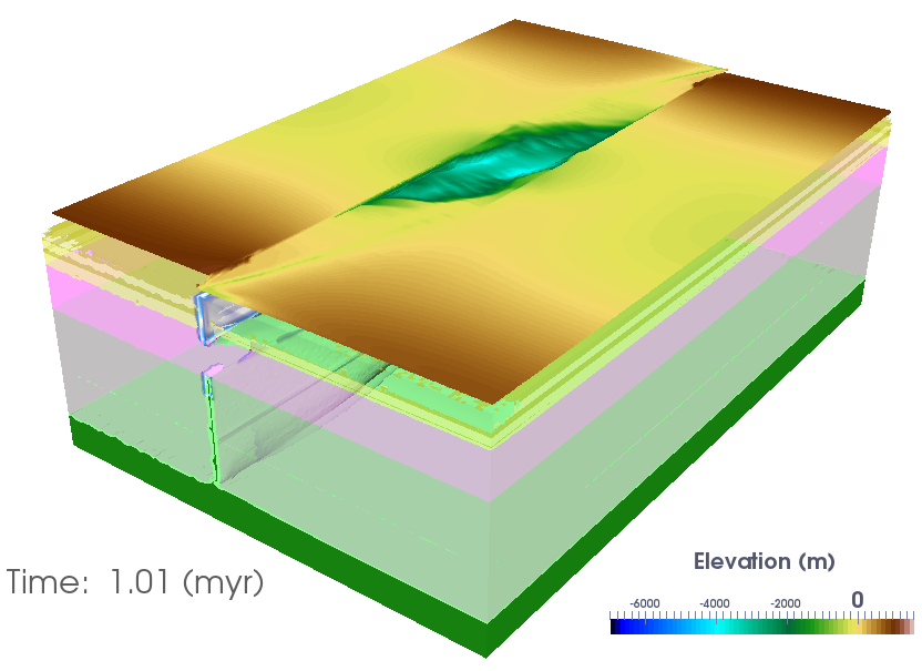
Understanding the link between plate tectonics and landscape-basin evolution
Supervisors: Sara Morón, Sabin Zahirovic, Chris Elders (Curtin University) & Tristan Salles
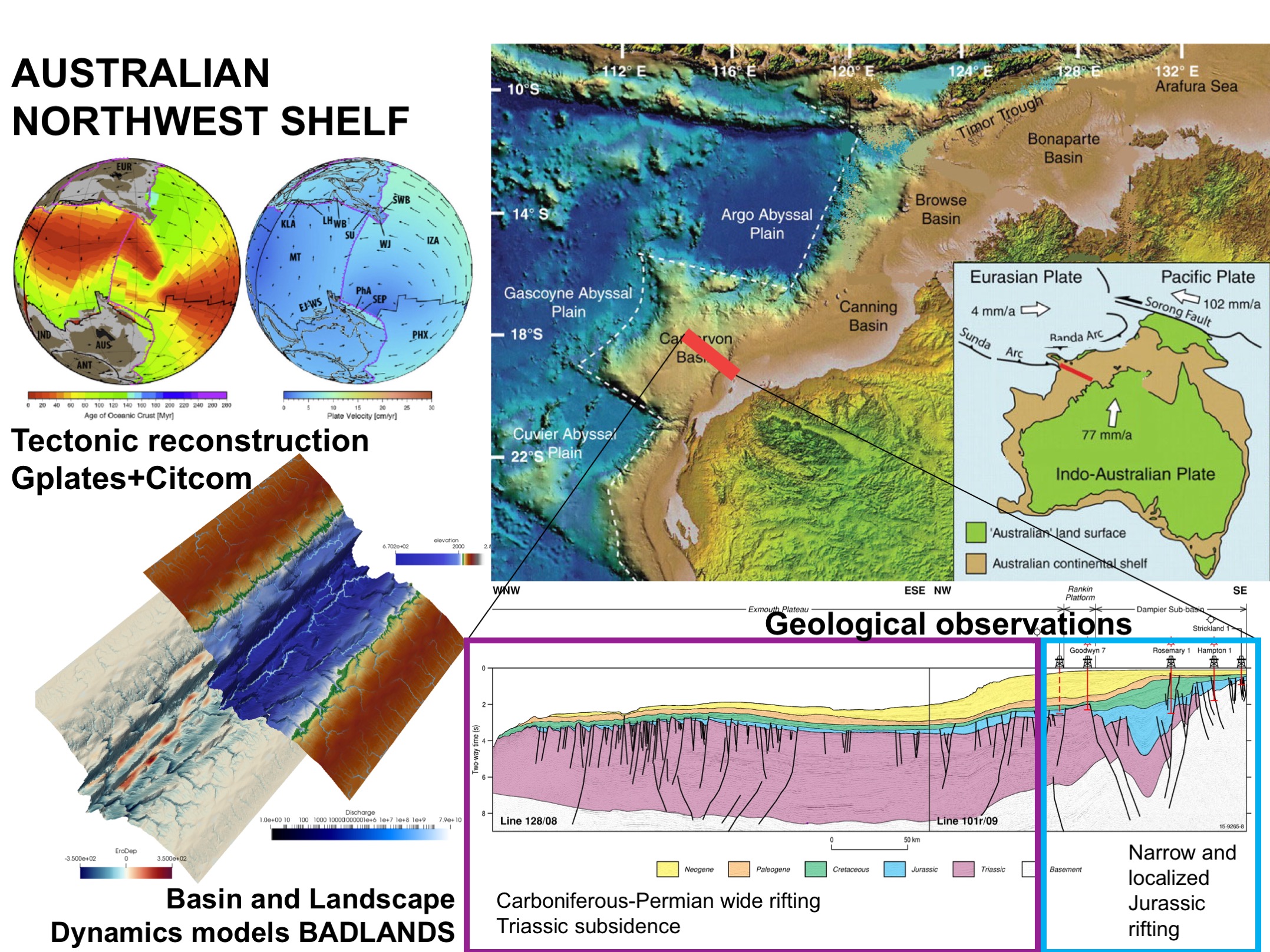 Sedimentary basins capture the Earth’s tectonic and landscape history and host a range of resources of critical importance for the continued functioning of modern society.
The sedimentary basins of the North West Shelf (NWS) of Australia contain an exceptional record of multiple phases of rifting associated with supercontinental breakup. These multiple rift phases which span from the Permian to Cretaceous exhibit contrasting structural and stratigraphic styles. This contrasting record offers an excellent opportunity to investigate the link between plate tectonics and landscape-basin evolution. This project will use a combination of (i) plate tectonic reconstructions, (ii) basin and landscape dynamics numerical models and (iii) a synthesis of geological observations to unravel the link between plate tectonics and landscape-basin evolution. Models will allow exploring (i) how temporal structural changes can be associated to changes in the direction of rifting, (ii) how variations in the stratigraphic record are the result of variations in the flux of sediments from the continent interior to the continental margin and (iii) the interaction between plate tectonics and landscape-basin evolution. This project provides an extraordinary opportunity to learn about tectonics and surface processes with cutting-edge software tools, which will give students a valuable set of skills that are important for both academia and industry.
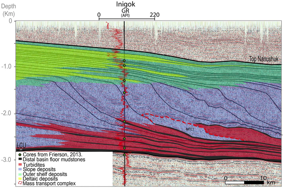
The interaction of tectonic and surface processes on the post-Jurassic North Slope of Alaska
Supervisors: Sabin Zahirovic, Tristan Salles, Claire Mallard & Daniela Garrad (Oil Search)
The North Slope of Alaska is a prolific resource-rich region with a complex tectonic and geodynamic history. Unravelling the geological history using the sedimentary record can only be achieved when considering the interaction of tectonics, deep mantle flow, sea level, and surface processes over geological time. This project will explore the Jurassic to present evolution of this region in the context of new deforming plate reconstructions in GPlates, the latest dynamic topography estimates from new geodynamic models in CitcomS, and surface process models using the cutting-edge Badlands software. In particular, this project will for the first time make use of the isostatic topography from the GPlates deforming models and new software functionality to combine it with new Extended Boussinesq Approximation-derived dynamic topography, as well as new sea level curves. The student will need to use paleogeographic models from the USGS to derive the initial topography in Badlands, and will use vertical motions applied from GPlates and CitcomS, as well as horizontal motions from the deforming model in GPlates, as boundary conditions to the surface process models in Badlands. The project will also explore the role of longshore drift and other terrestrial and marine sediment transport mechanisms in order to better constrain the evolution of this margin. This project is firmly aligned with the Basin GENESIS Hub, and will involve close collaboration with Oil Search who have a major project currently underway in understanding the energy resources of the North Slope of Alaska basins.
![]()
