A new research paper published in Ore Geology Reviews based on a collaboration between Dr. Behnam Sadeghi from EarthByte Group, USYD, and several research institutes in China, including:
- China University of Geosciences: State Key Laboratory of Geological Processes and Mineral Resources
- Hebei GEO University: 1) Institute of Resource and Environmental Engineering, 2) Hebei Key Laboratory of Strategic Critical Mineral Resources, and 3) Hebei Key Laboratory of Optoelectronic Information and Geo-detection Technology.
Abstract:
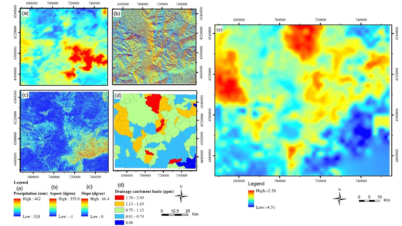
Geochemical anomaly mapping is a crucial part of environmental and mineral exploration projects. Stream sediments are the most frequently sampling medium for geochemical mapping in regional scales, resulting from various geological processes. To enhance geochemical anomalies in stream sediments, the geochemical landscape, including topographic factors and drainage catchment basin extracted from a digital elevation model (DEM), and average precipitations, were applied. These factors were taken into consideration in this research to investigate the influence of the geochemical landscape constraints on the Mo polymetallic mineralization anomaly of stream sediments in a typical hilly area of Jining, Inner Mongolia, China, using Bayesian Maximum Entropy (BME) approach. Geographically weighted regression was applied to construct probability density function of soft data based on slope, aspect, drainage catchment basin, and precipitation. Stream sediment data, at a scale of 1:200,000 (hard data), was integrated with the soft data to map stream sediment anomalies associated with molybdenum-polymetallic mineralization. Considering the influences of geochemical landscape during stream sediment anomaly identification can make up the shortage of missing and incomplete observations in regional geochemical data. By integrating the geochemical landscape factors during the stream sediment anomaly identification process, the impacts of the geochemical landscape on sediment dispersion halos were addressed, and the anomaly identification accuracy was improved. The anomaly areas defined by the BME model demonstrated that 31.41% of the study area contained 75% of the known mineral deposits and consequently the uncertainty of geochemical anomalies was reduced.
Link: https://doi.org/10.1016/j.oregeorev.2022.104715
![]()
