
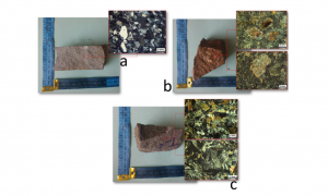
Lithological mapping is a critical aspect of geological mapping that can be useful in studying the mineralization potential of a region and has implications for mineral prospectivity mapping. This is a challenging task if performed manually, particularly in highly remote areas that require a large number of participants and resources. The combination of machine learning (ML) methods and remote sensing data can provide a quick, low-cost, and accurate approach for mapping lithological units. This study used deep learning via convolutional neural networks and conventional ML methods involving support vector machines and multilayer perceptron to map lithological units of a mineral-rich area in the southeast of Iran. Moreover, we used and compared the efficiency of three different types of multispectral remote-sensing data, including Landsat 8 operational land imager (OLI), advanced spaceborne thermal emission and reflection radiometer (ASTER), and Sentinel-2. The results show that CNNs and conventional ML methods effectively use the respective remote-sensing data in generating an accurate lithological map of the study area. However, the combination of CNNs and ASTER data provides the best performance and the highest accuracy and adaptability with field observations and laboratory analysis results so that almost all the test data are predicted correctly. The framework proposed in this study can be helpful for exploration geologists to create accurate lithological maps in other regions by using various remote-sensing data at a low cost.
Shirmard, H., Farahbakhsh, E., Heidari, E., Beiranvand Pour, A., Pradhan, B., Müller, D. and Chandra, R., 2022. A Comparative Study of Convolutional Neural Networks and Conventional Machine Learning Models for Lithological Mapping Using Remote Sensing Data. Remote Sensing, 14(4), p.819.
![]()
