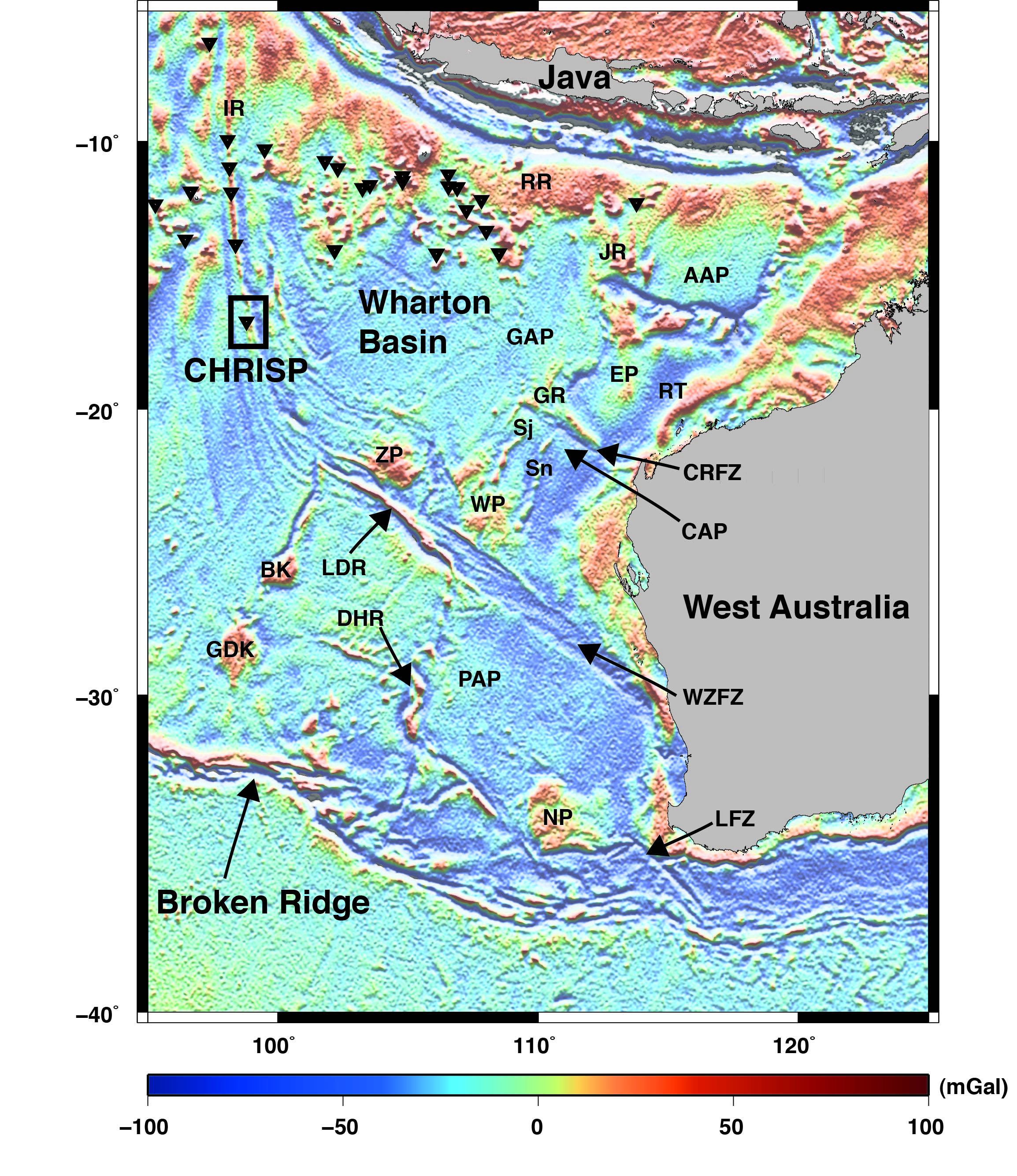
 We present the Indian Ocean plate tectonic model accompanying the study of Gibbons et al., (2012). This work details the first regional-scale tectonic model of the breakup of East Gondwana. Our model shows that the breakup of East Gondwana started with the migration of a continental sliver, Argoland, in the Late Jurassic and was followed by breakup between Greater India and Australia-Antarctica in the Early Cretaceous, involving spreading reconfigurations, which left several sunken continental plateaus of Indian crust on the Australian plate. New evidence from seafloor off northwest Australia also shows that the majority of Greater India reached only about halfway up the West Australian margin, to the Wallaby-Zenith Plateaus. … Read more…
Prof Dietmar Müller
 Group Coordinator
Phone: +61 2 9351 4255
Fax: +61 2 9351 3644
School of Geosciences
The University of Sydney
Sydney, NSW 2006
Australia
View Dietmar's Sydney Uni page
See below for EarthByte content related to Dietmar.

EarthByte welcomes Sarah Maher
EarthByte would like to welcome Sarah Maher from the University of Hawaii who will be working with Dietmar Müller and Maria Seton on African absolute plate motions.
Geology – Early to middle Miocene monsoon climate in Australia: REPLY
Herold, N., Huber, M., Greenwood, D. R., Müller, R. D., & Seton, M. (2011). Early to middle Miocene monsoon climate in Australia. Geology, 39(1), 3-6. doi: 10.1130/G33384Y.1. Download the paper – pdf
Geochemistry Geophysics Geosystems – Constraining the Jurassic extent of Greater India: Tectonic evolution of the West Australian margin
Gibbons, A. D., Barckhausen, U., den Bogaard, P., Hoernle, K., Werner, R., Whittaker, J. M., & Müller, R. D. (2012). Constraining the Jurassic extent of Greater India: Tectonic evolution of the West Australian margin. Geochemistry, Geophysics, Geosystems, 13(5). doi:10.1029/2011GC003919. Download the paper – pdf
Solid Earth – The link between great earthquakes and the subduction of oceanic fracture zones
Müller, R. D., & Landgrebe, T. C. W. (2012). The link between great earthquakes and the subduction of oceanic fracture zones. Solid Earth, 3(2), 447-465. doi:10.5194/se-3-447-2012. Link to download the paper
An open-source software environment for visualizing and refining plate tectonic reconstructions using high-resolution geological and geophysical data sets
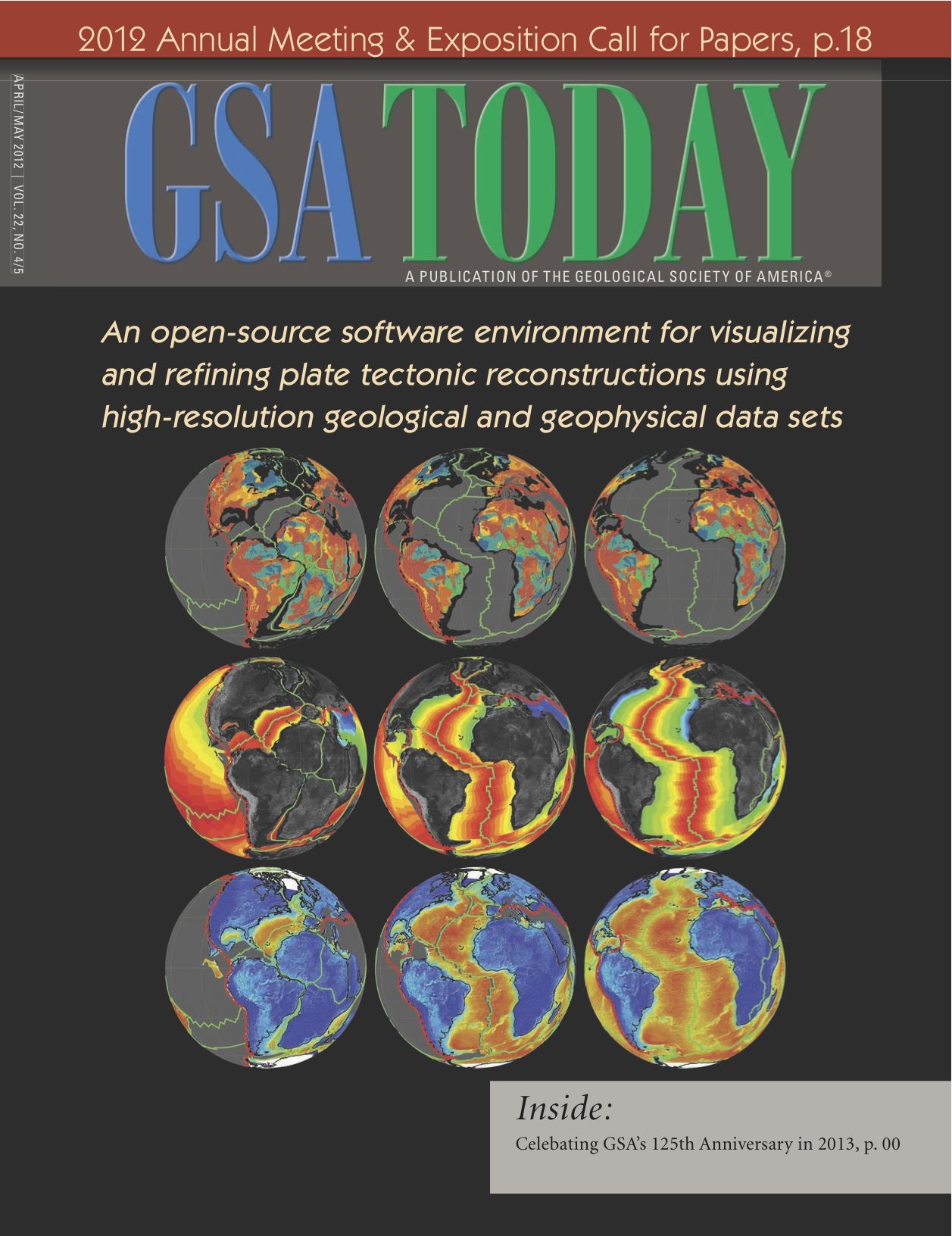 We describe a powerful method to explore spatio-temporal relationships within geological and geophysical data sets by analyzing the data within the context of tectonic reconstructions. GPlates is part of a new generation of plate reconstruction software that incorporates functionality familiar from GIS software with the added dimension of geological time. Here we use GPlates to reconstruct geological terranes, geophysical grids, and paleomagnetic data within alternative tectonic models of the assembly of Western Australia and the configuration of Rodinia. With the ability to rapidly visualize a diverse range of geological and geophysical constraints within different reconstructions, users can easily investigate the implications of different tectonic models for reconciling a variety of observations and make more informed choices between different models and data. … Read more…
Insights on the kinematics of the India-Eurasia collision from global geodynamic models
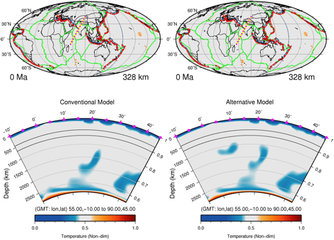 We present the input plate motion models and results from the study by Zahirovic et al. (2012) on the India-Eurasia collision using linked kinematic and geodynamic models.
Two end-member scenarios of the India-Eurasia collision were tested. The conventional model invokes long-lived Andean-style subduction along southern Eurasia until continental collision between a maximum extent Greater India and Lhasa at ~60 Ma. … Read more…
G-Cubed – Insights on the kinematics of the India-Eurasia collision from global geodynamic models
Zahirovic, S., Müller, R. D., Seton, M., Flament, N., Gurnis, M., & Whittaker, J. (2012). Insights on the kinematics of the India‐Eurasia collision from global geodynamic models. Geochemistry, Geophysics, Geosystems, 13(4). doi:10.1029/2011GC003883. Download the paper – pdf
EarthByte members to attend EGU
Dietmar Müller, Nicolas Flament, Christian Heine, Logan Yeo and Maria Seton will be attending the EGU meeting in Vienna.
Geochemistry Geophysics Geosystems – Spherical dynamic models of top-down tectonics
Morra, G., Quevedo, L., & Müller, R. D. (2012). Spherical dynamic models of top‐down tectonics. Geochemistry, Geophysics, Geosystems, 13(3). doi:10.1029/2011GC003843. Download the paper – pdf
GSA Today – An open-source software environment for visualizing and refining plate tectonic reconstructions using high resolution geological and geophysical data sets
Williams, S. E., Müller, R. D., Landgrebe, T. C., & Whittaker, J. M. (2012). An open-source software environment for visualizing and refining plate tectonic reconstructions using high-resolution geological and geophysical data sets.GSA Today, 22(4/5), 4-9. doi:10.1130/GSATG139A.1. Download the paper – pdf
Paleoceanography – Modeling the Miocene climatic optimum: Ocean circulation
Herold, N., Huber, M., Müller, R. D., & Seton, M. (2012). Modeling the Miocene climatic optimum: Ocean circulation. Paleoceanography, 27(1). doi:10.1029/2010PA002041. Download the paper – pdf
Interridge working group approved
A new Interridge working group on “Drivers of the Episodic life-cycle of Intra-oceanic Arc-Backarc Hydrothermal Systems” chaired by Maria Seton has been approved by Interridge. Other EarthByte members involved in the working group are Dietmar Muller, Jo Whitakker and Jonathan Aitchison.
Australian Journal of Earth Sciences – Australian paleo-stress fields and tectonic reactivation over the past 100 Ma
Müller, R. D., Dyksterhuis, S., & Rey, P. (2012). Australian paleo-stress fields and tectonic reactivation over the past 100 Ma. Australian Journal of Earth Sciences, 59(1), 13-28. doi:10.1080/08120099.2011.605801. Download the paper – pdf
Gondwana Research Letters – Dynamic topography and anomalously negative residual depth of the Argentine Basin
Shephard, G. E., Liu, L., Müller, R. D., & Gurnis, M. (2012). Dynamic topography and anomalously negative residual depth of the Argentine Basin.Gondwana Research, 22(2), 658-663. doi:10.1016/j.gr.2011.12.005. Download the paper – pdf
Computers and Geosciences – Plate Reconstructions with Continuously Closing Plates
Gurnis, M., Turner, M., Zahirovic, S., DiCaprio, L., Spasojevic, S., Müller, R. D., … & Bower, D. J. (2012). Plate tectonic reconstructions with continuously closing plates. Computers & Geosciences, 38(1), 35-42. doi:10.1016/j.cageo.2011.04.014. We present a new algorithm for modeling a self-consistent set of global plate polygons. Each plate polygon is composed of a finite list … Read more…
Earth and Planetary Science Letters – Testing absolute plate reference frames and the implications for the generation of geodynamic mantle heterogeneity structure
Shephard, G. E., Bunge, H. P., Schuberth, B. S., Müller, R. D., Talsma, A. S., Moder, C., & Landgrebe, T. C. W. (2012). Testing absolute plate reference frames and the implications for the generation of geodynamic mantle heterogeneity structure. Earth and Planetary Science Letters, 317, 204-217. doi:10.1016/j.epsl.2011.11.027. Download the paper – pdf
The tectonic fabric of the ocean basins
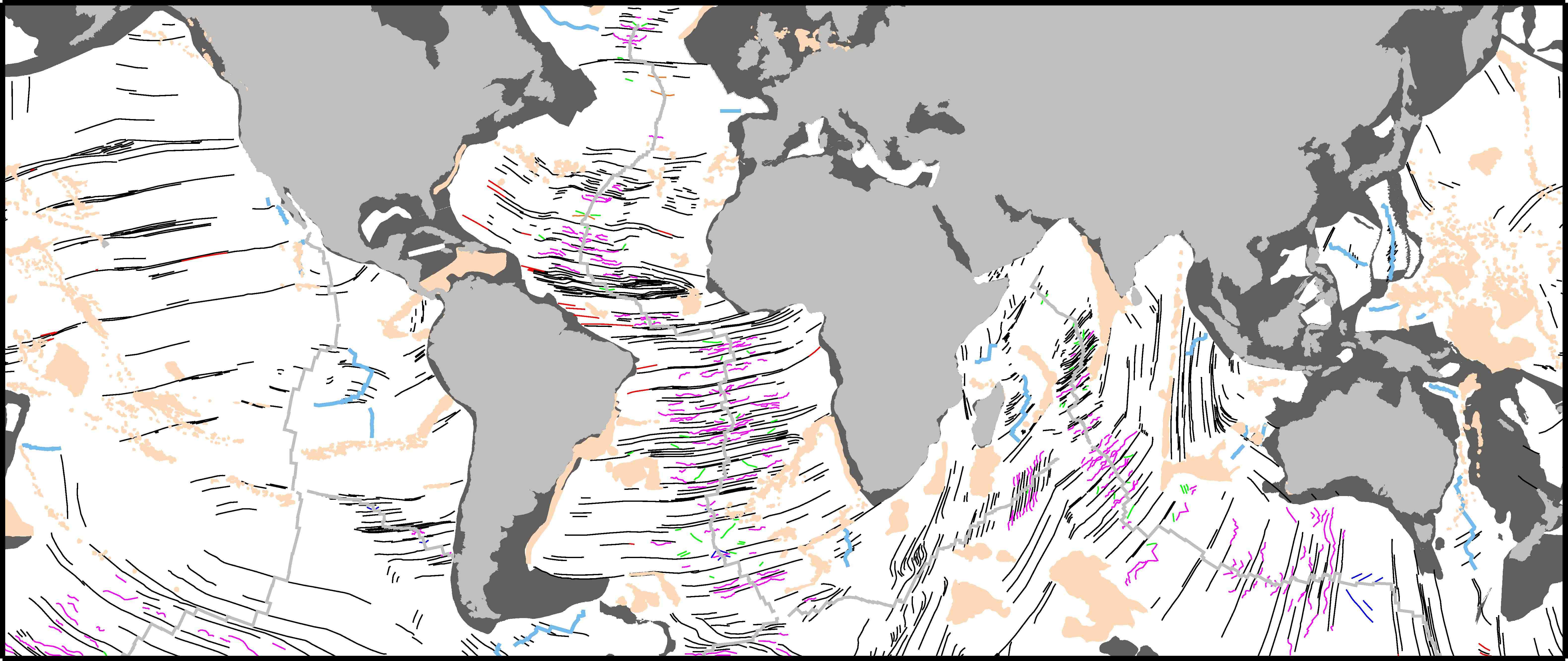 We present a global community data set of fracture zones (FZs), discordant zones, propagating ridges, V-shaped structures and extinct ridges, digitized from vertical gravity gradient (VGG) maps.
… Read more…
Journal of Geophysical Research – The tectonic fabric of the ocean basins
Matthews, K. J., Müller, R. D., Wessel, P., & Whittaker, J. M. (2011). The tectonic fabric of the ocean basins. Journal of Geophysical Research: Solid Earth (1978–2012), 116(B12). doi:10.1029/2011JB008413. Download the paper – pdf
Testing hotspot fixity in the Indian and Atlantic oceans
Project Summary
We have developed a novel interactive evolutionary inversion approach for computing absolute tectonic plate motions and their uncertainties based on hotspot tracks through time. We use a modified criterion of fit for inverting hotspot-track data, following an approach previously developed by Chang and co-workers for relative plate motions. Using this method, we derive covariance matrices for absolute plate rotations for the last 120 million years for the first time, using dated hotspot tracks in the Atlantic-Indian oceans. This represents a major advance in quantitatively constraining paleogeographic maps for the last 130 million years. … Read more…
EarthByte to attend AGU 2011
EarthByte group members Dietmar Müller, Adriana Dutkiewicz, Nicolas Flament, Leonardo Quevedo, Maria Seton, Simon Williams, Nathaniel Butterworth, Kayla Maloney and Kara Matthews are attending the AGU Fall Meeting 2011 in San Francisco, USA from 5-9 December, 2011. Click here for more details about the AGU Fall Meeting
Geomagnetism
Project Summary Derivation of Earth’s magnetic field as measured at satellite altitude and implications for Earth evolution, resource exploration, and environmental studies. Funding Agency World University Network for Geomagnetism Project Participants Prof David Gubbins Prof Dietmar Müller Dr David Ivers Prof Denis Winch Related Projects Virtual Geological Observatory Gondwanaland Evolution
Earth’s magnetic field
Project Summary
The magnetic field measured by satellites has 3 distinct sources: the dynamo in the liquid core, magnetised rocks near the Earth’s surface, and the external, solar terrestrial environment. It is difficult to separate out the large-scale field (originates in the earth’s core) from the small-scale, permanent field (originates in the earth’s crust). This project aims to develop physical theories for the origin of each field to aid separation, accompanied by comparison with satellite data and iterative improvements. It is envisaged that this project will extend our knowledge of the core field to unprecedented fine resolution while establishing the larger scales of the crustal field. … Read more…
Earth's magnetic field
Project Summary
The magnetic field measured by satellites has 3 distinct sources: the dynamo in the liquid core, magnetised rocks near the Earth’s surface, and the external, solar terrestrial environment. It is difficult to separate out the large-scale field (originates in the earth’s core) from the small-scale, permanent field (originates in the earth’s crust). This project aims to develop physical theories for the origin of each field to aid separation, accompanied by comparison with satellite data and iterative improvements. It is envisaged that this project will extend our knowledge of the core field to unprecedented fine resolution while establishing the larger scales of the crustal field. … Read more…
The global fracture zone and magnetic lineation data base project
Project Summary
Plate kinematic models derive from the detailed identifications of conjugate magnetic isochron picks and fracture zones (FZ). These data form the foundation of all relative marine plate tectonic reconstructions and codify our understanding of Earth’s surface evolution since the Mesozoic. Furthermore, FZ traces have extensive uses in many other marine geophysical investigations such as studying the origins of transform fault offsets, identifying seamounts and isolating abyssal hill roughness within fracture zone provinces, examining predictions from competing thermal models of the lithosphere, and much more. Kinematic models also require temporal information and this dimension is provided by identification of key magnetic isochron boundaries from total field magnetic anomalies collected along ship tracks. … Read more…
Planet scale reorganisations of the plate-mantle system
Project Summary
Global climate change and shrinking resources have heightened our sense of dependence on the earth as a dynamic and complex system. This project aims to provide a unifying context for enhancing our understanding and appreciation of the workings of the inner earth and, in particular, its complex system behaviour during major tectonic events. … Read more…
Nature Geoscience – Origin of Indian Ocean Seamount Province by shallow recycling of continental lithosphere
Hoernle, K., Hauff, F., Werner, R., van den Bogaard, P., Gibbons, A. D., Conrad, S., & Müller, R. D. (2011). Origin of Indian Ocean Seamount Province by shallow recycling of continental lithosphere. Nature Geoscience, 4(12), 883-887. doi:10.1038/ngeo1331. Download the paper – link
Indian Ocean cocktail party leaves trail of party hats behind
Ana Gibbons, Dietmar Müller and colleagues from IfM-GEOMAR Leibniz Institute of Marine Sciences, Germany research into Indian Ocean Cocktail Party leaves trail of party hats behind has been highlighted on the USyd News page. See the USyd News article ‘Indian Ocean Cocktail Party leaves trail of party hats behind’ here
DICTA – A spatio-temporal knowledge-discovery platform for Earth-Science data
Landgrebe, T. C. W., & Muller, R. D. (2011, December). A Spatio-Temporal Knowledge-Discovery Platform for Earth-Science Data, Digital Image Computing Techniques and Applications (DICTA). In 2011 International Conference on (pp. 6-8). doi:10.1109/DICTA.2011.73. Download the paper – pdf
Lithosphere – Mantle dynamics of continent-wide Cenzoic subsidence and tilting of Australia
DiCaprio, L., Gurnis, M., Müller, R. D., & Tan, E. (2011). Mantle dynamics of continentwide Cenozoic subsidence and tilting of Australia. Lithosphere, 3(5), 311-316. doi: 10.1130/L140.1. Download the paper – pdf