High horizontal fault displacement rates and landscape evolution

High horizontal fault displacement rates and landscape evolution video featured image

In this numerical model of landscape evolution we impose over 2 million of years deformation produced with the Underworld software over an initial flat surface, ie a 256 km square box at a resolution of 1 km. On top of the deformed surface, a landscape evolution model, Badlands, is used to simulate both hillslope and … Read more…

Virtual seafloor geology globe spinning North-South

Lithology globe Aus Ant view

This spinning virtual seafloor geology globe is composed of a set of screen captures of an interactive digital globe portraying the distribution of different seafloor sediments available at the Gplates Portal.Citation Dutkiewicz, A., Müller, R. D., O’Callaghan, S., & Jónasson, H. (2015). Census of seafloor sediments in the world’s ocean. Geology, G36883-1. doi: 10.1130/G36883.1.Download paper … Read more…

Virtual seafloor geology globe spinning East-West

Lithology globe Aus Ant view

This spinning virtual seafloor geology globe is composed of a set of screen captures of an interactive digital globe portraying the distribution of different seafloor sediments available at the Gplates Portal.Citation Dutkiewicz, A., Müller, R. D., O’Callaghan, S., & Jónasson, H. (2015). Census of seafloor sediments in the world’s ocean. Geology, G36883-1. doi: 10.1130/G36883.1.Download paper … Read more…

Big data reveals geology of world’s ocean floor

Lithology globe Aus Ant view

Lithology globe Aus Ant view
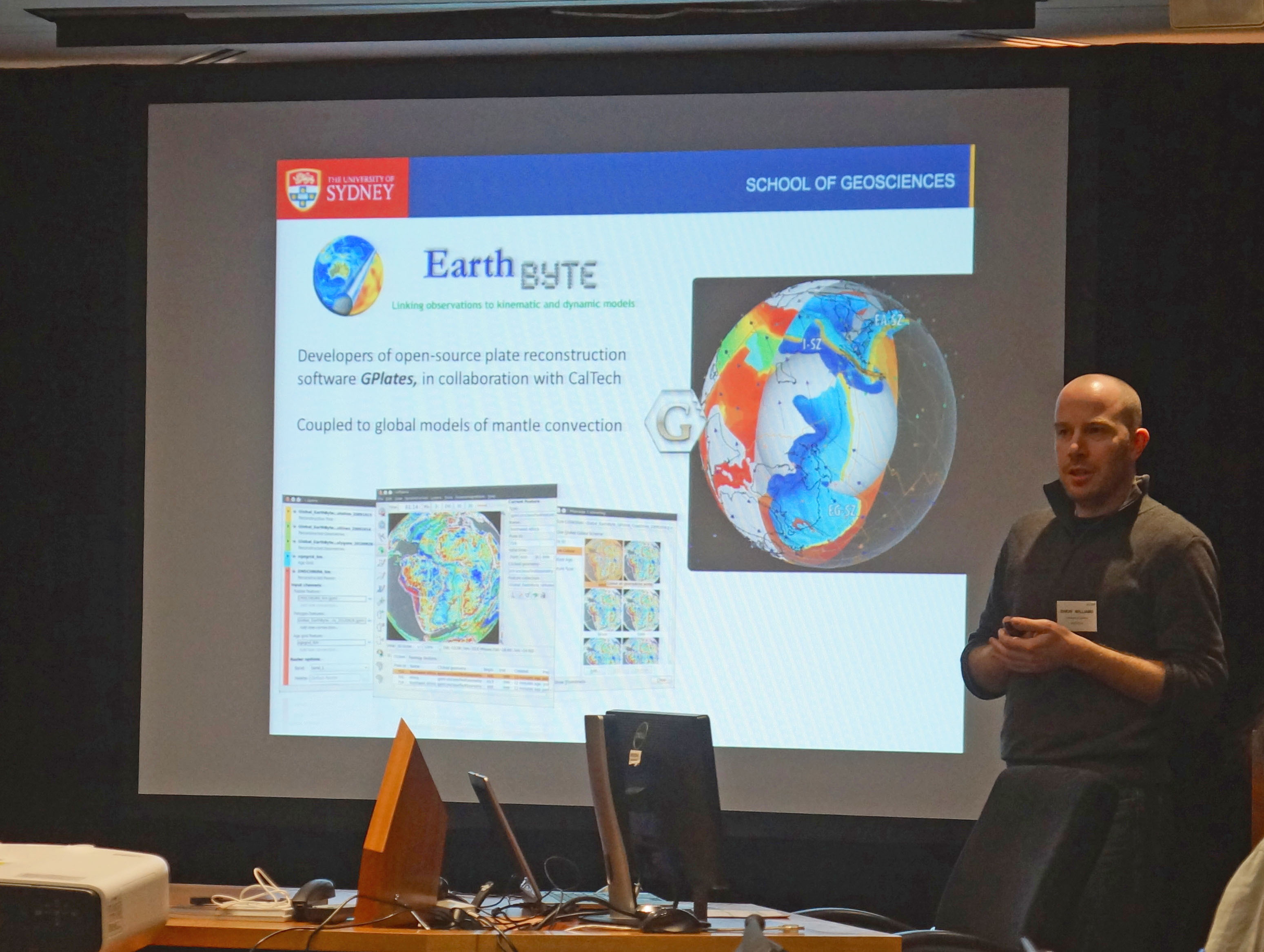
A team led by the University of Sydney School of Geosciences has created the first digital globe of seafloor sediments.

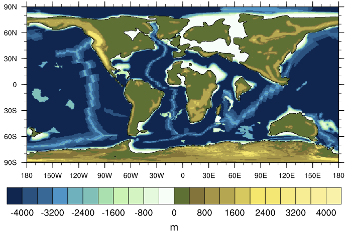
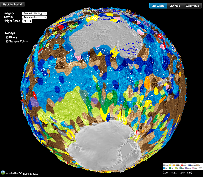
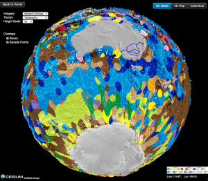
Ocean sediments cover 70% of our planet’s surface, forming the substrate for the largest ecosystem on Earth and its largest carbon reservoir – but the most recent map of seafloor geology was drawn by hand over 40 years ago, at the dawn of modern ocean exploration.

That’s about to change. In a gargantuan effort Adriana Dutkiewicz and her colleagues carefully analysed and categorised 15,000 seafloor sediment samples to reveal the nature of sedimentary blankets over ocean ridges, seamounts and the vast abyssal plains. She teamed up with big data experts to find the best way to use modern computer algorithms to turn the vast sea of point observations into a continuous digital map.  … Read more…

Share

Northwest Shelf in the media

An upcoming IODP expedition along the WA coast led by Prof Stephen Gallagher has received significant media attention. The two month expedition will be drilling into the seabed in order to examine the climatic conditions of the North West continental shelf over the past five million years.

Read more…

Share

Big Data Knowledge Discovery

Big Data Knowledge Discovery is an interdisciplinary research initiative that focuses on the scientific challenges and opportunities presented by the use of the new techniques of data science applied in the natural sciences. This research initiative brings together world class discipline leaders in the data-intensive sciences of Geo Sciences, Life Sciences and Physical Sciences with … Read more…

EarthByte participates in Gondwana Map Project workshop in Rio de Janeiro

Nicholas Barnett-Moore with the Gondwana Map Project team in Rio de Janeiro

Nicholas Barnett-Moore speaking at the Gondwana Map Project workshop in Rio de JaneiroRecently the EarthByte group was invited to participate in the two-week long ‘Rio Gondwana Workshop’, in Rio de Janeiro (22nd June – 3rd July), that focused on the development of a new Gondwana geology map. This is part of the IGCP Project 628 – The Gondwana Map Project. The collaborators involved in this project were very interested in incorporating GPlates into their workflow for developing the Gondwana geological map.

PhD candidate Nicholas Barnett-Moore represented the EarthByte Group. He participated in a week-long discussion on the efforts and new thinking required to develop a new geological map(s) of Gondwana. … Read more…

Share

Big Data Maps World’s Ocean Floor

Lithology globe Aus Ant viewScientists from the University of Sydney’s School of Geosciences have led the creation of the world’s first digital map of the seafloor’s geology.

It is the first time the composition of the seafloor, covering 70 percent of the Earth’s surface, has been mapped in 40 years; the most recent map was hand drawn in the 1970s.

Published in the latest edition of Geology, the map will help scientists better understand how our oceans have responded, and will respond, to environmental change. It also reveals the deep ocean basins to be much more complex than previously thought.

Read more…

Share

Nature – Onset of Antarctic Circumpolar Current 30 million years ago as Tasmanian Gateway aligned with westerlies

Simon Williams on the Southern Surveyor

Scher, H. D., Whittaker, J. M., Williams, S. E., Latimer, J. C., Kordesch, W, E, C., & Delaney, M, L. (2015). Onset of Antarctic Circumpolar Current 30 million years ago as Tasmanian Gateway aligned with westerlies. Nature, 523, 580-583.

Onset of Antarctic Circumpolar Current 30 million years ago as Tasmanian Gateway aligned with westerlies

Congratulations to Simon Williams and Tassie EarthByter Joanne Whittaker for co-authoring the paper in Nature.

In a project led by Howie Scher from the University of South Carolina they used fossil fish teeth recovered from the oceans around Australia combined with detailed tectonic reconstructions to shed new light on the origins of the world’s mightiest ocean current, … Read more…

Share

India – Eurasia collision paper makes "Most Downloaded" list

Sabin Zahirovic Magic Planet

Congratulations to Dr Ana Gibbons, Dr Sabin Zahirovic, Dr Joanne Whittaker and Dr Yatheesh Vadakkeyakath, whose paper “A tectonic model reconciling evidence for the collisions between India, Eurasia and intra-oceanic arcs of the central-eastern Tethys” is now the third-most downloaded paper on Gondwana Research over the last 90 days!

Most Downloaded Gondwana Research Articles

The paper already has 3 citations (not bad for a paper that just came out this month).

Citation
Gibbons, A. D., Zahirovic, S., Müller, R. D., Whittaker, J. M., & Yatheesh, V. (2015). A tectonic model reconciling evidence for the collisions between India, Eurasia and intra-oceanic arcs of the central-eastern Tethys. Gondwana Research. doi: 10.1016/j.gr.2015.01.001.

Read more…

Share

India – Eurasia collision paper makes “Most Downloaded” list

Sabin Zahirovic Magic Planet

Congratulations to Dr Ana Gibbons, Dr Sabin Zahirovic, Dr Joanne Whittaker and Dr Yatheesh Vadakkeyakath, whose paper “A tectonic model reconciling evidence for the collisions between India, Eurasia and intra-oceanic arcs of the central-eastern Tethys” is now the third-most downloaded paper on Gondwana Research over the last 90 days!

Most Downloaded Gondwana Research Articles

The paper already has 3 citations (not bad for a paper that just came out this month).

Citation
Gibbons, A. D., Zahirovic, S., Müller, R. D., Whittaker, J. M., & Yatheesh, V. (2015). A tectonic model reconciling evidence for the collisions between India, Eurasia and intra-oceanic arcs of the central-eastern Tethys. Gondwana Research. doi: 10.1016/j.gr.2015.01.001.

Read more…

Share

Earth's climate throughout the Phanerozoic

Eocene topo bath

Eocene topo bathProject Summary
EarthByte is involved in a series of projects aimed at understanding and modeling Earth’s climate throughout the Phanerozoic. Some of these projects include:

  • Future Fellowship of Maria Seton on “Oceanic gateways: a primary control on global climate change?”
  • Basin GENESIS Hub activities, related to the effect of the mantle, crustal deformation, erosion and sedimentary processes on sedimentary basins
  • ATOM – a coupled atmospheric-ocean circulation code jointly developed by Prof. Roger Grundmann and EarthByte.

EarthByte’s expertise in tectonics, geodynamics and surface process modeling is enhanced by close collaborations with leading palaeoclimate modellers and geochemical oceanographers.  … Read more…

Share

Earth’s climate throughout the Phanerozoic

Eocene topo bath

Eocene topo bathProject Summary
EarthByte is involved in a series of projects aimed at understanding and modeling Earth’s climate throughout the Phanerozoic. Some of these projects include:

  • Future Fellowship of Maria Seton on “Oceanic gateways: a primary control on global climate change?”
  • Basin GENESIS Hub activities, related to the effect of the mantle, crustal deformation, erosion and sedimentary processes on sedimentary basins
  • ATOM – a coupled atmospheric-ocean circulation code jointly developed by Prof. Roger Grundmann and EarthByte.

EarthByte’s expertise in tectonics, geodynamics and surface process modeling is enhanced by close collaborations with leading palaeoclimate modellers and geochemical oceanographers.  … Read more…

Share

Gondwana Research – The tectonic stress field evolution of India since the Oligocene

Dietmar Müller

Müller, R. D., Yatheesh, V., & Shuhail, M. (2014). The tectonic stress field evolution of India since the Oligocene. Gondwana Research. doi:10.1016/j.gr.2014.05.008. The tectonic stress field evolution of India since the Oligocene Download accompanying data – zip file

EarthByte's plate tectonic animation added to NOAA's SOS database

An EarthByte plate tectonic animation has recently been added to NOAA’s Science on a Sphere database. NOAA produces large interactive 3D spherical projection systems that are installed at museums, universities, schools and other institutes across the world (see Science On a Sphere map locations). The EarthByte animation is from the recent Gibbons et al. (2015) … Read more…

EarthByte’s plate tectonic animation added to NOAA’s SOS database

An EarthByte plate tectonic animation has recently been added to NOAA’s Science on a Sphere database. NOAA produces large interactive 3D spherical projection systems that are installed at museums, universities, schools and other institutes across the world (see Science On a Sphere map locations). The EarthByte animation is from the recent Gibbons et al. (2015) … Read more…

Summer Scholarship opportunities available within the School of Geosciences

The Division of Natural Sciences at the University of Sydney offers a variety of Summer Scholarship opportunities for students in the 2nd or 3rd year of their undergraduate degree.

Research projects are available in most disciplines for a duration of between 4-6 weeks over the Summer holiday period (November-February).

The program is open to both current University of Sydney students as well as students from other Australian Universities. Each scholarship is valued at $497 (in accordance with APA rate) per week for the duration of the project.  … Read more…

Share

EarthByte welcomes Nicolas Coltice and Claire Mallard

This week we’re excited to host our long-term collaborators from France, Prof Nicolas Coltice and PhD student Claire Mallard. They will be presenting their work as part of the Augury Project – a European Research Council funded initiative to study the Earth’s evolution of mantle convection and plate tectonics. They spent two weeks field mapping in … Read more…

EarthByte helps the International Science School

Nikita and Jono at the International Science SchoolEarthByte helped run the 2015 geosciences workshop for the University of Sydney’s International Science School, with over 140 high school students engaging in activities from a wide range of research topics and teaching areas at the School of Geosciences. Thanks to all the brilliant EarthByte volunteers, including Mandi Thran, Nikita Golkin, Luke Hardiman, Jono Leonard and Carmen Braz.


See the School of Geoscience’s Facebook page for more info and photos from the day!  … Read more…

Share

Gondwana Research – A tectonic model reconciling evidence for the collision between India, Eurasia and intra-oceanic arcs of the central-eastern Tethys

Gibbons, A. D., Zahirovic, S., Müller, R. D., Whittaker, J. M., & Yatheesh, V. (2015). A tectonic model reconciling evidence for the collisions between India, Eurasia and intra-oceanic arcs of the central-eastern Tethys. Gondwana Research. doi: 10.1016/j.gr.2015.01.001. A tectonic model reconciling evidence for the collisions between India, Eurasia and intra-oceanic arcs of the central-eastern Tethys

EarthByte joins ACTER

Simon Williams' ACTER talk photoRecently, EarthByte joined the Australia-China Joint Research Centre for Tectonics and Earth Resources (ACTER). The joint research centre is led by the Institute for Geoscience Research at Curtin University and the Institute of Geology and Geophysics of the Chinese Academy of Sciences, with involvement of Australian and Chinese universities and industry partners. The aim of the centre is to promote joint research activities, the exchange of staff and students, and to foster long-term mutually-beneficial collaboration between Australian and Chinese research groups. … Read more…

Share

Geochemistry, Geophysics, Geosystems – Semi-automatic fracture zone tracking

Wessel, P., Matthews, K. J., Müller, R. D., Mazzoni, A., Whittaker, J. M., Myhill, R., & Chandler, M. T. (2015). Semi-automatic fracture zone tracking. Geochemistry, Geophysics, Geosystems. doi: 10.1002/2015GC005853. Semi-automatic fracture zone tracking This paper includes an update to the global seafloor tectonic fabric data set by Matthews et al. (JGR, 2011).  Based on the vertical gravity … Read more…