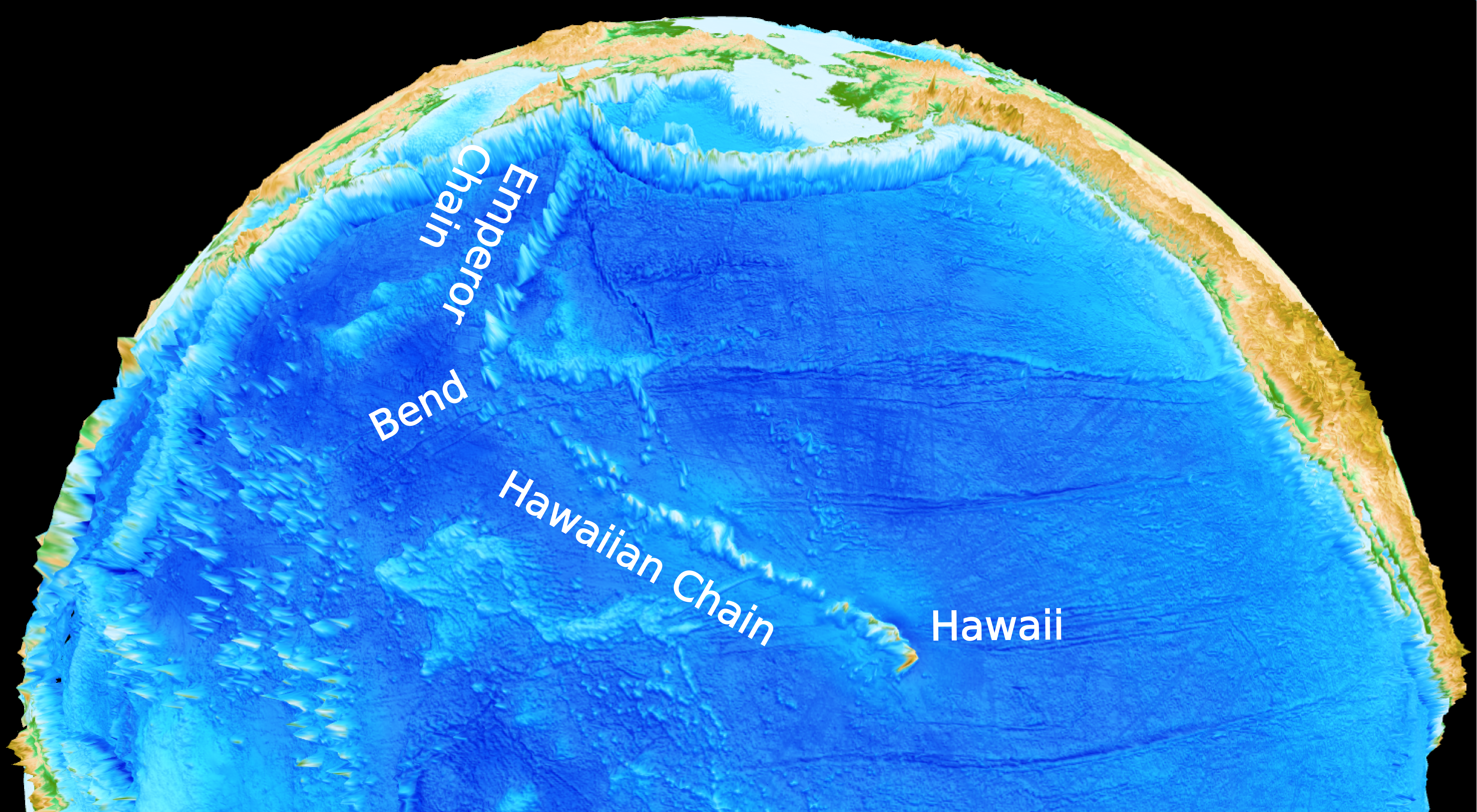
 In a paper published in Nature, Rakib Hassan with fellow EarthByters Dietmar Müller, Simon E. Williams & Nicolas Flament, and Caltech’s Michael Gurnis, proposed a solution to a long standing geological mystery – how the distinct bend in the Hawaiian-Emperor Seamount Chain came to be. Using NCI’s Raijin supercomputer, the research team simulated flow patterns in the Earth’s mantle over the past 100 million years. The convection model suggests that the history of subduction has a profound effect on the time-dependent deformation of the edges of the Large Low-Shear Velocity Province (LLSVP) under the Pacific. The Hawaiian plume originates from the edge of this province and the southward migration of the plume during the formation of the Emperor chain reflects the migration of the northern edge of the LLSVP before ~47 million years ago.
… Read more…
Media
See below for all the latest EarthByte news items and media releases that have picked up media attention. See Media Archive for a breakdown by year.

Geologists Discover How Australia’s Highest Mountain Formed
 Congratulations to Prof Dietmar Müller, Dr Nicolas Flament, Dr Kara Matthews, Dr Simon Williams, and Prof Michael Gurnis on their paper recently published in Earth and Planetary Science Letters. Their paper, Formation of Australian continental margin highlands driven by plate-mantle interaction, has featured in a variety of Australian and international media outlets.
Geologists Discover How Australia’s Highest Mountain Formed – Media Release
Geologists from the University of Sydney and the California Institute of Technology have solved the mystery of how Australia’s highest mountain – Mount Kosciusko – and surrounding alps came to exist.
Most of the world’s mountain belts are the result of two continents colliding (including the Himalayas) or volcanism. The mountains of Australia’s Eastern highlands – stretching from north-eastern Queensland to western Victoria – are an exception. Until now no one knew how they formed.
GPlates Portal International Media Coverage
 The recent article on the GPlates Portal published in PLOS ONE by Prof Dietmar Müller, Xiaodong Qin, Prof David Sandwell, Dr Adriana Dutkiewicz, Dr Simon Williams, Dr Nicolas Flament, Dr Stefan Maus, and Dr Maria Seton, has received significant international media attention over the past week, featuring in articles from Australia, UK, US, India, and UAE!
See the list of online media below, and check out the interactive globes yourself!
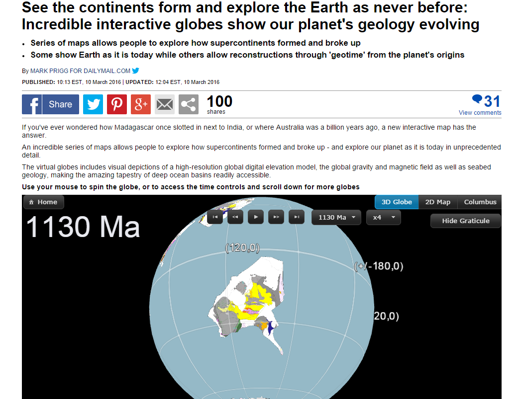
Virtual Time Machine Of Earth’s Geology Now In The Cloud
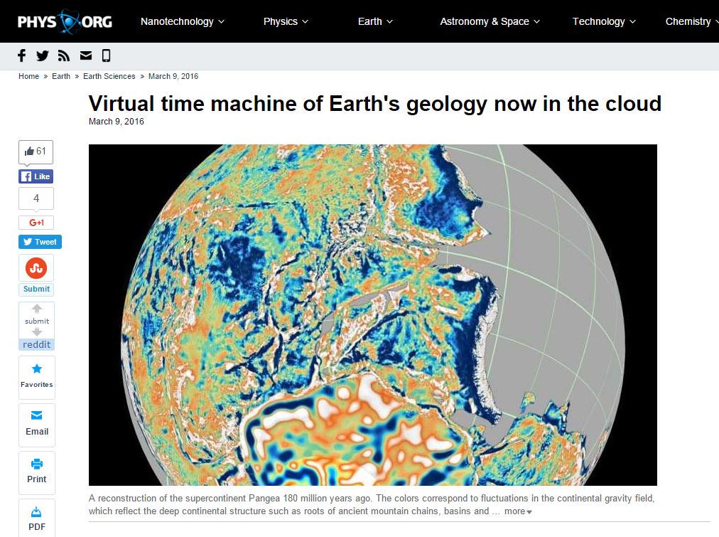
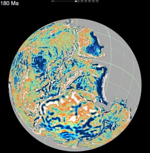
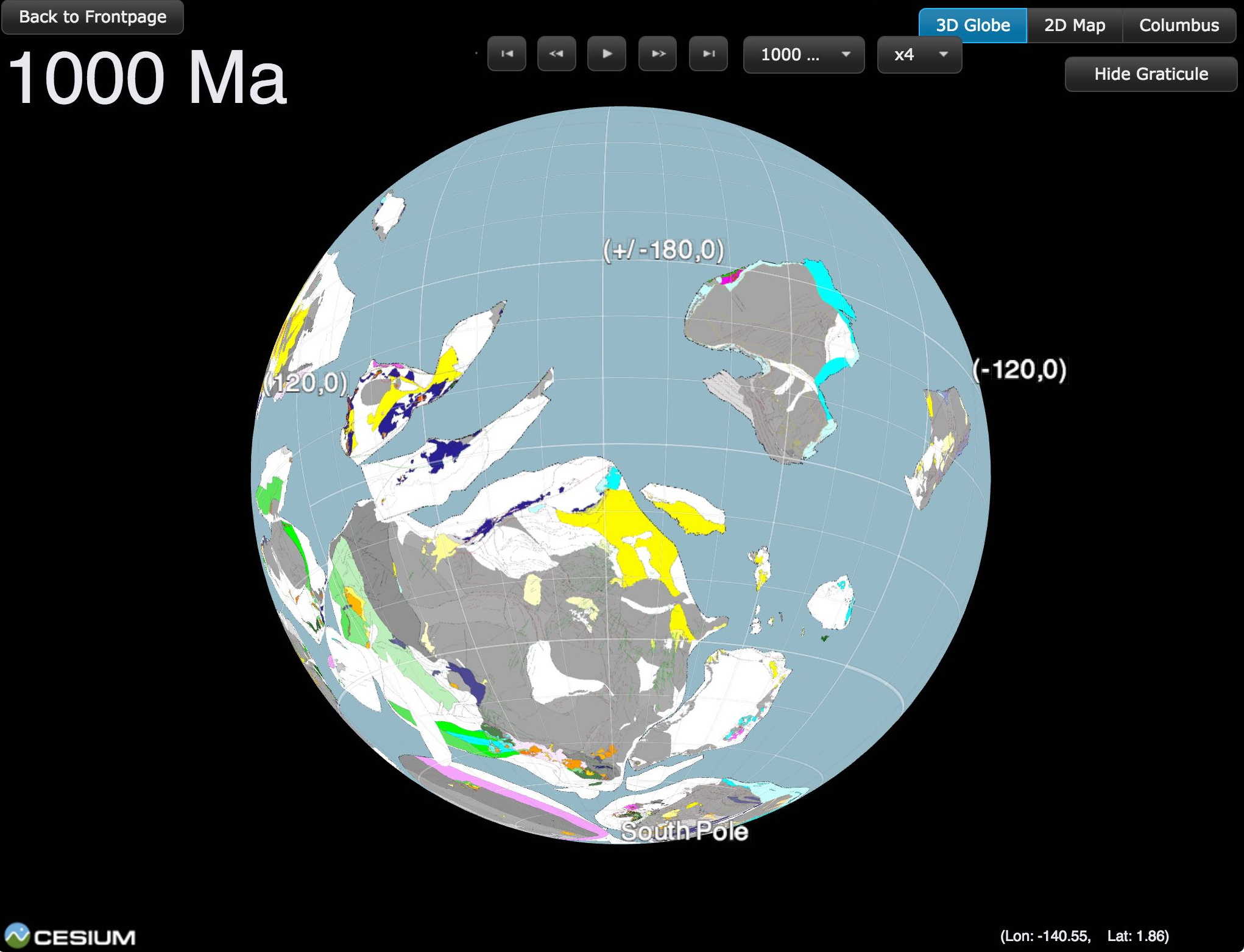
How did Madagascar once slot next to India? Where was Australia a billion years ago?
Cloud-based virtual globes developed by a team led by University of Sydney geologists mean anyone with a smartphone, laptop or computer can now visualise, with unprecedented speed and ease of use, how the Earth evolved geologically.
Reported today in PLOS ONE, the globes have been gradually made available since September 2014. Some show Earth as it is today while others allow reconstructions through ‘geological time’, harking back to the planet’s origins.
Uniquely, the portal allows an interactive exploration of supercontinents. It shows the breakup and dispersal of Pangea over the last 200 million years. It also offers a visualisation of the supercontinent Rodinia, which existed 1.1 billion years ago. Rodinia gradually fragmented, with some continents colliding again more than 500 million years later to form Gondwanaland.
GPlates in Spanish news
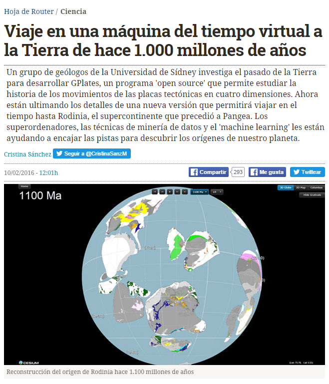
The link below points to an article written about EarthByte and GPlates by a Spanish journalist. The article is titled: “Viaje en una máquina del tiempo virtual a la Tierra de hace 1.000 millones de años: … which translates into: Travel in a virtual time machine to Earth 1,000 million years ago. http://m.eldiario.es/hojaderouter/ciencia/gplates-pangea-geologia-historia-Tierra-big_data_0_482951817.html Buenos dias todos … Read more…
EarthByte/Scripps research features on NASA Earth Observatory
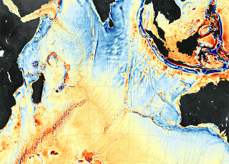
NASA Earth Observatory features a piece on the recent Mammerickx Microplate discovery. Their Image of the Day for 13 January 2016 is a satellite gravity map of the Indian Ocean, and the associated article, entitled ‘New Seafloor Map Helps Scientists Find New Features‘, discusses the power of satellite data for seafloor mapping and details the … Read more…
Incredibly detailed, billion-year-old ancient maps of Earth produced by researchers
An article discussing GPlates and research that EarthByte is involved in has been featured on the IFL Science! website entitled ‘Incredibly Detailed, Billion-Year-Old Ancient Maps Of Earth Produced By Researchers‘.
History and current advances in reconstructing the Earth through deep geological time
Time machine: History and current advances in reconstructing the Earth through deep geological time – an article on Quartz by Steve LeVine. The article is a review of the development of ideas and technologies in reconstructing the Earth through deep time, aimed at understanding supercontinent assembly, breakup and dispersal, starting with Alfred Wegener. The article focusses on research activities in the context of the IGCP 648 project ‘Supercontinent Cycles and Global Geodynamics‘ led by Zheng-Xiang Li. The piece provides some historical context, and highlights the work of a number of leading scientists, postdoctoral researchers and PhD students currently involved in this work. … Read more…
Mammerickx Microplate media coverage
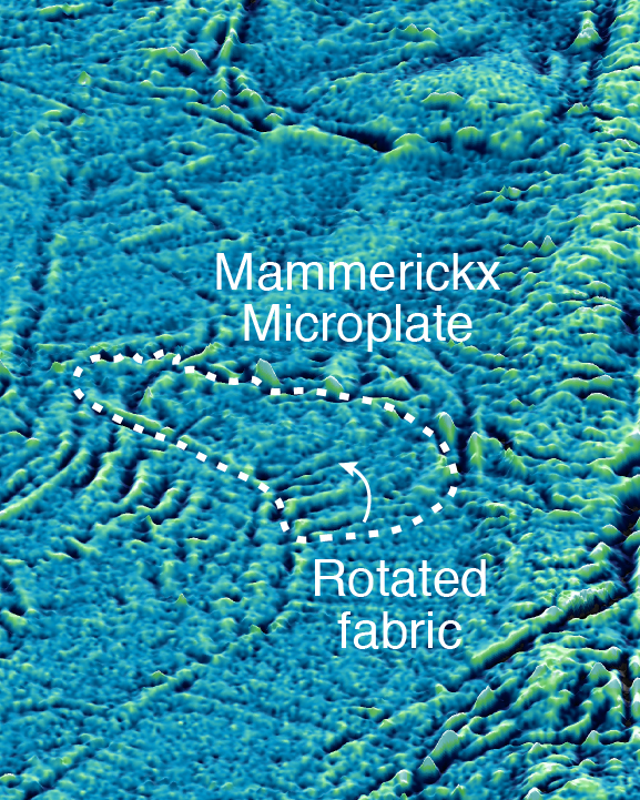
The recent EPSL article on the discovery of the Mammerickx Microplate, by Dr Kara Matthews, Prof Dietmar Müller and Prof David Sandwell, has received lots of media attention from many different countries around the world including Australia, UK, USA, India, Pakistan, Mexico, Nepal and Honduras.
See below for a list of media items:
Online Media
The biggest continental collision in Earth’s history: Scientists pinpoint crashing together of continents that created the Himalayas 50 million years ago – Daily Mail
Scientists fix date for earth-shattering Himalayan birth pangs – The Sydney Morning Herald
Microplate discovery dates birth of Himalayas – EurekAlert!
Himalayas: Discovery of first ancient Indian Ocean microplate hints at new date of formation of mountain range – Yahoo! News … Read more…
Ancient Indian Ocean microplate discovery dates birth of Himalayas
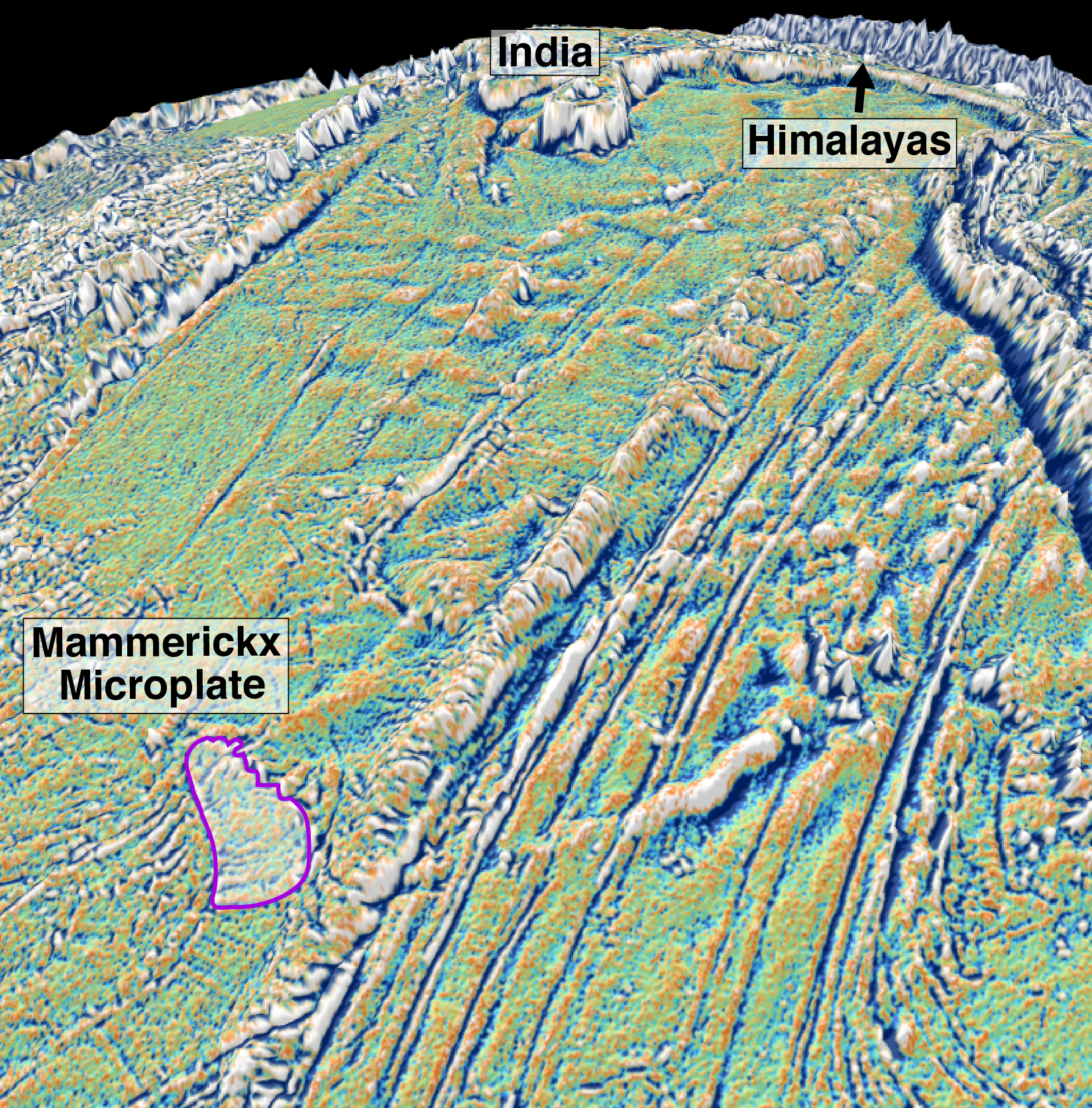
An international team of scientists led by the University of Sydney’s School of Geosciences has discovered that the crustal stresses caused by the initial collision between India and Eurasia cracked the Antarctic Plate far away from the collisional zone and broke off a fragment the size of Tasmania in a remote patch of the central Indian Ocean.
The ongoing tectonic collision between the two continents produces enormous geological stresses that build up along the Himalayas and lead to numerous earthquakes every year – but now scientists have unravelled how stressed the Indian Plate became 47 million years ago when its northern edge first collided with Eurasia. … Read more…
Opening speech, ARC Research Hub for Basin GEodyNamics and Evolution of SedImentary Systems
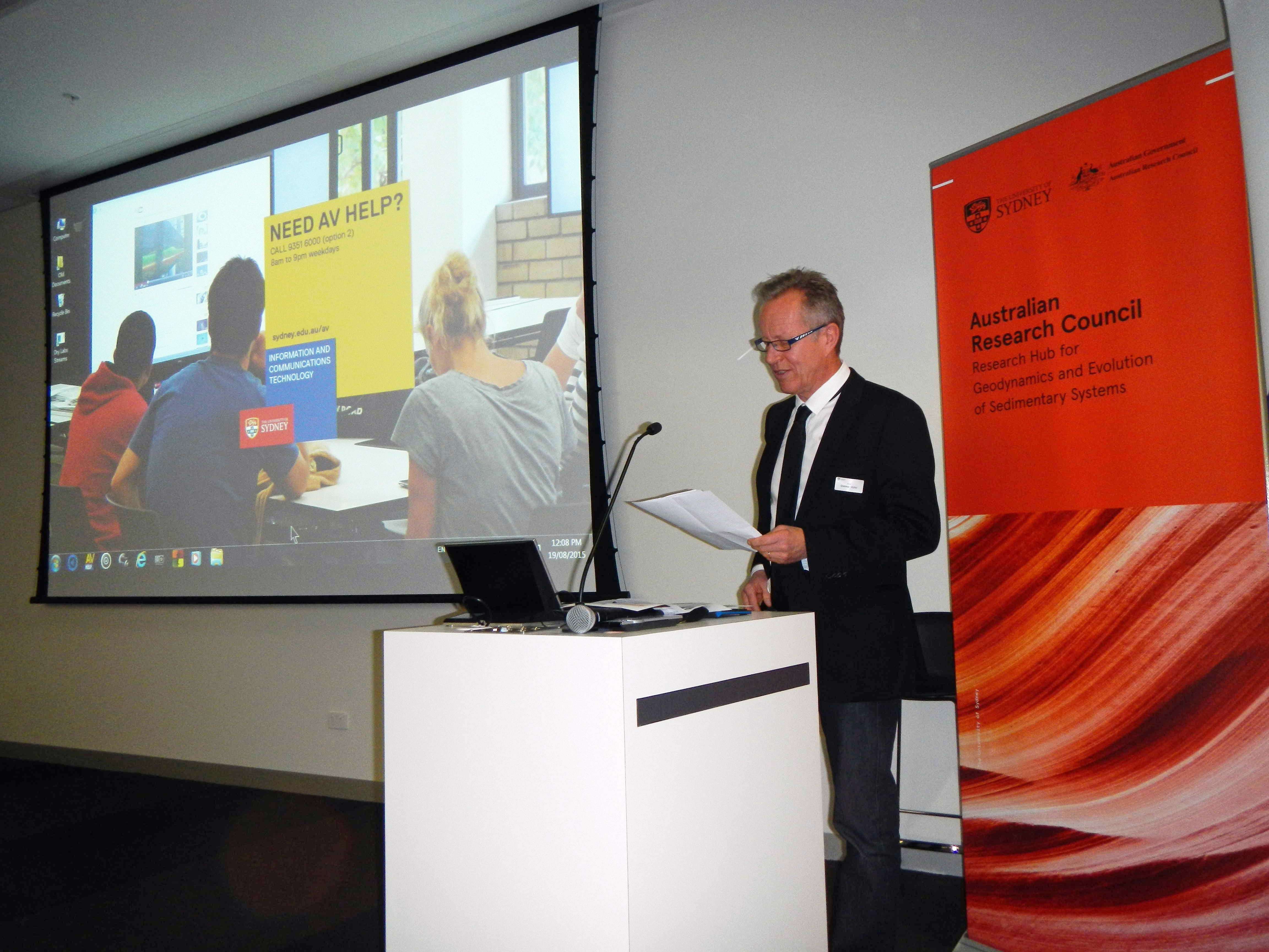
 Prof Dietmar Müller, Wed 19 August 2015
Good afternoon! On behalf of the University of Sydney and the School of Geosciences I welcome you to the opening of the ARC Research Hub for Basin GEodyNamics and Evolution of SedImentary Systems (in short Basin Genesis Hub).
Before we begin the proceedings, I would like to acknowledge and pay respect to the traditional owners of the land on which we meet – the Gadigal people of the Eora Nation. It is upon their ancestral lands that the University of Sydney is built.
I would like to extend a special thank you to our industry partners, Statoil, Chevron, Oil Search, Intrepid Geophysics and 3D-GEO, many of whom are here today. We are especially pleased to have with us today Ms Leanne Harvey, Executive General Manager of the ARC. … Read more…
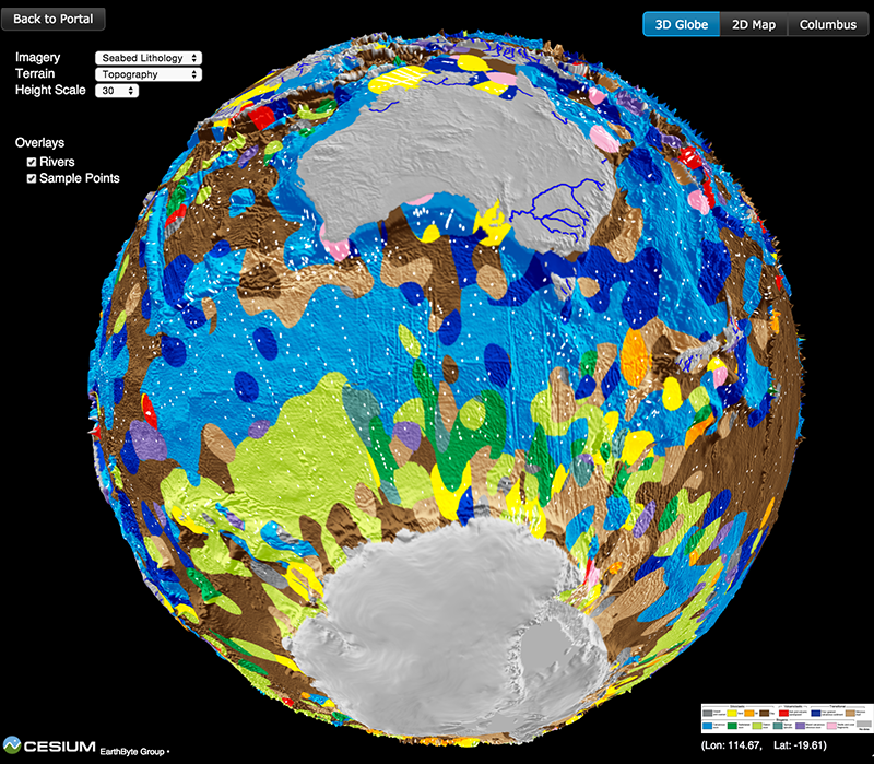
Ocean sediment map makes world news
 The recently-published ocean sediment map made by Dr Adriana Dutkiewicz and colleagues has taken the world’s media by storm. It’s been reported online and in press, from Australia to Cuba, Hungary and many other countries! See the updated list of media items below, and check out the link to the interactive 3D globe with the ocean sediments map.
Countries where the story has been covered so far:
Australia, UK, USA, India, Italy, Germany, Spain, Hungary, Austria, Cuba, Costa Rica and Peru.
Radio Interviews
ABC 774 Melbourne
World’s first digital seafloor map reveals ‘paradise’ – ABC Rural Radio
ABC 702 Sydney
BBC Radio 5 Live’s “Up All Night”
It took more than a year of research and sifting through thousands of samples to generate the world’s first digital map of the seafloor – ABC Country Radio (Interview at 41:10) … Read more…
Big data reveals geology of world’s ocean floor
A team led by the University of Sydney School of Geosciences has created the first digital globe of seafloor sediments.
Ocean sediments cover 70% of our planet’s surface, forming the substrate for the largest ecosystem on Earth and its largest carbon reservoir – but the most recent map of seafloor geology was drawn by hand over 40 years ago, at the dawn of modern ocean exploration.
That’s about to change. In a gargantuan effort Adriana Dutkiewicz and her colleagues carefully analysed and categorised 15,000 seafloor sediment samples to reveal the nature of sedimentary blankets over ocean ridges, seamounts and the vast abyssal plains. She teamed up with big data experts to find the best way to use modern computer algorithms to turn the vast sea of point observations into a continuous digital map. … Read more…
NICTA and University of Sydney creates world first digital map of seafloor geology
New digital seafloor geology map uses artificial intelligence and big data to boost understanding of the ocean floor
A collaboration between National ICT Australia (NICTA) and the University of Sydney School of Geosciences has created the first digital map of seafloor sediments.
Big Data Maps World’s Ocean Floor
Scientists from the University of Sydney’s School of Geosciences have led the creation of the world’s first digital map of the seafloor’s geology.
It is the first time the composition of the seafloor, covering 70 percent of the Earth’s surface, has been mapped in 40 years; the most recent map was hand drawn in the 1970s.
Published in the latest edition of Geology, the map will help scientists better understand how our oceans have responded, and will respond, to environmental change. It also reveals the deep ocean basins to be much more complex than previously thought.
ScienceNews features an article on Pacific plate motions paper
EarthByte paper ‘Revision of Paleogene plate motions in the Pacific and implications for the Hawaiian-Emperor bend‘ is featured in ScienceNews with an article entitled ‘Plate loss gave chain of Pacific islands and seamounts a bend‘. Revision of Paleogene plate motions in the Pacific and implications for the Hawaiian-Emperor bend
Sabin Zahirovic features in Science Magazine
Congratulations to Sabin, who has made it to the News front page of the Science Magazine with a news article entitled ‘Earth’s tectonic plates skitter about‘ about a recently published paper in Earth and Planetary Science letters: Tectonic speed limits from plate kinematic reconstructions. Well done Sabin! Link to download the paper
Research voyage on RV Investigator funded for 2016
Dr Maria Seton and Dr Simon Williams from the School of Geosciences and colleagues from GNS Science and the Geological Survey of New Caledonia were awarded ship time on Australia’s new, state-of-the-art research vessel, the RV Investigator. The supplementary voyage, with Dr Seton as Chief Scientist, will investigate the continuity of Australian terranes into Zealandia … Read more…
EarthByte research for the mining industry attracts media attention
Insights from recent and ongoing research at EarthByte for the mining industry were highlighted in a recent edition of Australian Resources and Investment (Vol. 8, 4). Download the Australian Resources and Investment article here – pdf
The Basin GENESIS Hub
The ARC Research Hub for Basin Geo-dynamics and Evolution of Sedimentary Systems (Basin Genesis Hub, BGH) brings together a broad range of expertise for the development and application of cutting-edge numerical modelling tools with the aim of improving the understanding of the formation and evolution of basins. The coupling of the evolution of mantle flow, … Read more…
Nature – Spreading continents kick-started plate tectonics
Rey, P. F., Coltice, N., & Flament, N. (2014). Spreading continents kick-started plate tectonics. Nature, 513(7518), 405-408. doi: 10.1038/nature13728.
EarthByte Group makes the finals of the Eureka Prize
The EarthByte group is a finalist for the Eureka Prize from the Australian Museum, for its development of GPlates software! The prize is awarded annually for research innovation and GPlates was nominated for providing a “experimental virtual planet” to investigate geological systems through deep time. You can read more about the Eureka Prize here. Watch the … Read more…
Big Data Knowledge Discovery launch attracts publicity
The Big Data Knowledge Discovery launch was featured in a full-length article in the Newsletter of the Geological Society of Australia in March. Download the newsletter – pdf Visit Big Data Knowledge Discovery website.
EarthByte publicity for Oblique rifting of the Equatorial Atlantic paper
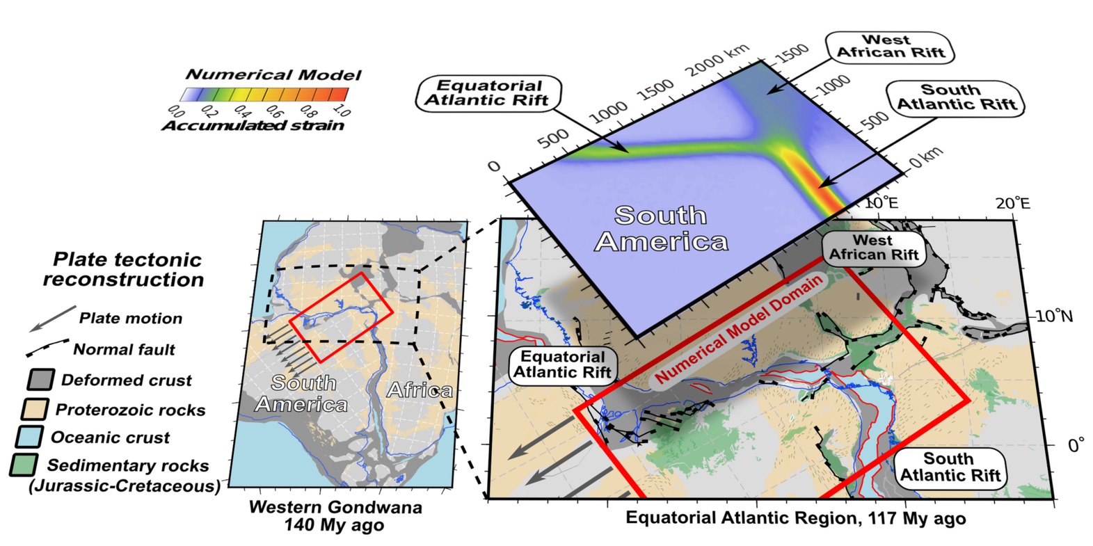 Congratulations to EarthByte’s Sascha Brune and Christian Heine (now at Shell in The Hague) who made it to the Sydney Uni front page with a media piece on “How the world missed out on a Saharan Atlantic ocean”, attracted international media attention and were chosen as a “Research Focus” in the current volume of Geology for their paper: Oblique rifting of the Equatorial Atlantic: Why there is no Saharan Atlantic Ocean. Well done! … Read more…
Patrice Rey interviewed as a ‘Man of Mars and Opals’!
Patrice Rey was interviewed for a Sydney Morning Herald MyCareer feature, as a ‘Man of Mars and Opals’! Download the article – pdf
Patrice Rey interviewed as a 'Man of Mars and Opals'!
Patrice Rey was interviewed for a Sydney Morning Herald MyCareer feature, as a ‘Man of Mars and Opals’! Download the article – pdf
GPlates finalist in The Australian Innovation Challenge 2013
EarthByte-developed GPlates software, represented by Prof Dietmar Müller, has been nominated for The Australian Innovation Challenge 2013 and it has become a finalist in the minerals and energy category! Read the article published in The Australian here
Opal exploration research recognised as outstanding highlight
Recent EarthByte research on opal exploration was recognised as an outstanding highlight and reflects the work of many of the group including, Andrew Merdith, Tom Landgrebe, Adriana Dutkiewicz and Patrice Rey. Congratulations to all of the contributors to the project and specifically to John Cannon and Michael Chin, the GPlates developers!
Big Data project and Earthbyte data mining research features on Australia Unlimited website
The Big Data project and Earthbyte data-mining research was publicised in the “Data mining for gold” story on the Australia unlimited website. The project is now part of “Brand Australia“. Read the article here