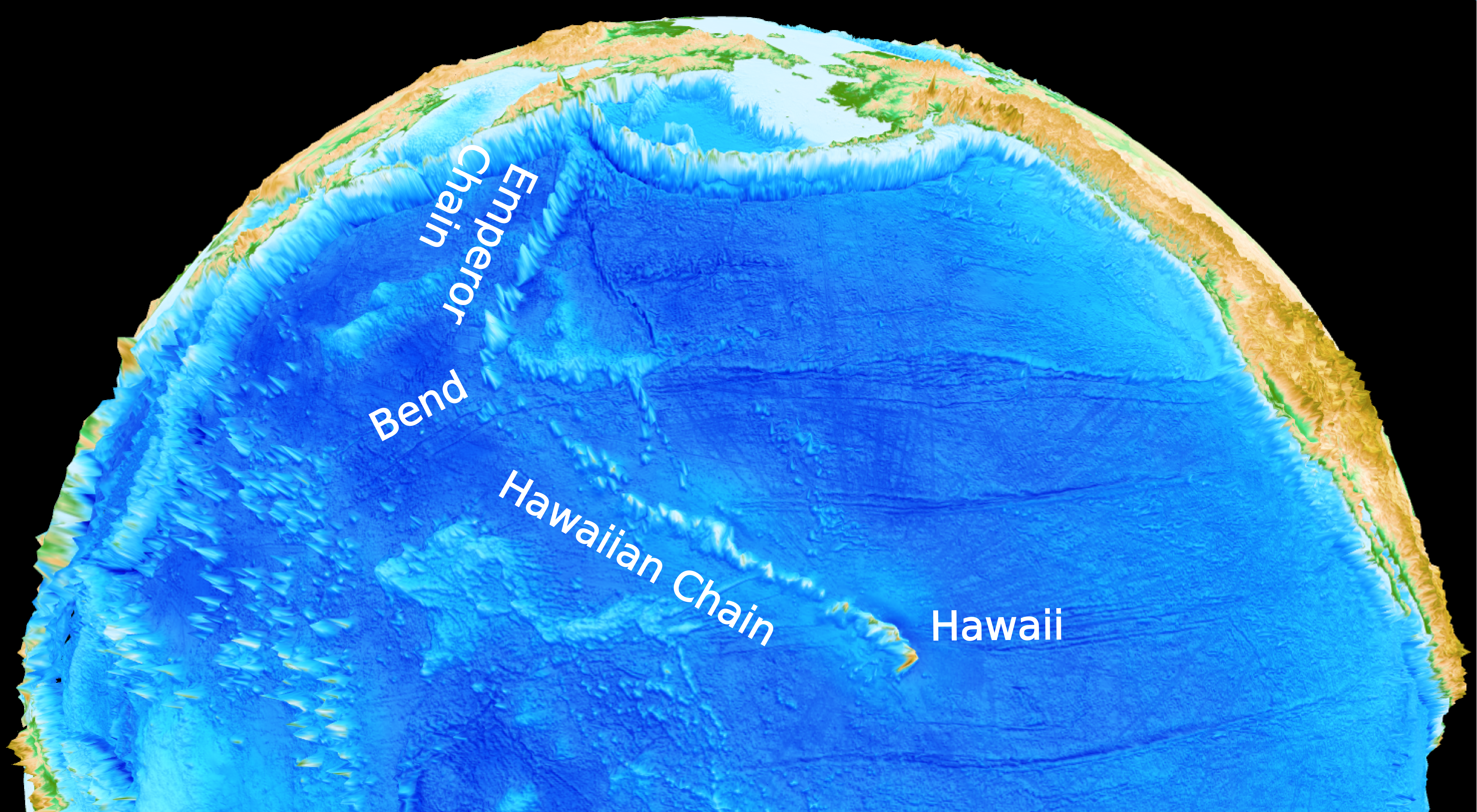
 In a paper published in Nature, Rakib Hassan with fellow EarthByters Dietmar Müller, Simon E. Williams & Nicolas Flament, and Caltech’s Michael Gurnis, proposed a solution to a long standing geological mystery – how the distinct bend in the Hawaiian-Emperor Seamount Chain came to be. Using NCI’s Raijin supercomputer, the research team simulated flow patterns in the Earth’s mantle over the past 100 million years. The convection model suggests that the history of subduction has a profound effect on the time-dependent deformation of the edges of the Large Low-Shear Velocity Province (LLSVP) under the Pacific. The Hawaiian plume originates from the edge of this province and the southward migration of the plume during the formation of the Emperor chain reflects the migration of the northern edge of the LLSVP before ~47 million years ago.
… Read more…
 Carmen Braz

Bailey Payten awarded ASEG NSW Student Scholarship
Congratulations to Honours student Bailey Payten who has been awarded an Australian Society of Exploration Geophysicists (ASEG) NSW Student Scholarship! Bailey’s Honours project aims to investigate the rifting of the Lord Howe Rise from Gondwana using numerical modelling. As part of his project Bailey recently had the opportunity to participate in a survey of the deep structure of the Lord Howe … Read more…
Joanna Tobin awarded ASEG NSW Student Scholarship
Congratulations to Honours student Jo Tobin who has been awarded the Australian Society of Exploration Geophysicists (ASEG) NSW Student Scholarship! The aim of the scholarship is to promote and encourage geophysics related research and education. Jo’s Honours project focuses on the numerical simulation of the Papuan fold and thrust belt. The project involves the use of Underworld software, and looks at … Read more…
PALEOMAP PaleoAtlas for GPlates
 The PALEOMAP PaleoAtlas for GPlates consists of 91 paleogeographic maps spanning the Phanerozoic and late Neoproterozoic. The PaleoAtlas can be directly loaded into GPlates as a Time Dependent Raster file. The paleogeographic maps in the PaleoAtlas illustrate the ancient configuration of the ocean basins and continents, as well as important topographic and bathymetric features such as mountains, lowlands, shallow sea, continental shelves, and deep oceans. This tutorial also describes how the maps in the PaleoAtlas were made, documents the sources of information used to make the paleogeographic maps, and provides instructions how to plot user-defined paleodata on the paleogeographic maps using the program PaleoDataPlotter. … Read more…
Geologists Discover How Australia’s Highest Mountain Formed
 Congratulations to Prof Dietmar Müller, Dr Nicolas Flament, Dr Kara Matthews, Dr Simon Williams, and Prof Michael Gurnis on their paper recently published in Earth and Planetary Science Letters. Their paper, Formation of Australian continental margin highlands driven by plate-mantle interaction, has featured in a variety of Australian and international media outlets.
Geologists Discover How Australia’s Highest Mountain Formed – Media Release
Geologists from the University of Sydney and the California Institute of Technology have solved the mystery of how Australia’s highest mountain – Mount Kosciusko – and surrounding alps came to exist.
Most of the world’s mountain belts are the result of two continents colliding (including the Himalayas) or volcanism. The mountains of Australia’s Eastern highlands – stretching from north-eastern Queensland to western Victoria – are an exception. Until now no one knew how they formed.
Computers & Geosciences – Badlands: An open-source, flexible and parallel framework to study landscape dynamics
Salles, T., and Hardiman, L. (2016). Badlands: An open-source, flexible and parallel framework to study landscape dynamics. Computers & Geosciences 91 77–89. DOI: 10.1016/j.cageo.2016.03.011 Badlands: An open-source, flexible and parallel framework to study landscape dynamics
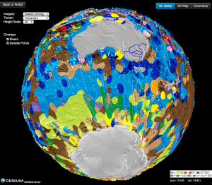
PLOS ONE – The GPlates Portal: Cloud-Based Interactive 3D Visualization of Global Geophysical and Geological Data in a Web Browser
Author List: Dietmar Müller, Xiaodong Qin, David Sandwell, Adriana Dutkiewicz, Simon Williams, Nicolas Flament, Stefan Maus, Maria Seton Citation: Müller, R. D., Qin, X., Sandwell, D. T., Dutkiewicz, A., Williams, S. E., Flament, N., Maus, S., & Seton, M. (2016). The GPlates Portal: Cloud-Based Interactive 3D Visualization of Global Geophysical and Geological Data in a Web Browser. … Read more…
Earth and Planetary Science Letters – Formation of Australian continental margin highlands driven by plate–mantle interaction
Author List: Dietmar Müller, Nicolas Flament, Kara Matthews, Simon Williams and Mike Gurnis Citation: Müller, R. D., Flament, N., Matthews, K. J., Williams, S. E., & Gurnis, M. (2016). Formation of Australian continental margin highlands driven by plate–mantle interaction. Earth and Planetary Science Letters, 441, 60–70. http://dx.doi.org/10.1016/j.epsl.2016.02.025 Formation of Australian continental margin highlands driven by plate–mantle … Read more…
Geophysical Research Letters – Alignment between seafloor spreading directions and absolute plate motions through time
Author List: Simon Williams, Nicolas Flament and Dietmar Müller Citation: Williams, S., Flament, N., & Müller, R. D. (2016). Alignment between seafloor spreading directions and absolute plate motions through time. Geophysical Research Letters, 43, 1472–1480, doi:10.1002/2015GL067155. Alignment between seafloor spreading directions and absolute plate motions through time
Earth-Science Reviews – The Late Cretaceous to recent tectonic history of the Pacific Ocean basin
Wright, N. M., Seton, M., Williams, S. E., & Müller, R. D. (2016). The Late Cretaceous to recent tectonic history of the Pacific Ocean basin. Earth-Science Reviews, 154, 138–173. http://dx.doi.org/10.1016/j.earscirev.2015.11.015 The Late Cretaceous to recent tectonic history of the Pacific Ocean basin
Earth and Planetary Science Letters – Assessing the role of slab rheology in coupled plate-mantle convection models
Bello, L., Coltice, N., Tackley, P. J., Müller, R. D., & Cannon, J. (2015). Assessing the role of slab rheology in coupled plate-mantle convection models. Earth and Planetary Science Letters, 430, 191–201. http://dx.doi.org/10.1016/j.epsl.2015.08.010 Assessing the role of slab rheology in coupled plate-mantle convection models
Tectonophysics – Full-fit reconstruction of the South China Sea conjugate margins
Bai, Y., Wu, S., Liu, Z., Müller, R. D., Williams, S. E., Zahirovic, S., & Dong, D. (2015). Full-fit reconstruction of the South China Sea conjugate margins. Tectonophysics, 661, 121–135. http://dx.doi.org/10.1016/j.tecto.2015.08.028 Full-fit reconstruction of the South China Sea conjugate margins
Geophysical Research Letters – Mantle-induced subsidence and compression in SE Asia since the early Miocene
Author List: Ting Yang, Mike Gurnis, Sabin Zahirovic Citation: Yang, T., M. Gurnis, and S. Zahirovic (2016), Mantle–induced subsidence and compression in SE Asia since the early Miocene, Geophysical Research Letters, doi: 10.1002/2016GL068050. Mantle-induced subsidence and compression in SE Asia since the early Miocene
GPlates Portal International Media Coverage
 The recent article on the GPlates Portal published in PLOS ONE by Prof Dietmar Müller, Xiaodong Qin, Prof David Sandwell, Dr Adriana Dutkiewicz, Dr Simon Williams, Dr Nicolas Flament, Dr Stefan Maus, and Dr Maria Seton, has received significant international media attention over the past week, featuring in articles from Australia, UK, US, India, and UAE!
See the list of online media below, and check out the interactive globes yourself!
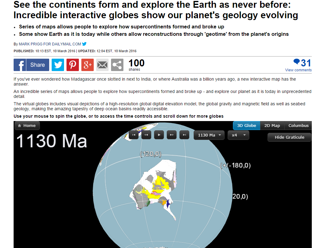
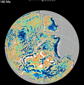
Virtual Time Machine Of Earth’s Geology Now In The Cloud
How did Madagascar once slot next to India? Where was Australia a billion years ago?
Cloud-based virtual globes developed by a team led by University of Sydney geologists mean anyone with a smartphone, laptop or computer can now visualise, with unprecedented speed and ease of use, how the Earth evolved geologically.
Reported today in PLOS ONE, the globes have been gradually made available since September 2014. Some show Earth as it is today while others allow reconstructions through ‘geological time’, harking back to the planet’s origins.
Uniquely, the portal allows an interactive exploration of supercontinents. It shows the breakup and dispersal of Pangea over the last 200 million years. It also offers a visualisation of the supercontinent Rodinia, which existed 1.1 billion years ago. Rodinia gradually fragmented, with some continents colliding again more than 500 million years later to form Gondwanaland.
EarthByte Welcomes Ian Howson
EarthByte welcomes Ian Howson to the group. He will be working with us as a software developer on the Badlands Project
Northwest Shelf in the media
An upcoming IODP expedition along the WA coast led by Prof Stephen has received significant media attention. The two month expedition will be drilling into the seabed in order to examine the climatic conditions of the North West continental shelf over the past five million years.
NICTA and University of Sydney creates world first digital map of seafloor geology
 New digital seafloor geology map uses artificial intelligence and big data to boost understanding of the ocean floor
A collaboration between National ICT Australia (NICTA) and the University of Sydney School of Geosciences has created the first digital map of seafloor sediments.
Big Data Maps World’s Ocean Floor
Scientists from the University of Sydney’s School of Geosciences have led the creation of the world’s first digital map of the seafloor’s geology.
It is the first time the composition of the seafloor, covering 70 percent of the Earth’s surface, has been mapped in 40 years; the most recent map was hand drawn in the 1970s.
Published in the latest edition of Geology, the map will help scientists better understand how our oceans have responded, and will respond, to environmental change. It also reveals the deep ocean basins to be much more complex than previously thought.
The IntraCONtinental basinS (ICONS) atlas
The ICONS atlas is a collection of basin data for over 240 intracontinental sedimentary basins, displaying crustal structure data, computed extension factors and tectonic subsidence grids and derivatives thereof as well as the dynamic topography evolution of a given basin. The atlas was compiled by Christian Heine as part of his PhD project investigating the formation and … Read more…
Herold et al. 2008 Mid Miocene topographic/bathymetric dataset
Citation: Herold, N., Seton, M., Muller, R.D., You, Y. and Huber, M. (2008). Middle Miocene tectonic boundary conditions for use in climate models. Geochemisty Geophysics Geosystems, 9, Q10009. doi:10.1029/2008GC002046. Abstract: Utilizing general circulation models (GCMs) for paleoclimate study requires the construction of appropriate model boundary conditions. We present a middle Miocene paleotopographic and paleobathymetric reconstruction … Read more…
Middle Miocene tectonic boundary conditions for use in climate models
Herold, N., Seton, M., Muller, R.D., You, Y. and Huber, M. (2008). Middle Miocene tectonic boundary conditions for use in climate models. Geochemisty Geophysics Geosystems, 9, Q10009. doi:10.1029/2008GC002046. Middle Miocene tectonic boundary conditions for use in climate models