Prospectivity of Western Australian iron ore from geophysical data using a reject option classifier

Prospectivity of Western Australian iron ore from geophysical data using a reject option classifier - figure

Prospectivity of Western Australian iron ore from geophysical data using a reject option classifier - figureCitation
Merdith, A. S., Landgrebe, T. C., & Müller, R. D. (2015). Prospectivity of Western Australian iron ore from geophysical data using a reject option classifier. Ore Geology Reviews. http://dx.doi.org/10.1016/j.oregeorev.2015.03.014

Abstract
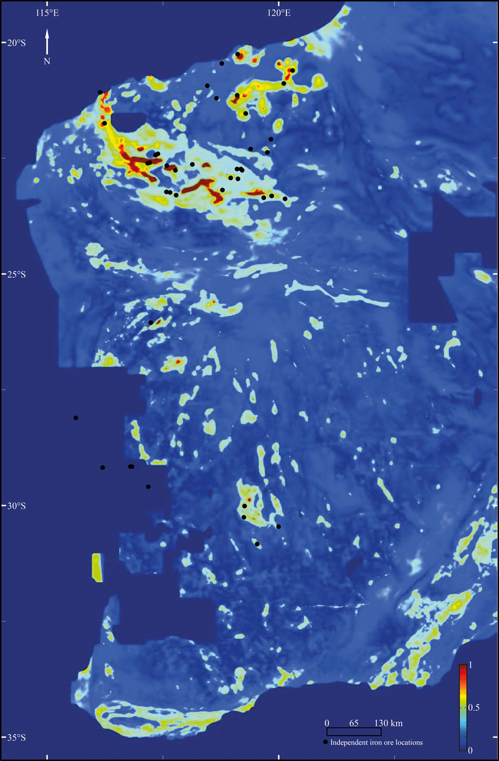
There has recently been a rapid growth in the amount and quality of digital geological and geophysical data for the majority of the Australian continent. Coupled with an increase in computational power and the rising impor- tance of computational methods, there are new possibilities for a large scale, low expenditure digital exploration of mineral deposits. Here we use a multivariate analysis of geophysical datasets to develop a methodology that utilises machine learning algorithms to build and train two-class classifiers for provincial-scale, greenfield min- eral exploration. … Read more…

Share

Seafloor lithology of the ocean basins

Lithology globe Aus Ant view

Lithology globe Aus Ant viewCitation
Dutkiewicz, A., Müller, R. D., O’Callaghan, S., & Jónasson, H. (2015). Census of seafloor sediments in the world’s ocean. Geology, G36883-1. doi: 10.1130/G36883.1.

Abstract
Knowing the patterns of distribution of sediments in the global ocean is critical for understanding biogeochemical cycles and how deep-sea deposits respond to environmental change at the sea surface. We present the first digital map of seafloor lithologies based on descriptions of nearly 14,500 samples from original cruise reports, interpolated using a support vector machine algorithm. We show that sediment distribution is more complex, with significant deviations from earlier hand-drawn maps, and that major lithologies occur in drastically different proportions globally. … Read more…

Share

Resolution and Revelation – Strategies for imaging and exploring the Earth’s crust and near-surface

Speaker
Assoc Prof Anya Reading, UTAS.

Date & Time
Tuesday 20 October, 11 AM

Location
Madsen Building, Level 4 – Conference Room

Abstract
Highlights of research in computational geophysics from the UTAS group in recent years are presented. In the quest for improved resolution of contrasts in structure in the Earth’s crust, the use of ambient seismic energy is outlined together with results from recent field experiments in southeast Australia. Moving up the frequency range, a novel ambient energy technique for characterising upper layers of cover for minerals targeting will also
be covered.  … Read more…

Share

Granular physics in geosciences

Speaker Prof Itai Einav, School of Civil Engineering. Date & Time Wednesday 14 October, 11 AM Location Madsen Building, Level 3 – Room 336 Summary During this seminar Prof Itai Einav will provide an overview for some of the research activities carried out in the Particles and Grains Laboratory (PGL) at the School of Civil … Read more…

Simon Williams reports from the TECTA Cruise

Water Column mapping of the Tasman Sea from the TECTA voyage

Water Column mapping of the Tasman Sea from the TECTA voyageEarthByter Simon Williams is currently part of an international team of scientists sailing around the Tasman Sea on board the French Research Vessel ‘L’Atalante’. The voyage is collecting geophysical data that will help to unravel the mysteries of Earth’s geodynamic evolution and subduction initiation East of Australia, as well as profound changes in Southwest Pacific climate and ocean currents through geological history. To read the news from the voyage, download the PDF newsletters below.

Newsletter Number 1, 10 September 2015 – pdf
Newsletter Number 2, 17 September 2015 – pdf
Newsletter Number 3, 25 September 2015 – pdf
Newsletter Number 4, 1 October 2015 – pdf
Read more…

Share

Homeward Bound… Big Data Reveals Geology of World’s Ocean Floor

Lithology globe Aus Ant view

The 2015 Ocean Innovation (OI) conference takes place in St. John’s, Newfoundland and Labrador, Canada during October and focuses on “mapping our oceans.” For each OI conference, a special issue of The Journal of Ocean Technology (JOT) that complements the conference’s theme is released. A series of essays, peer review technical papers, and columns are included and … Read more…

Influence of subduction history on South American topography

Case 4 paleotopography 16MaCitation
Flament, N., Gurnis, M., Müller, R. D., Bower, D. J., & Husson, L. (2015). Influence of subduction history on South American topography. Earth and Planetary Science Letters, 430, 9-18. doi: 10.1016/j.epsl.2015.08.006.

Abstract
The Cenozoic evolution of South American topography is marked by episodes of large-scale uplift and subsidence not readily explained by lithospheric deformation. The drying up of the inland Pebas system, the drainage reversal of the Amazon river, the uplift of the Sierras Pampeanas and the uplift of Patagonia have all been linked to the evolution of mantle flow since the Miocene in separate studies. Here we investigate the evolution of long-wavelength South American topography as a function of subduction history in a time-dependent global geodynamic model. This model is shown to be consistent with these inferred changes, as well as with the migration of the Chaco foreland basin depocentre, that we partly attribute to the inboard migration of subduction resulting from Andean mountain building. … Read more…

Share

Earth and Planetary Science Letters – Influence of subduction history on South American topography

Case 4 paleotopography 16Ma

Flament, N., Gurnis, M., Müller, R. D., Bower, D. J., & Husson, L. (2015). Influence of subduction history on South American topography. Earth and Planetary Science Letters, 430, 9-18. doi: 10.1016/j.epsl.2015.08.006. Influence of subduction history on South American topography

Basin Hub members meeting – AAPG ICE 2015

BGH group photo at the AAPG ICE 2015 (2)

BGH group photo at the AAPG ICE 2015 (2)Basin Hub members met in Melbourne during the AAPG ICE meeting for a short meeting, which included an overview of the hub for members new to it, an update of the hub’s organisational structure and a review of recent achievements and the research program for the next 12 months.
Read more…

Share

Some Surprising Ways That Plate Tectonic, Paleogeographic, and Paleoclimatic Models are Used in Resource (Hydrocarbon & Mineral) Exploration

Speaker
Malcolm Ross, GameChanger, Shell, Houston, TX, United States.

Date & Time
Friday 18 September, 11 AM

Location
Madsen Building, Level 4 – Conference Room

Abstract
Since the advent of plate tectonic theory in the 1960s, those charged with the exploration for hydrocarbon and mineral resources have looked to apply the theoretical advancements in that domain to the practical challenges of their pursuit of resources to exploit. … Read more…

Share

Nicky Wright attends University of Michigan’s ‘Mountain Ranges and High Plateaus’ course

Nicky Wright Mountain Ranges and High Plateaus group photo

Nicky Wright recently attended the 2-week graduate summer course ‘Mountain Ranges and High Plateaus‘, held at the University of Michigan’s field station in Wyoming. This was only the second time the University of Michigan has held this course, which featured instructors from five other U.S. universities and international and U.S. graduate students from both the … Read more…

EarthByters attend University of Sydney Open Day

Sydney Uni Open Day

We are very proud of our team of volunteers who represented EarthByte at the University of Sydney Open Day on Saturday. EarthByte had six volunteers who set up at 8am, and presented activities at the Eastern Avenue hands-on interactive stations until 4pm. This is a great outreach activity, and very reassuring to see the new generations get … Read more…

EarthByte attends JAMSTEC workshop in Tokyo

Lord Howe Rise workshop JAMSTEC August 2015

Lord Howe Rise workshop JAMSTEC August 2015A group of international scientists, including EarthByter Dietmar Müller, is gathering this week at the Japan Agency for Marine-Earth Science and Technology (JAMSTEC) in Tokyo to put the finishing touches on an IODP proposal to drill through the Cretaceous stratigraphic section of the Lord Howe Rise (LHR), a submerged continental fragment that was once part of eastern Gondwanaland. The principal Australian agency in this collaborative project with JAMSTEC is Geoscience Australia, with Andrew Heap playing a leading role. The main emergent part of the LHR today is Lord Howe Island, an eroded remnant of a 7 million year old shield volcano, known to many Australians as a fine, but slightly pricey, getaway from the hustle and bustle of city life, full of kingfish, great beaches, a pristine coral reef and excellent outcrops of volcanic rocks and calcarenites. But what does not meet the eye is what lies underneath: several kilometers of Cenozoic and Cretaceous sediments that provide a rich record of subduction along eastern Gondwanaland, … Read more…

Share

EarthByte welcomes four new Research Assistants

New Research Assistants - 19 August 2015

This week EarthByte welcomes new Research Assistants Jodie Pall, Lauren Harrington, Joanna Tobin and Lena O’Toole to the group. Lena, Lauren and Joanna are hired through the Basin GENESIS Hub project and Jodie is hired through a Discovery project fund. Congratulations and welcome! Our long-time Research Assistants Serena Yeung and James Egan will also be working with the … Read more…

Opening of ARC Basin Genesis INDUSTRIAL TRANSFORMATION RESEARCH HUB

Basin GENESIS Hub opening group photo 19 August 2015

Basin GENESIS Hub opening group photo 19 August 2015The ARC Research Hub for Basin Geodynamics and Evolution of Sedimentary Systems (Basin GENESIS Hub) opened today at a reception held in the Charles Perkins Centre at the University of Sydney. The launch as attended by representatives from Universities, industry, Geoscience Australia, the ARC, the NCI and the Office of the NSW Chief Scientist and Engineer.

The Basin GENESIS Hub will use computer modelling to fine-tune our understanding of the nation’s sedimentary basins, which hold many of the natural resources we use in day-to-day life.

The research will be of fundamental importance to the geo-software industry used by exploration and mining companies, explains Hub Director Professor Dietmar Müller from the University of Sydney.  … Read more…

Share

Opening speech, ARC Research Hub for Basin GEodyNamics and Evolution of SedImentary Systems

Dietmar Müller's BGH opening speech 19 August 2015

Dietmar Müller's BGH opening speech 19 August 2015Prof Dietmar Müller, Wed 19 August 2015

Good afternoon! On behalf of the University of Sydney and the School of Geosciences I welcome you to the opening of the ARC Research Hub for Basin GEodyNamics and Evolution of SedImentary Systems (in short Basin Genesis Hub).

Before we begin the proceedings, I would like to acknowledge and pay respect to the traditional owners of the land on which we meet – the Gadigal people of the Eora Nation. It is upon their ancestral lands that the University of Sydney is built.

I would like to extend a special thank you to our industry partners, Statoil, Chevron, Oil Search, Intrepid Geophysics and 3D-GEO, many of whom are here today. We are especially pleased to have with us today Ms Leanne Harvey, Executive General Manager of the ARC.  … Read more…

Share

Ocean sediment map makes world news

Lithology globe Aus Ant view

Lithology globe Aus Ant view
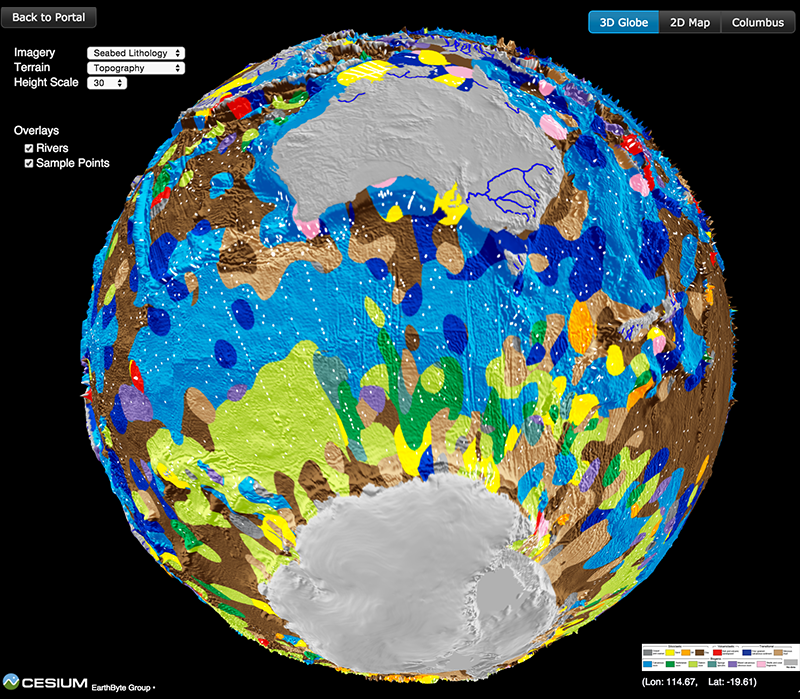
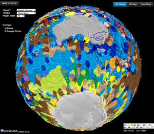
The recently-published ocean sediment map made by Dr Adriana Dutkiewicz and colleagues has taken the world’s media by storm. It’s been reported online and in press, from Australia to Cuba, Hungary and many other countries! See the updated list of media items below, and check out the link to the interactive 3D globe with the ocean sediments map.

Countries where the story has been covered so far:

Australia, UK, USA, India, Italy, Germany, Spain, Hungary, Austria, Cuba, Costa Rica and Peru.

Radio Interviews
ABC 774 Melbourne
World’s first digital seafloor map reveals ‘paradise’ – ABC Rural Radio
ABC 702 Sydney
BBC Radio 5 Live’s “Up All Night”
It took more than a year of research and sifting through thousands of samples to generate the world’s first digital map of the seafloor – ABC Country Radio (Interview at 41:10)  … Read more…

Share

EarthByte has a new website!

Australia vgg NW view

Today we officially launch the new EarthByte website! The new site has dedicated ‘Global Plate Models’ and ‘GPlates’ pages (Resources) for quick and easy access to our published GPlates-compatible kinematic models, search bar functionality, a responsive layout that is compatible with handheld devices, detailed people pages, an ‘Outreach’ space, and news, awards, media and research … Read more…

Basin and Landscape Dynamics (Badlands)

Badlands image

Basin and Landscape Dynamics (Badlands) is a parallel TIN-based landscape evolution model, built to simulate topography development at various space and time scales. The model is capable of simulating hillslope processes, fluvial incision (erosion/transport/deposition), spatially and temporally varying geodynamic (3D displacements) and climatic forces which can be used to simulate changes in base level, as … Read more…

High horizontal fault displacement rates and landscape evolution

High horizontal fault displacement rates and landscape evolution video featured image

In this numerical model of landscape evolution we impose over 2 million of years deformation produced with the Underworld software over an initial flat surface, ie a 256 km square box at a resolution of 1 km. On top of the deformed surface, a landscape evolution model, Badlands, is used to simulate both hillslope and … Read more…

Virtual seafloor geology globe spinning North-South

Lithology globe Aus Ant view

This spinning virtual seafloor geology globe is composed of a set of screen captures of an interactive digital globe portraying the distribution of different seafloor sediments available at the Gplates Portal.Citation Dutkiewicz, A., Müller, R. D., O’Callaghan, S., & Jónasson, H. (2015). Census of seafloor sediments in the world’s ocean. Geology, G36883-1. doi: 10.1130/G36883.1.Download paper … Read more…

Virtual seafloor geology globe spinning East-West

Lithology globe Aus Ant view

This spinning virtual seafloor geology globe is composed of a set of screen captures of an interactive digital globe portraying the distribution of different seafloor sediments available at the Gplates Portal.Citation Dutkiewicz, A., Müller, R. D., O’Callaghan, S., & Jónasson, H. (2015). Census of seafloor sediments in the world’s ocean. Geology, G36883-1. doi: 10.1130/G36883.1.Download paper … Read more…

Big data reveals geology of world’s ocean floor

Lithology globe Aus Ant view

Lithology globe Aus Ant viewA team led by the University of Sydney School of Geosciences has created the first digital globe of seafloor sediments.

Ocean sediments cover 70% of our planet’s surface, forming the substrate for the largest ecosystem on Earth and its largest carbon reservoir – but the most recent map of seafloor geology was drawn by hand over 40 years ago, at the dawn of modern ocean exploration.

That’s about to change. In a gargantuan effort Adriana Dutkiewicz and her colleagues carefully analysed and categorised 15,000 seafloor sediment samples to reveal the nature of sedimentary blankets over ocean ridges, seamounts and the vast abyssal plains. She teamed up with big data experts to find the best way to use modern computer algorithms to turn the vast sea of point observations into a continuous digital map.  … Read more…

Share

Big Data Knowledge Discovery

Big Data Knowledge Discovery is an interdisciplinary research initiative that focuses on the scientific challenges and opportunities presented by the use of the new techniques of data science applied in the natural sciences. This research initiative brings together world class discipline leaders in the data-intensive sciences of Geo Sciences, Life Sciences and Physical Sciences with … Read more…

EarthByte participates in Gondwana Map Project workshop in Rio de Janeiro

Nicholas Barnett-Moore with the Gondwana Map Project team in Rio de Janeiro

Nicholas Barnett-Moore speaking at the Gondwana Map Project workshop in Rio de JaneiroRecently the EarthByte group was invited to participate in the two-week long ‘Rio Gondwana Workshop’, in Rio de Janeiro (22nd June – 3rd July), that focused on the development of a new Gondwana geology map. This is part of the IGCP Project 628 – The Gondwana Map Project. The collaborators involved in this project were very interested in incorporating GPlates into their workflow for developing the Gondwana geological map.

PhD candidate Nicholas Barnett-Moore represented the EarthByte Group. He participated in a week-long discussion on the efforts and new thinking required to develop a new geological map(s) of Gondwana. … Read more…

Share