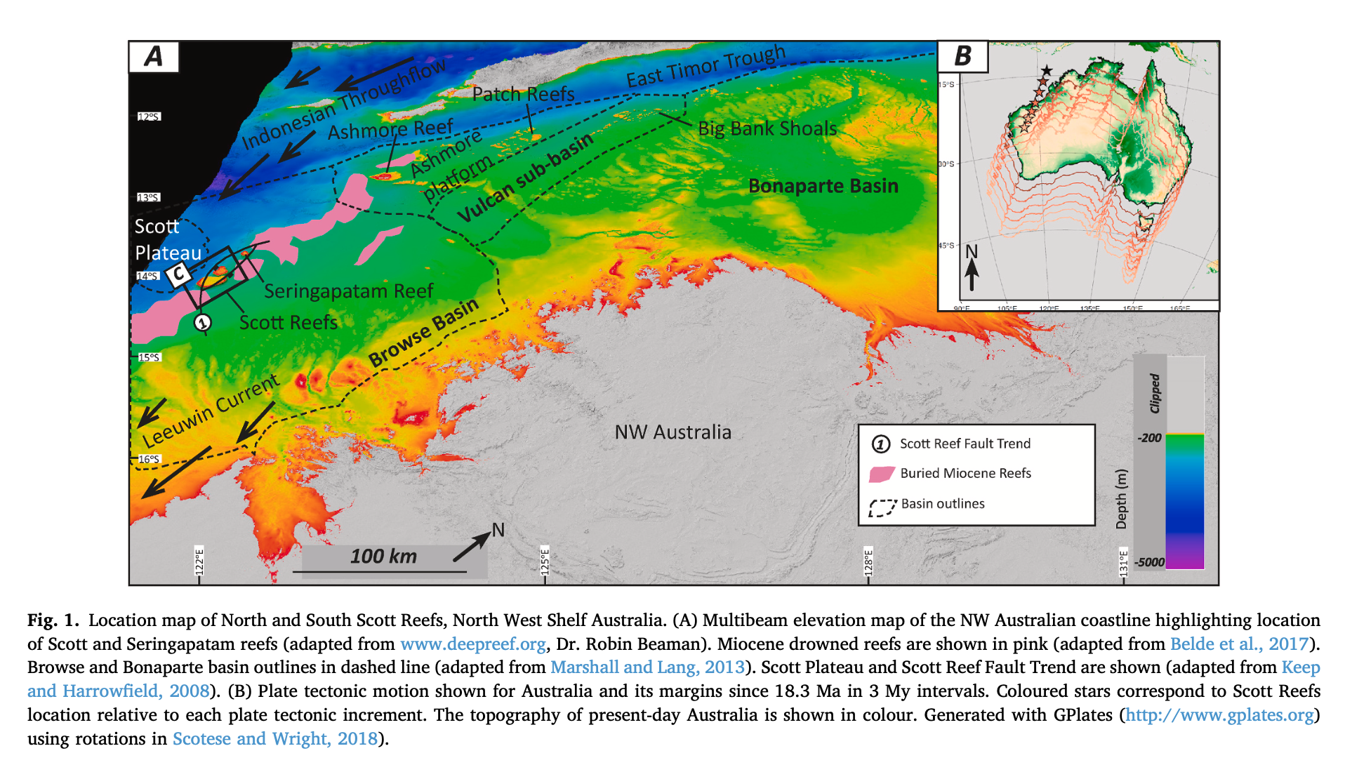
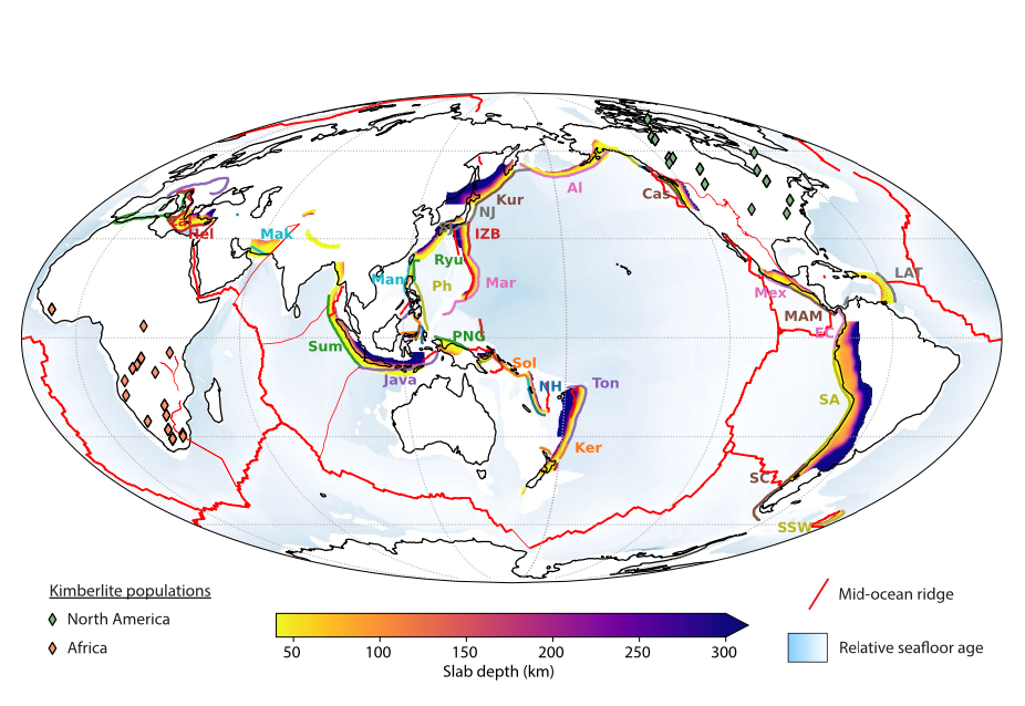
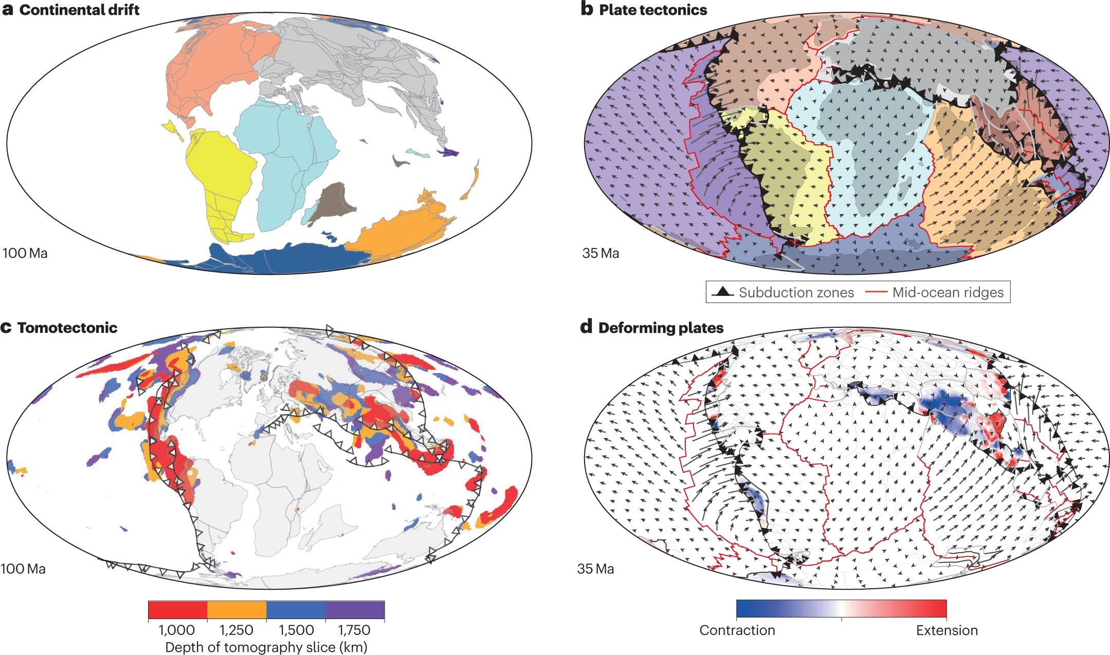
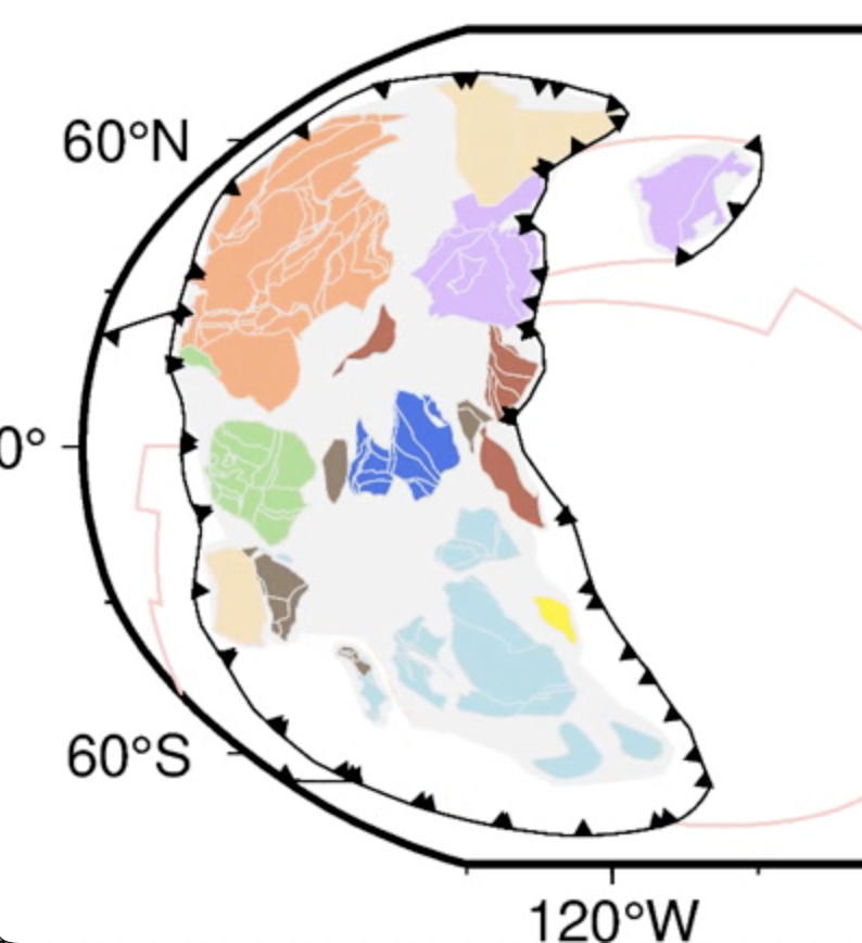
G-cubed: Slow Geodynamics and Fast Morphotectonics in the Far East Tethys

How can the sluggish, long-wavelength mantle convection be expressed by so many time and space scales of morphotectonic activity? To investigate these relationships, we explore the Java-Banda subduction zone, where geodynamic records cluster. In the far-East Tethys, the exceptionally arcuate Banda subduction zone circumscribes the deepest oceanic basin on Earth, seismotectonic activity slices the upper … Read more…

Front Earth Sci: Two-step Gravity Inversion Reveals Variable Architecture of African Cratons

The lithospheric build-up of the African continent is still to a large extent unexplored. In this contribution, we present a new Moho depth model to discuss the architecture of the three main African cratonic units, which are: West African Craton, Congo Craton, and Kalahari Craton. Our model is based on a two-step gravity inversion approach … Read more…

Extending full-plate tectonic models into deep time: Linking the Neoproterozoic and the Phanerozoic

Recent progress in plate tectonic reconstructions has seen models move beyond the classical idea of continental drift by attempting to reconstruct the full evolving configuration of tectonic plates and plate boundaries. A particular problem for the Neoproterozoic and Cambrian is that many existing interpretations of geological and palaeomagnetic data have remained disconnected from younger, better-constrained … Read more…

Evolution of Earth’s tectonic carbon conveyor belt

This video shows plate motions, carbon storage within tectonic plates and carbon degassing along mid-ocean ridges and subduction zones through time. Our carbon model shows these processes alone cannot explain global cooling in the Cenozoic Era. The effects of rock erosion, not shown here, played a key role. Arrows indicate plate motion speed relative to … Read more…

Terra Nova: Timing of partial melting and granulite formation during the genesis of high to ultra-high temperature terranes: Insight from numerical experiments

Long-lived high to ultra-high temperature (HT-UHT) granulitic terranes formed throughout Earth’s history. Yet, the detailed processes involved in their formation re- main unresolved and notably the sequence of appearance and duration of migmatisa- tion and granulites conditions in the orogenic cycle. These processes can be evaluated by analytical and numerical models. First, solving the steady-state … Read more…

Earth Science Reviews: Sea-level fluctuations driven by changes in global ocean basin volume following supercontinent break-up

Long-term variations in eustatic sea level in an ice-free world, which existed through most of the Mesozoic and early Cenozoic eras, are partly driven by changes in the volume of ocean basins. Previous studies have determined ocean basin volume changes from plate tectonic reconstructions since the Mesozoic; however, these studies have not considered a number … Read more…

Identifying Characteristic and Anomalous Mantle From the Complex Relationship Between Abyssal Hill Roughness and Spreading Rates

The dependence of abyssal hill roughness on mid-ocean ridge (MOR) spreading rate is an important indicator for faulting and volcanism. I reanalyze this relationship using a global gravity-based prediction of root-mean-square (RMS) heights, enabling dense sampling of RMS/spreading rate space and thus a far more detailed examination than possible with bathymetric data. RMS histograms are … Read more…

Nature Commmunications: Impact of green clay authigenesis on element sequestration in marine settings

Retrograde clay mineral reactions (reverse weathering), including glauconite formation, are first-order controls on element sequestration in marine sediments. Here, we report substantial element sequestration by glauconite formation in shallow marine settings from the Triassic to the Holocene, averaging 3 ± 2 mmol·cm−²·kyr−1 for K, Mg and Al, 16 ± 9 mmol·cm−²·kyr−1 for Si and 6 ± 3 mmol·cm−²·kyr−1 for Fe, which is ~2 orders of magnitude higher … Read more…

Geology: Deep-sea hiatuses track the vigor of Cenozoic ocean bottom currents

The deep-sea stratigraphic record is full of gaps. These hiatuses track changes in ocean circulation and chemistry, but determining their timing and causes has been limited by sparse data and incomplete knowledge of ocean gateway evolution in earlier studies. We combine a significantly expanded, age-calibrated deep-sea stratigraphic database with a global tectonic and paleo–water depth … Read more…

Scientific Reports: Constraining the response of continental‐scale groundwater flow to climate change

Numerical models of groundwater flow play a critical role for water management scenarios under climate extremes. Large‐scale models play a key role in determining long-range flow pathways from continental interiors to the oceans, yet struggle to simulate the local flow patterns offered by small‐scale models. We have developed a highly scalable numerical framework to model … Read more…

EPSL: Long-term Phanerozoic sea level change from solid Earth processes

The sedimentary rock record suggests that global sea levels may have fluctuated by hundreds of meters throughout Phanerozoic times. Long-term (10–80 Myr) sea level change can be inferred from paleogeographic reconstructions and stratigraphic methods can be used to estimate sea level change over 1–10 Myr in tectonically quiescent regions assumed to be stable. Plate tectonic … Read more…

Remote Sensing: A Comparative Study of Convolutional Neural Networks and Conventional Machine Learning Models for Lithological Mapping Using Remote Sensing Data

Lithological mapping is a critical aspect of geological mapping that can be useful in studying the mineralization potential of a region and has implications for mineral prospectivity mapping. This is a challenging task if performed manually, particularly in highly remote areas that require a large number of participants and resources. The combination of machine learning … Read more…

Journal of Asian Earth Sciences: The roles and seismic expressions of turbidites and mass transport deposits using stratigraphic forward modeling and seismic forward modeling

Turbidity currents and mass transport are two principal processes in deepwater settings. However, their roles in shaping deepwater depositional systems and interpreting their deposits in seismic profiles have not been fully settled due to the lack of extensive well data and high-quality seismic data in comparison with onshore oil fields. Therefore, this study integrated stratigraphic … Read more…

The efficiency of fractal techniques in geochemical anomaly delineation within BLEG and <180 μm stream sediments in Western Turkey

A new article published recently by Huseyin Yilmaz (Dokuz Eylul University, Turkey), Behnam Sadeghi (EarthByte Group, USYD), and David Cohen (UNSW) in Journal of Geochemical Exploration (JGE): Abstract: In regional exploration for Au mineralization using stream sediment geochemistry, multielement analysis following cyanide leaching of bulk samples or aqua regia digestion of the <180 μm fraction are the two most common … Read more…

Geomorphology: Combining stratigraphic forward modeling and susceptibility mapping to investigate the origin and evolution of submarine canyons

The debate on the submarine canyon origin between the upslope erosion model dominated by retrogressive mass failures and the downslope erosion model controlled by gravity flows has not been fully settled. However, this debate is critical for explaining submarine canyon evolution. This study combines susceptibility mapping and stratigraphic forward modeling (SFM) to examine the origin … Read more…

Elements: Carbonatites and global tectonics

Carbonatites have formed for at least the past three billion years. But over the past 700 My the incidence of carbonatites have significantly increased. We compile an updated list of 609 carbonatite occurrences and plot 387 of known age on plate tectonic reconstructions. Plate reconstructions from Devonian to present show that 75% of carbonatites are … Read more…

Terra Nova: The Louisiade ophiolite: A missing link in the western Pacific

Recent dredging of a 100 km long ridge along the northernmost part of the Louisiade Plateau (LP) recovered serpentinized peridotites, MORB (mid-ocean-ridge basalt) and volcaniclastic breccia–conglomerates. Clinopyroxene, Cr-spinel and bulk rocks show that the serpentinites are harzburgites to dunites, whereas hornblende phenocrysts from volcaniclastic rocks reflect hydrous, andesitic volcanism. The association of MORB, depleted mantle rocks … Read more…

Geochemical anomaly definition using stream sediments landscape modeling

A new research paper published in Ore Geology Reviews based on a collaboration between Dr. Behnam Sadeghi from EarthByte Group, USYD, and several research institutes in China, including: China University of Geosciences: State Key Laboratory of Geological Processes and Mineral Resources Hebei GEO University: 1) Institute of Resource and Environmental Engineering, 2) Hebei Key Laboratory … Read more…

Nature Geoscience: Dynamics of the abrupt change in Pacific Plate motion around 50 million years ago

A drastic change in plate tectonics and mantle convection occurred around 50 Ma as exemplified by the prominent Hawaiian– Emperor Bend. Both an abrupt Pacific Plate motion change and a change in mantle plume dynamics have been proposed to account for the Hawaiian–Emperor Bend, but debates surround the relative contribution of the two mechanisms. Here … Read more…

Scientific Reports: The evolution of basal mantle structure in response to supercontinent aggregation and dispersal

Seismic studies have revealed two Large Low-Shear Velocity Provinces (LLSVPs) in the lowermost mantle. Whether these structures remain stable over time or evolve through supercontinent cycles is debated. Here we analyze a recently published mantle flow model constrained by a synthetic plate motion model extending back to one billion years ago, to investigate how the … Read more…

Special Issue: Mineral exploration: a journey from fieldwork, to laboratory work, computational modelling and mineral processing

Dr. Behnam Sadeghi from EarthByte Group, and Profs. Astrid Holzheid (Christian-Albrechts-Universität Kiel, Germany) and Hongbo Zhao (Central South University, China) organised a new Special Issue for the journal “Geochemistry” (former “Chemie der Erde”) in 2021, which has been published recently. This SI has covered some topics in mineral exploration, including fieldwork, laboratory work, computational modelling, … Read more…

PNAS: High 3He/4He in central Panama reveals a distal connection to the Galapagos plume

Significance We report the discovery of anomalously high 3He/4He in “cold” geothermal fluids of central Panama, far from any active volcanoes. Combined with independent constraints from lava geochemistry, mantle source geochemical anomalies in Central America require a Galapagos plume contribution that is not derived from hotspot track recycling. Instead, these signals likely originate from large-scale … Read more…

Communications Earth & Environment: Quaternary landscape dynamics boosted species dispersal across Southeast Asia

Sundaland, the inundated shelf separating Java, Sumatra and Borneo from the Malay Peninsula, is of exceptional interest to biogeographers for its species richness and its position at the junction between the Australasian and Indomalay biogeographic provinces. Owing to its low elevation and relief, its physiography is contingent on relative sea-level change, which drove Quaternary species … Read more…

Detection of mineralization stages using zonality and multifractal modeling based on geological and geochemical data in the Au-(Cu) intrusion-related Gouzal-Bolagh deposit, NW Iran

As the co- and corresponding author, Dr. Behnam Sadeghi, from EarthByte Group, has recently published this paper in “Ore Geology Reviews”. This research is based on a collaborative project with the Geological Survey of Iran. Abstract: The objective of this paper is to detect various gold and copper mineralization stages according to surface lithogeochemical data … Read more…

Remote Sensing of the Enivronment: A review of machine learning in processing remote sensing data for mineral exploration

The decline of the number of newly discovered mineral deposits and increase in demand for different minerals in recent years has led exploration geologists to look for more efficient and innovative methods for processing different data types at each stage of mineral exploration. As a primary step, various features, such as lithological units, alteration types, … Read more…

Earth Surface Dynamics: Tectonically and climatically driven mountain-hopping erosion in central Guatemala from detrital 10Be and river profile analysis

The rise of a mountain range affects moisture circulation in the atmosphere and water runoff across the land surface, modifying the distribution of precipitation and drainage patterns in its vicinity. Water routing in turn affects erosion on hillslopes and incision in river channels on surrounding mountain ranges. In central Guatemala, two parallel, closely spaced mountain … Read more…

Geosphere: Fast Pliocene integration of the Central Anatolian Plateau drainage: Evidence, processes, and driving forces

Continental sedimentation was widespread across the Central Anatolian Plateau in Miocene– Pliocene time, during the early stages of plateau uplift. Today, however, most sediment produced on the plateau is dispersed by a well-integrated drainage and released into surrounding marine depocenters. Residual long-term (106–107 yr) sediment storage on the plateau is now restricted to a few … Read more…

Marine and Petroleum Geology: Single-phase vs two-phase rifting: Numerical perspectives on the accommodation of extension during continental break-up

How continental lithosphere responds to extension is a function of the dynamic interaction between layers of differing rheological properties, including the shallow crust, deep crust, lithospheric mantle, and asthenosphere. We investigate the first-order controls on the modes of extension and timing of transition from continental rifting to development of continental margins via a suite of … Read more…

Basin Research: Modelling the role of dynamic topography and eustasy in the evolution of the Great Artesian Basin

Widespread flooding of the Australian continent during the Early Cretaceous, referred to as the Eromanga Sea, deposited extensive shallow marine sediments throughout the Great Artesian Basin (GAB). This event had been considered ‘out of sync’ with eustatic sea level and was instead solely attributed to dynamic subsidence associated with Australia’s passage over eastern Gondwanan subducted … Read more…