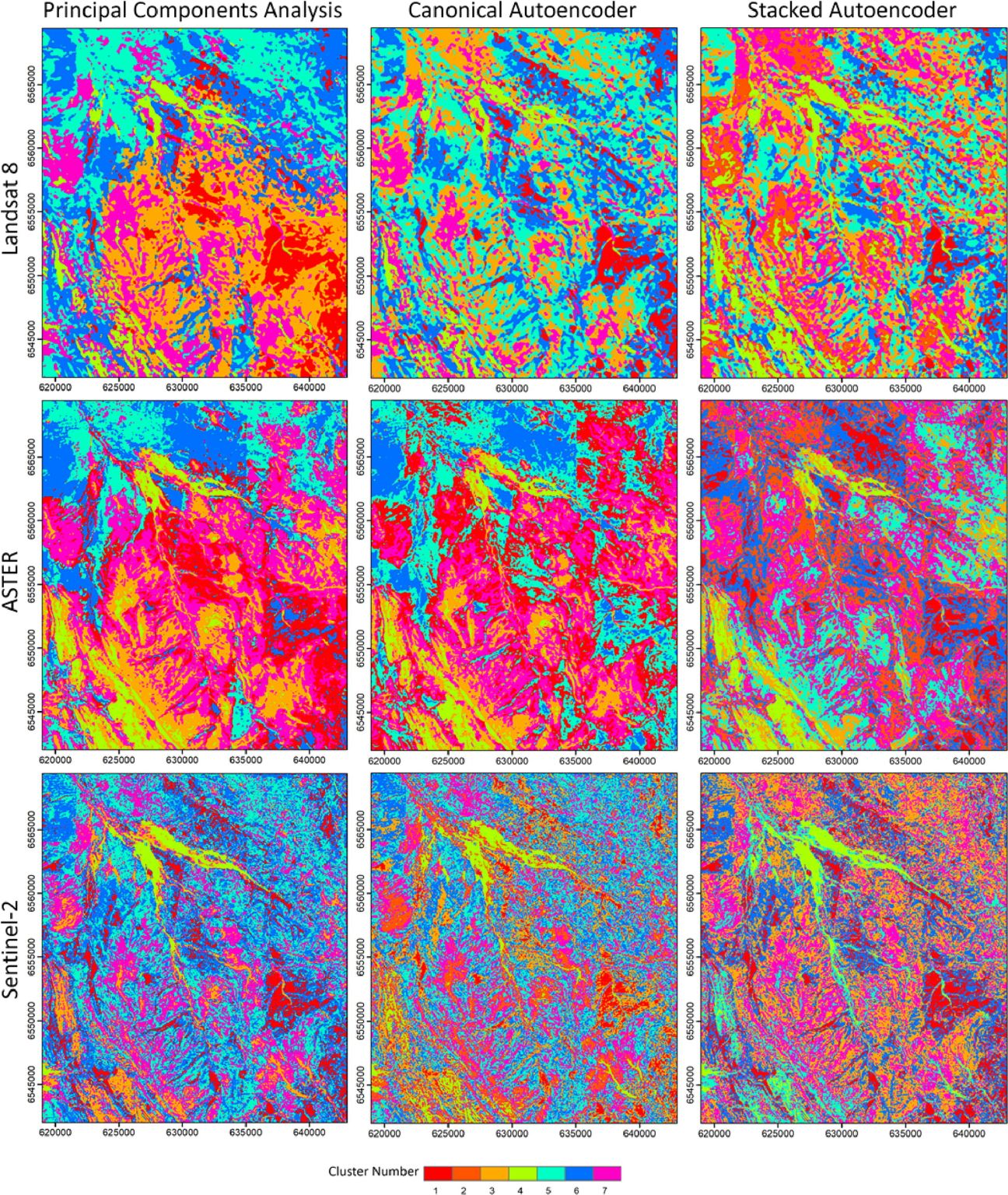
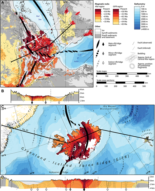
Subducting seafloor anomalies promote porphyry copper formation

Oceanic seafloor is scarred by age discontinuities, seamounts, and large igneous provinces (LIPs) over normal bathymetry. The recycling of these seafloor anomalies has been speculated to alter subduction regimes which may locally prime some regions for porphyry copper deposit formation. Using a tectonic plate reconstruction encompassing the last 100 Ma paired with a machine learning classifier … Read more…

A tectonically driven 60 million-year biogeochemical redox cycle paces marine biodiversity

The fossil record shows a prominent 60 million-year biodiversity cycle during the Phanerozoic Eon, the origin of which is still unknown. Here we use time-series analysis and correlation of empirical and model datasets of Earth’s interior and sur cial processes to demonstrate that this cycle is a pervasive feature in marine animal genus-level diversity data … Read more…

Convolutional Neural Networks for Mineral Prospecting Through Alteration Mapping with Remote Sensing Data

Traditional geological mapping methods, which rely on field observations and rock sample analysis, are inefficient for continuous spatial mapping of geological features such as alteration zones. Deep learning models such as convolutional neural networks (CNNs) have ushered in a transformative era in remote sensing data analysis. CNNs excel in automatically extracting features from image data … Read more…

Remote sensing framework for geological mapping via stacked autoencoders and clustering

Supervised machine learning methods for geological mapping via remote sensing face limitations due to the scarcity of accurately labelled training data that can be addressed by unsupervised learning, such as dimensionality reduction and clustering. Dimensionality reduction methods have the potential to play a crucial role in improving the accuracy of geological maps. Although conventional dimensionality … Read more…

Magnetization of Oceanic Lithosphere From Modeling of Satellite Observations

Magnetic observations from the oceans have made fundamental contributions to our knowledge of plate motions and the evolution of the geomagnetic field over the past ∼200 Myr. Here we construct updated models of magnetization for the oceanic lithosphere, taking advantage of the most recent models for Earth’s past plate motions. We then evaluate these models using … Read more…

Machine Learning and Big Data Mining Reveal Earth’s Deep Time Crustal Thickness and Tectonic Evolution: A New Chemical Mohometry Approach

Quantitative analysis of crustal thickness evolution across deep time poses critical insights into the planet’s geological history. It may help uncover new areas with potential critical mineral deposits and reveal the impacts of crustal thickness and elevation changes on the development of the atmosphere, hydrosphere, and biosphere. However, most existing estimation methods are restricted to … Read more…

Machine Learning-Based Spatio-Temporal Prospectivity Modeling of Porphyry Systems in the New Guinea and Solomon Islands Region

Abstract. The discovery of new economic copper deposits is critical for the development of renewable energy infrastructure and zero-emissions transport. The majority of existing copper mines are located within current or extinct continental arc systems, but our understanding of the tectonic and geodynamic conditions favoring the formation of porphyry systems is still incomplete. Traditionally, exploration … Read more…

Phanerozoic icehouse climates as the result of multiple solid-Earth cooling mechanisms

The Phanerozoic climate has been interrupted by two long “icehouse” intervals, including the current icehouse of the last ~34 million years. While these cool intervals correspond to lower atmospheric CO2, it is unclear why CO2 levels fell, with hypotheses suggesting changes in CO2 degassing rates or modification of silicate weathering through changing continental lithology or paleogeography. Here, … Read more…

Lamprophyres, gold and orogenies: a mineral systems perspective

The common spatial and temporal association of calk alkaline lamprophyres with orogenic gold deposits has been recognized for more than a century, although interpretations regarding the significance of this association have varied greatly. A persistent lack of consensus on Archean geodynamics and the deposits themselves presented a challenge to the use of a Mineral Systems … Read more…

pide: Petrophysical Interpretation tools for geoDynamic Exploration

pide is a Python library for calculating geophysical parameters (e.g., electrical conductivity, seismic velocity), employing the results from experimental petrology, mineral/rock physics, and thermomechanical modelling studies. pide can calculate the theoretical electrical conductivity of any Earth material that exists in the literature. pide can also calculate seismic velocity utilising the external ‘sister’ library SAnTex. Using … Read more…

Central Afar: An analogue for oceanic plateau development

The structure, composition, and evolution of oceanic plateaus are poorly understood and strongly debated. Here, we compared the magmatic history and crustal structure of Afar with the Greenland–Iceland–Faroe Ridge and other oceanic plateaus. Key similarities indicate that Central Afar represents the early stage of development of a specific type of oceanic plateau: a rifted oceanic … Read more…

Lithospheric Evolution and Uplift of the Tibetan Plateau During Continental Convergence: Evidence From Early Oligocene Pseudo leucite Phonolites from Southern Qian tang, Central Tibet

The Cenozoic collision of India and Eurasia clearly built the high-elevation Tibetan Plateau, but how this collision was accommodated, and the Tibetan Plateau uplifted, remains an area of study. The widespread occurrence of Cenozoic potassic–ultrapotassic lavas provides a valuable opportunity to constrain the relationship between surface deformation and underlying geodynamic processes. In this study, we … Read more…

Identifying Recycled Materials Using Mo Isotopes in Intraplate Alkali Basalts From the Southeastern Margin of Tibetan Plateau

Mantle heterogeneity in lithology and geochemistry is often attributed to recycled subducted materials. While distinct mantle end-members are identified by radiogenic isotopes, the specific recycled materials contributing to this heterogeneity remain debated. This study presents Mo-Sr-Nd-Pb isotopic data for OIB-like alkali basalts from the Maguan area in the southeastern Tibetan Plateau, focusing on slab inputs’ … Read more…

Lateritic Ni-Co prospectivity modelling in eastern Australia using an enhanced generative adversarial network and positive-unlabelled bagging

The surging demand for nickel (Ni) and cobalt (Co), driven by the acceleration of clean energy transitions, has sparked interest in the Lachlan Orogen of New South Wales for its potential lateritic Ni-Co resources. Despite recent discoveries, a substantial knowledge gap exists in understanding the full scope of these critical metals in this geological province. … Read more…

Solid Earth carbon degassing and sequestration since 1 billion years ago

Solid Earth CO2 outgassing, driven by plate tectonic processes, is a key driver of carbon cycle models. However, the magnitudes and variations in outgassing are poorly constrained in deep-time. We assess plate tectonic carbon emissions and sequestration by coupling a plate tectonic model with reconstructions of oceanic plate carbon reservoirs and with a thermodynamic model … Read more…

Leveraging Machine Learning and Geophysical Data for Automated Detection of Interior Structures of Cratons

The internal structures and discontinuities of cratons hold considerable economic value due to their tendency for reactivation and different horizontal stress, serving as conduits for fluid flow and mineral deposition over time. Detecting these structures at various depths is critical for accurately mapping prospective zones of metallic mineralisation. This study demonstrates the effectiveness of integrating … Read more…

Collaboration between artificial intelligence and Earth science communities for mutual benefit

A recent analysis concluded that Australia is at risk of losing its world-leading advantage in critical and rare minerals if it doesn’t sufficiently leverage artificial intelligence (AI). A large international coalition of Earth scientists and AI researchers is now advocating for stronger bidirectional development and impact between AI and Earth science in a new comment … Read more…

Spatio-temporal copper prospectivity in the American Cordillera predicted by positive-unlabeled machine learning

Porphyry copper deposits contain the majority of the world’s discovered mineable reserves of copper. While these deposits are known to form in magmatic arcs along subduction zones, the precise contributions of different factors in the subducting and overriding plates to this process are not well constrained, making predictive prospectivity mapping difficult. Empirical machine learning-based approaches … Read more…

Geoscience Frontiers: Earth’s tectonic and plate boundary evolution over 1.8 billion years

Understanding the intricate relationships between the solid Earth and its surface systems in deep time necessitates comprehensive full-plate tectonic reconstructions that include evolving plate boundaries and oceanic plates. In particular, a tectonic reconstruction that spans multiple supercontinent cycles is important to understand the long-term evolution of Earth’s interior, surface environments and mineral resources. Here, we present a new full-plate tectonic reconstruction from 1.8 Ga to present that combines and refines three published models: one full-plate tectonic model spanning 1 Ga to present and two continental-drift models focused on the late Paleoproterozoic to Mesoproterozoic eras. Our model is constrained by geological and geophysical data, and presented as a relative plate motion model in a paleomagnetic reference frame. The model encompasses three supercontinents, Nuna (Columbia), Rodinia, and Gondwana/Pangea, and more than two complete supercontinent cycles, covering ~40% of the Earth’s history. Our refinements to the base models are focused on times before 1.0 Ga, with minor changes for the Neoproterozoic. For times between 1.8 Ga and 1.0 Ga, the root mean square speeds for all plates generally range between 4 cm/yr and 7 cm/yr (despite short-term fast motion around 1.1 Ga), which are kinematically consistent with post-Pangean plate tectonic constraints. The time span of the existence of Nuna is updated to between 1.6 Ga (1.65 Ga in the base model) and 1.46 Ga based on geological and paleomagnetic data. We follow the base models to leave Amazonia/West Africa separate from Nuna (as well as Western Australia, which only collides with the remnants of Nuna after initial break-up), and South China/India separate from Rodinia. Contrary to the concept of a “boring billion”, our model reveals a dynamic geological history between 1.8 Ga and 0.8 Ga, characterized by supercontinent assembly and breakup, and continuous accretion events. The model is publicly accessible, providing a framework for future refinements and facilitating deep time studies of Earth’s system. We suggest that the model can serve as a valuable working hypothesis, laying the groundwork for future hypothesis testing.

Click on the image to watch the video on youtube

Cao, X., Collins, A.S., Pisarevsky, S., Flament, N., Li, S., Hasterok, D. and Müller, R.D., 2024. Earth’s tectonic and plate boundary evolution over 1.8 billion years. Geoscience Frontiers, p.101922.

Download the plate model from zenodoRead more…

Share

Applied Geochemistry: Multivariate statistical analysis and bespoke deviation network modeling for geochemical anomaly detection of rare earth elements

Rare earth elements (REEs), a significant subset of critical minerals, play an indispensable role in modern society and are regarded as “industrial vitamins,” making them crucial for global sustainability. Geochemical survey data proves highly effective in delineating metallic mineral prospects. Separating geochemical anomalies associated with specific types of mineralization from the background reflecting geological processes … Read more…

Geology: Submarine volcanism along shallow ridges did not drive Cryogenian cap carbonate formation – Reply

In their comment, Gernon et al. (2024) maintain that their “shallow ridge hypothesis” for cap carbonate formation (Gernon et al., 2016) is valid, disregarding abundant evidence to the contrary. Here we address four flaws in their argument. First, their hypothesis (Gernon et al., 2016) is based on a “proof by example” argument—a logical fallacy. Evidence … Read more…

Gondwana Research: Mapping paleoelevations along active continental margins with igneous geochemistry: A case study from South America

Mountains and mountain ranges, often situated at convergent plate margins, play a pivotal role in many fields of the Earth, climate, and biological sciences. Reconstructing past episodes of mountain building from the geological rock record is one of the main challenges for unravelling the ancient physical geography of Earth’s surface. Established methods for quantifying past … Read more…

Elements: Archean Geodynamics Underneath Weak, Flat, and Flooded Continents

Although a significant volume of crust was extracted from the mantle early in Earth’s history, the contribution of felsic rocks to the sedimentary record was minimal until ~3.0 Ga. On a hotter Earth, this conundrum dissipates if we consider that the felsic crust was buried under thick basaltic covers, continents were flooded by a near-global … Read more…

Nature Communications: Deep-sea hiatus record reveals orbital pacing by 2.4 Myr eccentricity grand cycles

Astronomical forcing of Earth’s climate is embedded in the rhythms of stratigraphic records, most famously as short-period (10^4–10^5 year) Milankovitch cycles. Astronomical grand cycles with periods of millions of years also modulate climate variability but have been detected in relatively few proxy records. Here, we apply spectral analysis to a dataset of Cenozoic deep-sea hiatuses … Read more…

New data set for refined boundaries between continental and ocean crust released

Earth’s topography and bathymetry with revised boundaries between continental and ocean crust overlain as thin red lines. We have released a refined data set of the boundaries between continental and ocean crust (COBs). The data can be downloaded from zenodo as GPlates-compatible gpmlz and as ESRI shapefile. The COBs are based on the data set … Read more…

Geology: Submarine volcanism along shallow ridges did not drive Cryogenian cap carbonate formation

The termination of Neoproterozoic “Snowball Earth” glaciations is marked globally by laterally extensive neritic cap carbonates directly overlying glacial diamictites. The formation of these unique deposits on deglaciation calls for anomalously high CaCO3 saturation. A popular mechanism to account for the source of requisite ocean alkalinity is the shallow-ridge hypothesis, in which initial spreading ridges … Read more…

Geology: Duration of Sturtian “Snowball Earth” glaciation linked to exceptionally low mid-ocean ridge outgassing

The Sturtian ‘Snowball Earth’ glaciation (~717–661 Ma) is regarded as the most extreme interval of icehouse climate in Earth’s history. The exact trigger and sustention mechanisms for this long-lived global glaciation remain obscure. The most widely debated causes are silicate weathering of the ~718 Ma Franklin LIP, and changes in the length and degassing of … Read more…

Tectonics: Differential Uplift Triggered Basin-And-Range System: Evidence From Low-Temperature Thermochronology in Eastern NE Asia

Since the Mesozoic, eastern NE Asia has experienced multiple tectonic events, resulting in a complex structure and forming one of the world’s largest Meso-Cenozoic lacustrine basin systems. Presently, basin evolution models require further elucidation regarding the simultaneous generation of diverse rift basins and the potential impact stemming from the closure of the Mudanjiang Ocean, whose … Read more…

Nature: Landscape dynamics and the Phanerozoic diversification of the biosphere

The long-term diversification of the biosphere responds to changes in the physical environment. Yet, over the continents, the nearly monotonic expansion of life started later in the early part of the Phanerozoic eon1 than the expansion in the marine realm, where instead the number of genera waxed and waned over time2. A comprehensive evaluation of … Read more…

Environmental controls on the resilience of Scott Reefs since the Miocene (North West Shelf, Australia): Insights from 3D seismic data

North and South Scott Reefs are isolated carbonate platforms separated by an inter-reef channel on the NWS, Australia. They evolved from a barrier reef in the Miocene, and into isolated carbonate build-ups (ICB’s) during the Pliocene, and finally to the isolated carbonate platforms that continued to present day. However, the timings of coral reef turn … Read more…